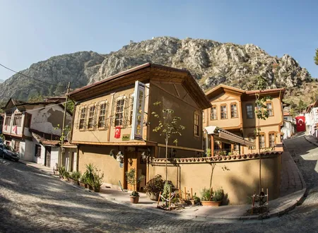
The age of some neighborhoods cannot be calculated from a population register; it shows in the name of a gate, in how many times a bridge was beaten by the river, or in the death of the last old man who still remembered a street's former name. Nergis Mahallesi in Amasya is such a place. Written Nergiz Mahallesi in some official records and often given as "Nergis (Helkıs)" or "Nergiz (Helkis)" in academic studies, it is not one of the city's large neighborhoods, and its population has been shrinking for years. Still, measuring the importance of a city by its population alone is like weighing an old book to judge its worth by the gram. Nergis draws its weight from its position: it lies at the foot of Harşena, on the bank of the Yeşilırmak, in the shadow of the old palace, its name was once given to a castle gate, and it carries the traces of periods written one over another across centuries in the same narrow geography.
Origin of the Names Nergis and Helkis
The surest way into the neighborhood's history is to begin with Helkis, the name used before today's "Nergis." In Amasya Tarihi (History of Amasya) by Hüseyin Hüsameddin Yasar, one of the principal local sources on Amasya's past, the neighborhood is described in detail under the name Helkis. According to Yasar, the old Helkis quarter began north of Alçak Köprü (the Low Bridge) and reached Leğenkaya near Kuş Köprü; the Yeşilırmak lay on its east and south, Saray Mahallesi on its west and Mount Harşena on its north. Historically the quarter was referred to in two parts, Sade Helkis and Bağ-ı Helkis. Recent academic studies show that this description largely matches the city's topography.
Yasar links the name Helkis to a person called "Halkis," one of the Greek notables he says lived in the region before the conquest. By his account, the land between this man's garden in the east and his house in the west came in time to be called by his name, and the name later turned into "Helkis." The explanation matters for local historiography, but it cannot be counted as an etymology verified by linguistic methods; it should be read as an account handed down by the local historical tradition.
The history of the name Helkis is not confined to the Ottoman period either. Listing the quarter names in use in Byzantine Amasya, Yasar mentions Atakyus, Fokas, Kirağus, Eleksiyus, Komnus, Yanus, Tekfur and Helkis; this record shows that the name was at least associated with Amasya's Byzantine memory. One of the old gates of the castle is also known as the Helkis Gate. The Ministry of Culture and Tourism's presentation of Amasya Castle states that a "Nerkis Mahallesi" lies east of the Inner Castle and that, of the castle's four gates, the one facing Nerkis is called the Helkis Gate. The name of the quarter thus ceases to be merely an everyday place name and enters the city's defensive topography as well.
Open-access sources do not provide a definite document for when and by what administrative act "Nergis" replaced Helkis, so it would be wrong to give a particular date for the change. In present-day publications Nergis, Nergiz and, in parentheses, the old name Helkis or Helkıs are used side by side. A 2021 academic study defines the area as "Nergis (Helkıs) Mahallesi," while the map title in another study from 2024 reads "Amasya Central District Nergiz (Helkis) Mahallesi." The old name has therefore not been entirely forgotten.
The Site of Nergis in Ancient Amaseia
It is not possible to describe today's Nergis Mahallesi as a neighborhood within its present administrative boundaries in antiquity; carrying municipal neighborhoods back into the past unchanged would be an anachronism. It is certain, however, that the geographical area on which the neighborhood stands adjoined the ancient core of Amaseia. The Nergis/Helkis area forms part of the narrow corridor between the Harşena cliffs in the north and the Yeşilırmak in the south. While the ancient acropolis with the rock tombs of the Pontic kings rises above Harşena, the valley floor below carried the city's riverside settlement. Amasya was an important center in the Hellenistic Kingdom of Pontus and for a time its capital; the geographer Strabo was also born in Amaseia.
The Amaseia described by Strabo is a city ringed by high cliffs, cut in two by the river and easy to defend. Looking at the Nergis area today, it is still clear why it was described so: the mountain stands on one side, the water on the other, and between them there is room for little more than a city. In the Roman period Amasya was an important center within Galatia and later administrative arrangements and held a central role in the regional road system; coins are known to have been minted in the city from the time of Domitian to the reign of Severus Alexander.
It is geographically a very strong possibility that the northern bank strip where Nergis lies was one of the transition areas between city and castle in antiquity. But to say that a particular Roman building stood within today's Nergis Mahallesi, an archaeological excavation or a clear epigraphic document would be needed. What is known is that the neighborhood's topography neighbored the central defensive and transport zone of the ancient city; there is no documentation on the layout of individual streets and houses in this area.
The Geography of Helkis in the Roman and Byzantine Periods
Under Roman rule Amaseia was not only a military city; it was a regional center with administrative, economic and religious functions. After Diocletian's reorganization the city became one of the important administrative and religious centers of Diospontus, and in the Byzantine period it kept its strategic importance within the Armeniakon theme system. What makes the Nergis/Helkis area significant for this period is the relation between castle and river.
The extension of the lower sections of Amasya Castle and of the palace areas toward the Yeşilırmak, together with the Kızlar Sarayı (Maidens' Palace) and the inner-castle surroundings mentioned in later sources, suggests that this was not only a defensive zone. The Ministry of Culture and Tourism records mention the ruins of the Kızlar Sarayı south of the Inner Castle, said to be of Hellenistic origin and reported to have been in use until the Ottoman period; according to the same records Nerkis lies east of the Inner Castle. Yasar, for his part, records that in some old sharia documents the area around the palace is called "Foka," and that various quarter names, Helkis among them, were in use in Amasya in the Byzantine age. It is therefore possible to trace Helkis in Byzantine Amasya at least as a naming tradition.
The Danishmendid Period
Amasya's passage under Turkish rule took place in the last quarter of the 11th century with the Danishmendids. With Danishmend Ahmed Gazi's capture of Amasya and its surroundings, a new political and cultural period began in the city. Danishmendid rule lasted about a century; in 1175 Amasya was joined to the lands of the Anatolian Seljuks by Kılıç Arslan II. Information documenting the detailed street fabric of the Helkis area in this period is limited. Even so, as Amasya turned into a Turkish-Islamic urban fabric, it is clear that the castle slopes, the bridgeheads and the routes leading to the river kept their importance. When a city is conquered, everything does not change overnight; language and signs change first, while place names often live on for centuries. That the name Helkis was carried into later ages is remarkable in this respect.
The Seljuk Period
The Seljuk-period record concerning Helkis is of interest. According to Yasar, around the year 690 of the Hijra, that is about 1291 CE, Hâce Muhibüddin Mevdûd Ziyârî had a mosque built in the Helkis quarter and beside it a dârü'l-ilm (house of learning), an educational building. The exact location of the buildings is not known today. This record suggests that Helkis was not made up of dwellings alone and that it had, at an early date, a neighborhood fabric with religious and educational functions. Of a school founded in a neighborhood eight hundred years ago, only this record remains today.
Seljuk Amasya was an important cultural center in the 13th century. The construction of large buildings such as the Gök Medrese shows the city's scholarly and architectural capacity; the Gök Medrese is known to have been built in 1267 by Seyfeddin Torumtay. The mosque and dârü'l-ilm recorded in Helkis must be a more modest, neighborhood-scale part of this larger urban culture.
Helkis in the Ilkhanid Period
After the Battle of Köse Dağ in 1243 the Anatolian Seljuk political structure came under Mongol pressure; from the second half of the 13th century the Ilkhanids established direct control over Anatolia, and Amasya was part of this transformation. One of the notable features of this period for Helkis is that the neighborhood becomes visible in documents through its gardens and endowed properties. In another record of Yasar's, it is stated that in 802 AH, that is about 1399-1400, a person endowed the Helkis Garden, together with all its appurtenances, to the mosque of Gümüşlüzâde Tâceddîn Mahmûd Çelebi.
This record shows that Helkis was not a crowded riverside quarter made up of houses alone; the fact that part of its name was Bağ-ı Helkis (Vineyard of Helkis) is consistent with this. Behind the houses there were gardens, vineyards, fruit trees and water. Through the endowment system the income of a garden could be channeled to another building's lamp oil, imam, upkeep or other needs. In this respect the old city was a network of buildings indebted to one another: the fruit of one tree could light the lamp of a mosque in another street.
Helkis in the Ottoman Period
Amasya passed under Ottoman rule in the late 14th century. In the early Ottoman period in particular the city gained extraordinary importance for the dynasty; during the Interregnum it was one of the centers of Çelebi Mehmed's struggle, and in the following century it became one of the most important sanjaks where Ottoman princes served. Helkis is a more visible neighborhood in the documents of this period. The mention in Yasar's biographical records of various people living in Helkis allows a partial view of the neighborhood's social fabric. For example, the family of Çolak Hüseyin Pasha is recorded as belonging to the notables of the Helkis quarter; other records show people who died in Helkis or lived in the Helkis Garden. The neighborhood thus ceases to be merely a geographical name and becomes an identity indicating social belonging; to say "of Helkis" could, at that time, amount to giving an address.
Helkis in the Sharia Court Registers
The most important group of sources for researching Amasya's history at neighborhood scale is the sharia court registers (şer'iyye sicilleri). Academic research on the first 22 volumes, from the 17th century, has shown that there are about a hundred registers belonging to Amasya. These volumes can contain, besides lawsuits, sales, inheritances, estate inventories, endowments, marriages, divorces, debts, guardianship transactions, prices and neighborhood names. Register no. 7 of the Amasya Sharia Court, covering the years 1648-1649, is among the sources that give information on the period's neighborhoods, villages and administrative structure.
A methodological distinction is needed here. It is known that Helkis appears in the sharia registers, and Yasar too relies in his work on numerous sharia documents and endowment records. But without transcribing each register one by one, details such as the price at which a particular resident of Helkis sold a particular house in a particular year cannot be asserted. The way to reconstruct a neighborhood from documents often runs through estate inventories: how many copper bowls and quilts were left behind when someone died, how many rooms a house had, how many vineyard shares were in a woman's inheritance, who became guardian of a minor child are all written in these records.
The Endowments of Helkis
Endowments hold an important place in the historical structure of Helkis. One of the earliest records is that of the mosque and dârü'l-ilm belonging to Hâce Muhibüddin Mevdûd Ziyârî, dated to about the late 13th century; in another, the Helkis Garden is seen endowed to a mosque. These examples show that the neighborhood took part in the city economy through the endowment network. In Ottoman and Seljuk cities an endowment was not merely a charitable act; it was one of the means of financing what we would now call municipal services, social aid, education, religious services and, at times, infrastructure. A shop, a vineyard, a garden or a mill would be endowed, and its income kept another building alive. For this reason it is incomplete to see the old vineyards of Helkis only as agricultural landscape; part of them belonged to an economic system.
Mosques, Masjids, Bridges and Historic Buildings
One of the oldest known places of worship in Helkis is the Muhibüddin Mevdûd Ziyârî mosque mentioned above; it is no longer standing, or its exact location could not be determined. Not all the structures that made the neighborhood important through history were religious either. One of the most notable is the Helkis Bridge. Yasar names the old crossing near the Hükümet Köprüsü (Government Bridge) the Helkis Bridge and records that the name was given because the residents of Helkis used this bridge; information is also given on repairs to the bridge in different periods. The name Helkis thus passes from the neighborhood to the bridge, and from there to the Helkis Gate opening onto the Nergis side of the castle. From a neighborhood whose name lives on in both a gate and a bridge, it can be understood that the city really did pass through it.
In the late Ottoman period the Helkis area became one of the important fields of Amasya's modernization activity. A recent study examines in particular the building and planning works in Helkis during Ziya Pasha's term as governor of Amasya. The turn of public buildings and of the transport order toward this district in the 19th century added an administrative layer to the neighborhood's old residential fabric. The old municipality building in the neighborhood today is one of the witnesses of this transformation. According to cultural inventory records the building dates to the early 20th century and is recorded as one of the first buildings where Mustafa Kemal Pasha was received on his arrival in Amasya on 12 June 1919.
Traditional Amasya Houses and Nergis
One of Nergis's most important cultural assets, even today, is its traditional residential fabric. Amasya's traditional houses largely represent 19th-century Ottoman domestic architecture. The hımış technique, with mudbrick infill between a timber frame, together with plastered lath work, projecting upper floors, bay windows, courtyards and hipped or gabled roofs, are the basic features of these houses; many buildings were registered under a protection decision of 1992. There are also examples of traditional dwellings in Helkis/Nergis that have been taken into the cultural inventory. A building recorded near Hatun Sokak is two storeys with a garden, built in the hımış system with mudbrick infill between a timber frame; its upper floor has a projection, and it uses guillotine-type windows and a roof of traditional curved tiles. Listed as Ottoman in cultural period, this building is one of the concrete examples of traditional architecture in the Helkıs neighborhood.
The charm of these houses comes from their imperfection. A wall leans a little, the timber has darkened, a window presses too close to the street; the stone of the ground floor survives from one century, the planks of the upper floor from another repair. The architect and the builder of some of the structures are unknown, but the house stands in its place.
Neighborhood Life
Ethnographic sources that directly describe the neighborhood life of Helkis are limited. On the other hand, the geographical and architectural structure gives clues about the character of neighborhood life. A narrow valley, limited space between mountain and river, adjoining or nearby houses, small streets, gardens, and a daily life tied by bridges to the opposite bank must have supported the strong neighborliness seen in traditional neighborhoods. In such a neighborhood a neighbor is within calling distance of a window, children grow up in the street and everyone knows whose child is whose. Given the rapidly shrinking population of today's Nergis, it is hard for this social structure to keep its former intensity, but the street fabric still carries the measure of the old life.
Demographic Change
The most striking aspect of Nergis's recent story is the long-term decline of its population. According to the population series compiled from TÜİK ADNKS data, the population of Nergiz Mahallesi, 264 people in 2007, rose to 292 in 2010 and then entered a general downward trend. It stood at 231 in 2015, 201 in 2018, 160 in 2020, 148 in 2023 and 139 in 2024, and was recorded as 145 people in 2025; of the 2025 population, 73 are men and 72 are women. According to these figures the neighborhood's population fell by about 45 percent between 2007 and 2025.
A recent tourism and conservation study also states that the neighborhood has generally lost population continuously since 2007. According to an interview with the muhtar in the same study, the neighborhood has about 55 households, some of the old and elderly residents have left and some tenants have taken their place. The research also draws attention to areas evacuated because of disaster risk. The question in Nergis is therefore the protection of the living neighborhood together with its historic buildings.
Nergis in the Republican Period
The early years of the Republic changed the position of Nergis/Helkis within the city seriously, and one of the clearest elements of this is the railway. According to academic research, the opening of the Amasya railway line in 1927 became an important urban element that physically divided the Helkis neighborhood into two parts. Today the section between the Hükümet Köprüsü and the Künç Köprü holds the Governorate, public buildings, and military and tourist structures, while in other parts the historic residential fabric keeps its weight. This change is like a small summary of Turkey's 20th-century urbanization story: the horse carriage passing in the street was replaced by the train, public buildings were built next to the old vineyards, gardens shrank and roads widened. Although the neighborhood continued to bear the same name, its physical and social structure changed profoundly in the process.
1919 and the Memory of the National Struggle
One of the special points of Nergis/Helkis in Republican history is Mustafa Kemal Pasha's arrival in Amasya. According to cultural inventory records, the old municipality building in the Helkis neighborhood is recorded as one of the first buildings where Mustafa Kemal was received when he came to Amasya on 12 June 1919. When Amasya is mentioned, the Amasya Circular comes to mind first; but great events also have a small geography: the place where one steps down from the carriage, the first building entered, the room where one waits. These details, which take up a sentence or two in history books, are for the neighborhood the concrete anchor of that day's memory.
Nergis Today
Today's Nergis/Helkis is one of Amasya's important history and tourism corridors. Together with Hatuniye it lies in the historic band between the Yeşilırmak and Harşena; academic landscape studies treat these two neighborhoods as a tourism axis about two kilometers long. The district is connected to other parts of the city by crossings such as the İstasyon Köprüsü, the Mağdenüs Köprüsü, the Alçak Köprü and the Hükümet Köprüsü. The function also varies across different parts of the neighborhood: the section between the Hükümet Köprüsü and the Künç Köprü stands out for public uses, while in other parts the residential character is pronounced. The neighborhood also forms one of the important parts of the urban conservation area; in conservation studies the whole of Helkis Mahallesi has been treated as a separate conservation sub-zone, with particular attention to the traditional Amasya residential fabric.
Today's central question is what the neighborhood will be preserved as. Preserving it as scenery, as a hotel district, as an open-air museum or as a real neighborhood where people continue to live leads to different outcomes. Tourism can save a neighborhood, and it can also empty it; not every restored house means that culture has been preserved, and sometimes only the building survives.
From Bağ-ı Helkis to Nergis
The use of the name "Bağ-ı Helkis" in old sources is important for understanding today's neighborhood. For a visitor looking at today's dense urban fabric it is not easy to imagine that there was once a vineyard and garden fabric here; yet the old city was greener than this. Neighborhoods were not made up of building plots alone; beside the houses there were gardens, vineyards, walls, fruit trees and water. The appearance of the Helkis Garden in endowment records shows that this landscape carried an economic value beyond the aesthetic. Today the name "Nergis" inevitably brings the flower (narcissus) to mind; but there is no document showing that the name derives from the lost gardens of Bağ-ı Helkis, and the reason for the change of name is not known.
The Place of Old Helkis in the City
According to the historical descriptions, Helkis is an important northern bank settlement stretching along the foot of Harşena; the Yeşilırmak lies on its east and south, the mountain on its north and the historic Saray area on its west. The distinction between Sade Helkis and Bağ-ı Helkis suggests topographical and functional differences within the neighborhood itself. This position made the neighborhood both sheltered and fragile. Its place at the foot of the mountain protects it, but the same mountain can drop rock; the river gives life, but the same river can flood. Like many neighborhoods of Amasya, Helkis has continued to exist under the threat of the very geography that sustains it.
Chronology of Nergis Mahallesi
Antiquity: The present Nergis area lies in the close surroundings of the settlement area of ancient Amaseia below the acropolis on Harşena and the Pontic royal tombs. Amasya is an important center under Pontus and then under Roman rule.
Roman-Byzantine period: Amasya keeps its character as an administrative and religious center. Local historical sources report that a neighborhood name "Helkis" existed in the Byzantine age.
Late 11th century: Amasya comes under Danishmendid rule.
1175: Kılıç Arslan II takes Amasya under Seljuk rule.
About 1291 / 690 AH: Hâce Muhibüddin Mevdûd Ziyârî is recorded as having had a mosque and dârü'l-ilm built in Helkis.
13th-14th centuries: Amasya is within post-Seljuk Ilkhanid influence and local political arrangements.
802 AH / about 1399-1400: There is a record of the Helkis Garden being endowed together with its appurtenances.
Early Ottoman period: Amasya becomes a princely sanjak and an important administrative center. Helkis keeps its place in the urban fabric.
17th century: Amasya's sharia court registers record the social and economic life of neighborhoods in detail; the name Helkis continues to live in local historical sources as an Ottoman neighborhood.
19th century: Helkis becomes one of the important areas affected by the city's building and planning works in Ziya Pasha's time.
Early 20th century: Public buildings such as the old municipality building join the neighborhood fabric.
12 June 1919: Mustafa Kemal Pasha is recorded as having been received in the old municipality building on his arrival in Amasya.
1927: The opening of the railway line changes the neighborhood's spatial structure considerably.
1992: Amasya's many historic houses are brought under protection decisions; the traditional residential fabric of Helkis/Nergis is protected within the urban conservation area system.
2007: In the ADNKS series the population of Nergiz is 264.
2020: The population falls to 160.
2025: The population is 145.
Conservation and the Future
To describe Nergis as a charming Amasya neighborhood with historic houses falls short, because several distinct periods lie here one upon another: ancient Amaseia, Byzantine Helkis, the Seljuk neighborhood, the Ottoman Sade Helkis and Bağ-ı Helkis, and the Republic's Nergis. None of them has vanished entirely; one lives on in its gate, one in the garden in an endowment document, one in a mosque that survives only in books, one in the houses of the street, one in the name on the sign.
For this reason the conservation of the neighborhood is not a matter limited to architectural restoration. Keeping the name Helkis from being lost is a matter of name memory. The fall of the population by nearly half between 2007 and 2025 shows that the living fabric, as well as the historic fabric, is at risk. The railway, public buildings, tourism facilities, areas at disaster risk and historic houses touch one another in the same small geography, and this is a condition that shapes urban planning. Tourism, too, cannot be reduced to bed capacity: a historic house with washing hung at its window and people still living in it may offer a more real experience than a building turned wholly into stage decor in which nobody lives.
The steps proposed for the neighborhood can be listed as follows: keeping the old names alive on street signs, explaining the boundaries of Sade Helkis and Bağ-ı Helkis within the city, marking the axis where the Helkis Gate stands, researching the approximate location of the lost mosque and dârü'l-ilm, systematically surveying the sharia court registers, and including the old families in an oral history project. It may also be considered to use emptied traditional houses not only as lodging facilities but also as artists' residences, research houses, urban archives and small cultural venues.
Sources
Primary sources
- Hüseyin Hüsameddin Yasar, Amasya Tarihi, digital edition of Amasya Municipality. Yasar's work is one of the basic local sources for the boundaries of Helkis, the Sade Helkis–Bağ-ı Helkis distinction, endowments, persons, the bridge and neighborhood history.
- Fatma Gül Töremiş, "7 Numaralı Amasya Şer'iyye Sicilinin Tanıtımı", Akademik MATBUAT, 2019. amasya.bel.tr
- Hacer Bahadır – Yılmaz Karadeniz, "5 Numaralı Amasya Şer'iyye Sicilindeki Mülk Satışlarına Dair Değerlendirme (1643-1645)", Akademik MATBUAT, 2019.
Academic studies
- Neşe İnak, "Amasya Tarihinin Kaynaklarından Şeriye Sicilleri (17. Yüzyıl)", Ondokuz Mayıs Üniversitesi İnsan Bilimleri Dergisi, 2023.
- Academic studies on the protection of Amasya's historic urban area and research on sustainable tourism/conservation in Nergiz Mahallesi.
Official sources
- Republic of Türkiye Ministry of Culture and Tourism, Amasya Kalesi; the relation of the Inner Castle, the Helkis Gate and Nerkis Mahallesi.
- Türkiye Kültür Portalı, Helkıs Mahallesi Geleneksel Konut Envanteri and Belediye Eski Binası records.
Other sources
- Sultan Sevinç Kurt Konakoğlu – Gizem Büyükgüner, "Amasya Kenti Hatuniye Mahallesi ve Nergis (Helkıs) Mahallesi Örneğinde Kentsel Donatı Tasarımı Süreci", Humanities Sciences, 2021.
- "Helkis Mahallesi ve Ziya Paşa'nın İmar Faaliyetleri", publication of Amasya University Social Sciences Research.
- Amasya Governorate, Amasya Adının Kökeni, Amasya Evleri, Selçuklu Dönemi.
- The Nergiz Mahallesi 2007–2025 population series compiled from TÜİK ADNKS data.
Online sources


