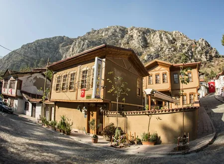
Boğazköy Mahallesi, a neighbourhood of Amasya's central district, does not appear in the familiar picture of the city with its citadel, its riverside mansions and its rock-cut tombs. It is a small settlement of a few hundred people, met with on the way out of the city towards Samsun, in the narrow valley through which the Tersakan stream comes down from Suluova to Amasya. The city's narrow-valley look, pressed against stone and slope, gives way here to more open ground stretching along both banks of the stream. This part, absent from the postcards of Amasya, stands on the road and the railway that link the city to the Black Sea, and its best-documented feature is its station on the Samsun-Kalın line. Few written records concern the neighbourhood's own past; the valley in which it lies, by contrast, was well known to Amasya's older historians and was regarded as the northern gate of the city. Accounts of the valley should not be confused with documents about the neighbourhood itself, and throughout what follows it is stated which information belongs only to the valley and which bears directly on Boğazköy.
Distinguishing It from Its Namesake
In Turkey, the name "Boğazköy" brings to most readers' minds Hattusa in Çorum. That settlement, the Hittite capital and a UNESCO World Heritage Site, was formerly known as Boğazköy and has no administrative connection with Amasya. Because several other villages and neighbourhoods in Turkey share the name, information about different places is often confused in search results.
The confusion also shows up in the archaeological literature. In a surface-survey article on the Iron Age settlements around Amasya, Merzifon and Suluova, Boğazköy/Büyükkale and Boğazköy/Büyükkaya appear only as excavation sites in Çorum, cited for ceramic comparison. The mounds of the region, such as Oluz Höyük, Doğantepe and Gediksaray Höyüğü, are discussed separately in the same study; the Boğazköy neighbourhood of Amasya does not appear in this inventory as a settlement. In Hüseyin Hüsâmeddîn Yasar's Amasya Tarihi (History of Amasya), a sentence quoted from a French academician lists the remains of a pre-Pontic state as found in "Amasya, Öyük, Boğazköy and their surroundings"; judging from the attribution of these remains to the Hittites and from the mention of Boğazköy alongside Öyük, this Boğazköy too is most probably the archaeological site in Çorum. No information about the Hittite capital or about Iron Age finds can therefore be attributed to this neighbourhood.
A similar closeness exists within Amasya itself. A place-name study based on Ministry of the Interior data lists among the villages of Merkez a Boğaköy, spelled with a single z, and reports that its former name was Kaşka. The same study mentions Boğazköy separately among the villages later converted into neighbourhoods, so the two names point to two different settlements. Boğazköy does not appear in the table of changed place names, and no record of a renaming that produced the neighbourhood's name is therefore visible.
Amasya's Northern Gorge and the Origin of the Name
No definite document on when or why the neighbourhood received its name has been found in openly accessible sources. The word "boğaz" means a narrow pass, or the gap between two heights, in Turkish, and it is the first element of many place names across Anatolia. In Amasya's case the word also has a local meaning. Hüsameddin describes the city as a place enclosed by mountains on every side and writes that the points where these mountains open are known collectively as the "Amasya Boğazı", the Amasya gorge. In his account three gorges open onto the city like three gates: the Sonusa-Taşova gorge to the north-east, the Derbend-Çalan gorge to the south-west, and the gorge to the north facing Arguma and Suluova. The southern and northern gorges are narrow, while the north-eastern one is fairly wide. The northern gorge is about ten kilometres long, the southern one about four. Hüsameddin adds that a river flows through each of the three, that the vineyards and gardens on both banks of these rivers are highly prized, and he likens the city with its three gates to a great pavilion or a well-fortified palace.
Boğazköy lies within the one of these three passes that opens towards Suluova, that is, within the northern gorge through which the Tersakan flows. Local press reports state plainly that the stream passes through Boğazköy, and Hüsameddin says that after crossing the middle of Suluova the Tersakan enters "the northern gorge of Amasya". The position of Boğazköy station on the railway, between Amasya Station and Saluca to the north, likewise shows that the settlement lies on the route running along this valley. It is therefore reasonable to think that the "boğaz" in the neighbourhood's name refers to this pass, regarded as the city's northern gate. This, however, is only an inference from geography; no local tradition or written record describing how the name was given has been found.
Location and Area
The neighbourhood lies within the administrative limits of Amasya's city centre. It lies north of Hızırpaşa Mahallesi, where Amasya Station stands; a traveller heading from the city towards Samsun reaches the surroundings of this settlement after leaving behind the old core in the shadow of the Harşena and Ferhat mountains and entering the Tersakan valley. The railway line is the most visible element linking it to the city centre, and today it largely defines the settlement's relation to the city. When the headman of Göllü Bağları Mahallesi, on the banks of the same stream, called in 2022 for a treatment plant, speaking of "our Boğazköy area" amid complaints about pollution, he showed that the two settlements share the same watercourse.
Compilations based on TÜİK data give the neighbourhood's area as 4.715 square kilometres. In the same table some of Amasya Merkez's neighbourhoods cover less than one square kilometre, so Boğazköy's spread over so large an area with a population of only a few hundred suggests an open, semi-rural character rather than a dense urban fabric. This last assessment is not stated in the sources; it is an interpretation drawn from the figures.
The Tersakan Stream
The stream that runs through Boğazköy is introduced separately in the older sources as one of Amasya's three rivers. According to Hüsameddin it was called Tersakan, "the one that flows the wrong way", because it runs from north to south. The author infers from its record in the work Ahbâru'l-İbâd under the Arabic name "En-Nehrü'l-Maklûb", "the inverted river", that the name had been current among the Turks since the conquest. Hüsameddin writes that in older documents the river appears under the names "Astifonos" and "İstiyotos", and suggests that the second may be a corrupted form of the Turkish word "Setit"; this last interpretation is the author's own and is not supported by any other source.
As Hüsameddin describes it, the stream rises north of the district of Lâdik, passes east of Havza and through the middle of Suluova, enters the northern gorge, and joins the Yeşilırmak above the place called Bahçeler İçi. Its flow is constant: it falls in summer and rises in spring. Because it overflows and damages its surroundings when in spate, people also call it "Deliçay", the mad stream. The author records that many factories, mills, vineyards and gardens on its two banks drew on its water. In his account the vineyards along the banks of the three rivers are named together with Amasya's abundance of fruit.
Two bridges stand over the stream which Hüsameddin calls "famous and ancient". The Ziyare Bridge lies near the point where the stream joins the Yeşilırmak, on the Ziyare road; the author infers that it was built by the Seljuk sultan Mesud from its old name, "Mesud Bridge", and from its architectural style. The other is the single-arched Çeltek Bridge at the end of Suluova, where the Amasya road and the Merzifon road part. He writes that its arch was narrow and high and its deck steep, and that since the hijri year 1300 (1882-1883) the repeatedly repaired highway had filled in both sides, so that the arch now sat low and the top had become level. One of the bridges stands where the stream reaches the city, the other where it leaves Suluova; Boğazköy lies in the valley between these two points. No record has been seen of a historic bridge within the neighbourhood's own limits.
According to present-day records the Tersakan rises in Lake Ladik, is 91.4 kilometres long and is one of the left-bank tributaries of the Yeşilırmak. Its catchment covers 2,684 square kilometres. After leaving the lake it flows first west, then south, then east, and joins the Yeşilırmak. This agrees with Hüsameddin's description; the two accounts, both placing the stream's source at Lâdik and its mouth in the city of Amasya, are about a century apart.
The History of the Northern Gorge
The history of Amasya reaches back to the Neolithic and Chalcolithic periods through potsherds and architectural traces found in its mounds. The city was incorporated into Ottoman territory in 1393 and, from the first half of the fifteenth century, became a sanjak where princes served and the centre of the Eyalet of Rum. In this long history the name of Boğazköy, apart from the station, does not appear separately in any document. The northern gorge in which the neighbourhood lies, on the other hand, is mentioned again and again in Hüsameddin's narrative, since every army and traveller coming to the city from the Black Sea had to pass through it. The events below concern the gorge as a whole, and none of them is documented as having taken place within the present limits of Boğazköy.
According to Hüsameddin, near the end of the gorge that opens towards Suluova there stood a castle built in two parts facing each other on either side of the pass. This structure, whose remains could be made out in his time only as faint traces, is Arguma Castle. The author notes that the gorge, the castle and the broad plain in front of it always appear under the name "Arguma" in old records, and that the name was written in various forms such as "Arguma, Argumas, Argunama, Argunamas". From these forms he argues that the name is a shortening of "Argun Amas" and that the castle was built by a ruler named Argun Han. This etymology and the royal lineage he offers in its support are the author's own interpretation and are not supported by any other source. As another castle overlooking the gorge from within the city he names Bâlus Castle, south-east of the Beyler Sarayı; he writes that this small castle on high ground was regarded as the guardian of the gorge because it faced the northern pass.
The episode that best shows the gorge's military importance is Hüsameddin's account of the Roman commander Lucullus's entry into Amasya. In his telling, when Lucullus, fighting the Pontic king whom Hüsameddin calls "the Seventh Mihridâd" and who is today generally known as Mithridates VI, marched on the city at a date the author gives as "693 years before the hijra", Argun Castle in front of the northern gorge could not withstand the assault and was forced to guide his army. Ilis, the guardian of Amasya, realising that he could not resist a large army, surrendered Harşena Castle peacefully to save the city from destruction. Lucullus entered the city through the northern gorge in a magnificent procession and encamped on the meadow north of Bahçeler İçi that was known in the author's time as "Gülüs". Hüsameddin adds that the city escaped destruction but suffered heavy plundering. Some of the personal and place names in the narrative are the author's own readings, and no other source has been found that confirms all of these details.
In the Middle Ages, too, the gorge acts as a kind of boundary between whoever held the city and whoever dominated its surroundings. Hüsameddin writes that Abadoğlu Mübarizeddin Sevündük Bey lived in the village of Hakala, "in front of the northern gorge of Amasya, facing Suluova", and that through his efforts Hakala became a pleasant small town. At another time Kara Devletşah came with some twelve thousand horsemen, pressed up to the northern gorge, descended on Hakala, took Suluova and governed the surroundings of Amasya from there. At that point the city had two governors: Yakut Paşa held the city and the citadel, Kara Devletşah the country outside. Hüsameddin adds that the people of Amasya seized the gorges and closed them. These accounts show that the pass in which Boğazköy lies was for centuries the line along which the city was defended, or besieged, from the north.
The gorge also has its place in Amasya's tradition of holy men. Saying that every side of the city has the station of a meczup, an ecstatic holy man, Hüsameddin names Tekirdağlı Baba in the northern gorge, Has Baba in the southern gorge, Abdurrahman Baba to the east and Memi Dede to the west. He places the tomb of Tekirdağlı Baba within the gorge facing Suluova, on a ridge above the vineyards on its western side. He writes that the man buried there was a contemporary of İydîzâde Âkif Mustafa Efendi and that many marvels were ascribed to him. Whether the tomb still stands today, and whether it lies within the limits of Boğazköy or of a neighbouring settlement, could not be established.
The Samsun-Kalın Line and Boğazköy Railway Station
In the Republican period the railway took over the role the northern gorge had played as a road for centuries. The Samsun-Sivas (Kalın) line, planned to link the Black Sea coast with Central Anatolia, was begun when Atatürk laid its foundation in 1924, and the line was completed in 1931. In the course of this work the Havza-Amasya-Samsun section opened for operation on 21 November 1927; one railway publication names Nuri Demirağ as the contractor of this section. The line, about 378 kilometres long, leaves Sivas and reaches Samsun by way of Turhal and Amasya, and about 98 kilometres of it lie within Amasya province. Amasya is 134 kilometres from Samsun and 261 kilometres from Sivas. The Samsun-Kalın line thus became the main transport axis linking Amasya with the Black Sea port and Central Anatolia.
Boğazköy Railway Station was built on this line by the State Railways and Ports Administration and entered service in 1927. Within Amasya, the line's stations are listed as Kızılca, Kayabaşı, Eryatağı, Boğazköy, Suluova and Hacıbayram, together with Amasya Station; Boğazköy is the first station after Amasya Station in the direction of Samsun and has Saluca as its neighbour to the north. It is an at-grade station with one side platform and one island platform, has three tracks, and is operated by TCDD Taşımacılık.
The Samsun-Amasya regional train calls at the station with one return service every day, and the Samsun-Sivas regional train with one service on certain days of the week. This information reflects the situation at the time the source was written, and the days and number of services may change. No separate study of the station building's architecture or historical value has been found. It is known that Amasya Station on the same line was built with the features of the First National Architectural Movement and that its construction was completed in 1932; no such description can be given for Boğazköy.
Renewal of the Line
The line was closed to traffic on 29 September 2015 for renovation and modernisation. Under a project carried out with European Union grant support, all the old rails along the line were removed and the substructure and superstructure were rebuilt from scratch. According to a 2020 statement by the Amasya Governorate, this work reduced the Samsun-Sivas journey time from 8 hours 50 minutes to 5 hours 45 minutes. 183 switches were installed on the line, 121 level crossings and a number of overpasses and underpasses were built, 12 tunnels were improved and all 43 historic bridges were restored. The first trial freight train ran in May 2020. Amasya Station returned to service on 1 November 2020.
After the renewal the line was also opened to freight and has been described as a strategic link between the ports of Samsun and Mersin. Thus a small intermediate station such as Boğazköy has become part of a trade corridor connecting the Black Sea with the Mediterranean. While the valley once crossed by Lucullus's army and the horsemen of medieval lords has turned into a freight route on a national scale, the neighbourhood has remained at the edge of this change, right beside the track. There is no separate data on the station's role in this freight traffic.
Population
The population figures rest on TÜİK's address-based population registration system. The neighbourhood's population is recorded as 682 at the end of 2021 and 738 at the end of 2023. Another figure, 619, is also in circulation, but it has not been included here because the year to which it belongs could not be verified. The two-year data point to growth; to infer a long-term trend from two points, however, would not be sound. That the neighbourhood was formerly a village can be seen from its mention among the villages of Merkez later converted into neighbourhoods; the date of the conversion has not been found in open sources. A 2022 report in the local press still referred to the settlement as a "village", and its residents spoke of "our village", which shows that the old status lives on in everyday speech.
While the large neighbourhoods of Amasya Merkez approach twenty thousand people, Boğazköy is a settlement of a few hundred. In the same table Karasenir (749), Fındıklı (727), Dere (646) and Yeniköy (436) appear with populations close to Boğazköy's. Their areas, however, differ greatly: Dere, for example, covers only 0.188 square kilometres, while Yeniköy covers 13.64 square kilometres.
Daily Life and the Present State of the Stream
No reliable publication has been found on the neighbourhood's livelihoods, mosque, fountains or local customs, and to avoid producing unsourced information these subjects have not been entered into in detail. The most vivid testimony available on daily life in Boğazköy comes from news reports that describe the settlement through the Tersakan. In January 2022, on the stretch of the stream passing through Boğazköy, whose flow had dropped because of drought, foam appeared on the surface, and teams from the Provincial Directorate of Environment, Urbanisation and Climate Change took water samples and opened an investigation.
Speaking in the same report, Adem Aktan, 56, who lives in the village, recalled that as children they had learned to swim in the Tersakan, that in those years the water ran almost clean enough to drink and that the stream was full of fish. Over time, he said, the water had become polluted, the fish had disappeared, and at night and in the summer heat the smell had become unbearable. Sezai Çınarcı, headman of Göllü Bağları Mahallesi on the banks of the stream, said that the water they had long known as the "Tersakan River" had turned into a brook in which nothing lived any more, that waste coming from the direction of Suluova and Çeltek met here, and asked for a treatment plant to be built in the Boğazköy area. These words convey, in the voices of local people, how far the stream that Hüsameddin described as feeding the mills, vineyards and gardens on its two banks has changed in recent times. No statement on the source of the pollution or on the results of the samples could be found.
The scale and position of the settlement may bring to mind the order of a small village within a valley, but no record documents this in detail. The recollections of people living around the station, the accounts of railway workers and local records are the material that could fill this gap in the future.
Chronology
1st century BC: According to Hüsameddin, Lucullus enters Amasya through the northern gorge.
1924: The foundation of the Samsun-Sivas (Kalın) railway is laid.
1927: The Havza-Amasya-Samsun section opens for operation; Boğazköy Railway Station enters service.
1931-1932: The whole line is brought into operation; construction of Amasya Station is completed in 1932.
2015: The line is closed to traffic on 29 September for modernisation work.
2020: The first freight train runs; Amasya Station returns to service on 1 November.
2021: The neighbourhood's population is recorded as 682.
2022: In January foam appears on the Boğazköy stretch of the Tersakan, and water samples are taken.
2023: The neighbourhood's population is recorded as 738.
Sources
Primary sources
- Hüsameddin, Amasya Tarihi, vol. 1-4, p. 76 (the Amasya gorge and the three passes)
- Hüsameddin, Amasya Tarihi, vol. 1-4, pp. 92-93 (Arguma and Bâlus castles)
- Hüsameddin, Amasya Tarihi, vol. 1-4, pp. 105-106 (the Tersakan river, the Ziyare and Çeltek bridges)
- Hüsameddin, Amasya Tarihi, vol. 1-4, pp. 134 and 138 (Tekirdağlı Baba and his tomb)
- Hüsameddin, Amasya Tarihi, vol. 1-4, pp. 268, 273, 277-278 (Arguma, the passage quoted from Luba, and Lucullus's entry into Amasya)
- Hüsameddin, Amasya Tarihi, vol. 1-4, pp. 397 and 455 (Hakala, Sevündük Bey and Kara Devletşah)
Academic studies
- "1997-1999 Yılları Yüzey Araştırmalarında İncelenen Amasya İli Demir Çağı Yerleşmeleri", Belleten (belleten.gov.tr)
- Bekir Başalan, "Amasya İlinde İsimleri Değiştirilen Yerleşim Yeri Adları Üzerine Bir İnceleme" (dergipark.org.tr)
Other sources
- Serap Şerife Kara (DHA), news report on foaming and water sampling on the Boğazköy stretch of the Tersakan, Posta (posta.com.tr), 6 January 2022
- Wikipedia (Turkish), "Boğazköy Tren İstasyonu" (tr.wikipedia.org)
- Wikipedia, "Boğazköy, Amasya" (en.wikipedia.org)
- AtlasBig, "Amasya Amasya Merkez'in Mahalleleri, Nüfus Bilgileri, Haritalar ve İstatistikler" (atlasbig.com.tr), TÜİK 2023 data
- Nagihan Evci, "Amasya Tren Garı", Online Türkiye Turizm Ansiklopedisi (2020)
- Amasya Governorate, first freight train on the Samsun-Sivas line (5 May 2020)
- Wikipedia (Turkish), "Amasya Garı" (tr.wikipedia.org)
Online sources
- https://amasya.bel.tr/uploads/e-kitap/kitap/1-4/files/basic-html/page76.html
- https://amasya.bel.tr/uploads/e-kitap/kitap/1-4/files/basic-html/page105.html
- https://www.posta.com.tr/son-dakika/terksakan-cayinda-urkuten-manzara-ekipler-inceleme-baslatti-2421067
- https://tr.wikipedia.org/wiki/Boğazköy_Tren_İstasyonu
- https://dergipark.org.tr/tr/download/article-file/4249891
- https://amasya.gov.tr/modernizasyon-calismalariyla-yenilenerek-hizmete-acilan-ve-amasyadan-da-gecen-samsun-sivas-demiryolu-hattinda-ilk-yuk-treni-seferi-gerceklestirildi