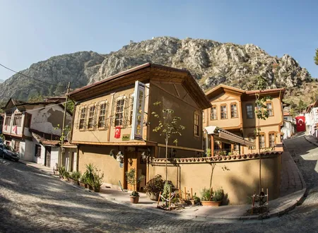
Çakallar is a small neighborhood in Amasya's central district and one of the best-known points from which the city can be seen from above. As one climbs from the Yeşilırmak valley toward the foot of Ferhat Mountain, the streets widen, the houses thin out and the pine forest thickens; at a certain point the citadel, the rock-cut tombs, the Yalıboyu mansions, the river and the bridges all appear in a single view. The city, which from below looks like a narrow corridor squeezed between two mountains, can be read from here as a whole. Today the place is known more for its view than for its housing, but its history of vineyards and pavilions is long. According to Hüseyin Hüsâmeddîn Yasar's Amasya Tarihi, it served as a hunting ground for princes, its springs were divided among the city's fountains, and its vineyards passed through the hands of a family descended from a judge and of people on whom a prince bestowed them as gifts. The name itself lives on alongside several different accounts.
Location and Geography
Hüsâmeddîn Yasar describes Çakallar as a pleasure ground and vineyard district known by that name, lying on the Yukarı Pazar side of Amasya, to the south. In his account it rises roughly two hundred meters above the ground level of the city, a mountain with a flat top, at the foot of the Pontic (Fon) range. Running from north to southeast, with high sides and a level middle, it is likened in shape to a long cradle. The flat part is called "Hamza Düzü." He writes that its air is wholesome, that every part of it is vineyard, and that each vineyard has a pavilion and, in one or two spots, an abundant flowing spring. In the spring months these slopes, known for their red roses and dark-spotted tulips, are in his view among the city's favorite places for an outing.
Hüsâmeddîn's book draws the boundary of Çakallar as follows. The same mountain is divided in two: the part lying east of the line of the road that passes in front of the Hoca Sultan Zaviyesi, above the Dârü's-Selâm Quarter, is called Çakallar, and the part to the west is called Karakaya. Karakaya extends about four kilometers, above the Gökmedrese Quarter, as far as Söngütlü Kaya near Zincirli Kaya. The İplik Çözen picnic ground below Köşk Kayası is counted as part of Çakallar, whereas Çanaklar below Kurt İni and Kaşık Pınarı above the Küpceğiz Quarter belong to Karakaya. The black rock that juts out toward the city is called "Burun" (the Nose), a name that also covers both sides of the projection. Karakaya's view is finer than that of the flat parts of Çakallar, and its vineyards are known for their cherries, their crocuses and their plentiful water.
The mountain called Ferhat is properly named Pont; the love story of Ferhat and Şirin has been attached to it, so that the same place has lived under two names. Hüsâmeddîn relays this story as a folk tale and treats the attribution of the five-meter-long grave on top of Ferhat Rock to "Ferhat the Lover" as an invention resting on the notion that people of old times were tall. Seen from the hilltop, the rock-cut tombs of the Pontic kings, the centuries-old mansions of Yalıboyu and the citadel fall into the same frame. Among the pines today there are a few hotels, guesthouses and tea gardens; these facilities have made the neighborhood a viewing and lodging point in the city's tourist life.
Origin of the Name
There are several separate accounts of where the name Çakallar comes from. The most widespread is the explanation repeated in tourist texts: in earlier times more jackals than people roamed these mountains, and the place was named accordingly. The account is plain and memorable, but no archival document supports it, and it is hard to tell apart from the folk etymologies so often found among place names.
The second account rests on a family name and belongs to Hüsâmeddîn Yasar. The author records that the descendants of Bedreddîn Mahmud Çelebi, known as "Çakal Kadı" (the Jackal Judge), were called the Çakalzâdes, and that this family served as trustees of the endowments of the Hacı Mahmud Çelebi Zaviyesi in İçerişehir. He argues that the vineyards were first called "Çakaloğulları Bağları" (the vineyards of the sons of Çakal), then by the shortened form "Çakallar Bağları," and in the end simply "Çakallar." Such contractions have many parallels in Turkish, and the author recalls that the Topaloğulları came to be called Topallar, the Ortakoğulları Ortaklar, and the Saloğulları Sallar. Explained in this way, the place name attaches not to an animal but to a family and to the vineyards the family owned.
The same book supplies a third detail, which suggests that Çakallar is a relatively late name. According to Hüsâmeddîn, before the name Çakallar appeared, up to roughly the 1000s of the Hijri calendar, these slopes appear in many documents as "Fernak Bağları" (the Fernak vineyards). His basis is a deed of sale dated 691 (1291-92): Kubay Hatun, of the line of Akboğa, sold this vineyard to Nâsırüddîn Ahmed bin Muhammed Pervâne Bey, the governor of Amasya who later became emir of Anatolia, and the document lists the boundaries of the property. The author also takes the phrase "er-riyâzi'l-Fernakiyye" (the Fernak gardens), used by Tâcî Beyzâde Sa'dî Çelebi of Amasya while praising a vineyard, as a trace of the same old name. He links Fernak to Pharnaces II, king of Pontus, and credits the king with building a town in this area. This last link rests on no document and is inferred from the similarity of the names. That the name Fernak was used for the vineyards before Çakallar is a separate claim, supported by the deed of sale and by other documents.
Which of the three accounts is right cannot be settled with the documents available. That the Çakalzâdes really owned vineyards on these slopes is supported, as will be seen below, by the records Hüsâmeddîn drew from the court registers; the jackal account is only an explanation passed from mouth to mouth.
Springs and Fountains
Çakallar holds a distinct place in the history of Amasya's drinking water. Hüsâmeddîn lists three famous springs that flow from this mountain and are known by the names of their patrons: Kaya Paşa Suyu, Üçler Suyu and Acem Ali Suyu. A fourth, Çırçır Suyu, comes from the Karakaya side. The waters most often mentioned in the city are those of Kaya Paşa and Acem Ali; Üçler Suyu was merged into Acem Ali Suyu, and Çırçır is small in volume and use.
Kaya Paşa Suyu rises on the Ermiş village plateau, about three kilometers beyond Çakallar, and flows to Çakallar. This water, formerly called "Torumtay Suyu," had its source cleaned and its channel repaired in 805 of the Hijri calendar (1402-03) by Torumtay Paşazâde Kaya Paşa, one of the emirs of Amasya, and it took the name Kaya Paşa Suyu for that reason. The pasha built fountains in fifteen places in the city, endowed the water as a waqf, and also founded a bath and a school. Under the terms of the endowment deed, fifteen Ottoman dirhams a year, or about thirty-three kuruş at the value of the author's time, were collected from every household the water reached; through a trustee drawn from the founder's line the channel and the source were kept clean, and whatever remained was spent on the school in the Kazancı Quarter. The income of the bath was likewise assigned to the school. When the trusteeship passed to the line of Rahtuvan Mehmed Paşa, one of the pasha's relatives, the bath and the school disappeared, and only the annual income of the water continued to be collected.
Acem Ali Suyu emerges east of Çakallar, on the stream near Zincirli Kaya, from beneath the rock called Söngütlü Kaya. The Nishapur-born merchant Hoca Hacı Acem Ali Ağa had its channel built in 873 (1468-69), opened fountains in thirteen places in the city and endowed the water. The water had earlier been in the control of the Üçler area and was bought from Hacı Mahmud Çelebi, and Acem Ali Ağa assigned it to the school he had founded in the Acem Ali Quarter. The waters flowing to his own quarter and to the surrounding quarters were called Acem Ali Suyu, while the water running to the Üçler Quarter kept its old name, although this too is a waqf of Acem Ali Ağa. In the time of the trustee Acem Alizâde Bâlî Bey and his children the school and the other charities were managed well; later, people who claimed to be relatives seized the trusteeship and collected the endowment's revenue without looking after the charities, so that, according to the author, benefactors had to step in with their help.
Çırçır Suyu rises on the skirts of Ferhat Mountain and flows to Karakaya. It was built around 625 of the Hijri calendar (1228) by Emir Alâeddîn Alîşîr et-Türkmânî and carried to the Gökmedrese Quarter and its surroundings. Although it is certain that it was first called "Alişîr Suyu," the reason it was later called "Çırçır" is not known; the author finds it more likely that the name is a corrupted form of "Alişîr." The water is ranked above all the waters of Amasya for its taste, and because it suits tea so well, tea drinkers use it. In the author's time its channel had gone uncleaned for a long while, so it ran very thinly.
The bringing of water from Çakallar to the city continued into the early twentieth century. According to Hüsâmeddîn, the estate of Yumuk Osmanzâde Ahmed Necîb Efendi passed to his son after his death in 1323 of the Hijri calendar, and the son, dying in 1325 (1907-08), bequeathed a third of his property to charity. Carrying out the will, his uncle Mehmed Hamdî Efendi, noting that there was no mountain water in the courtyard of the Sultan Bayezid Mosque and that the congregation suffered because the river water ran muddy for days, had a library built in front of the wall west of the school and, in front of it, a şadırvan (ablution fountain) for water brought specially from Çakallar. Work began in 1327 (1909) and was finished in 1329 (1911).
The Princes' Hunting Ground and Pavilions
In the historical memory of Çakallar, the princes hold the most prominent place. According to Hüsâmeddîn, the eastern side of Karakaya, because of its fine view, abundant water and clean air, was counted among the imperial estates of the Ottoman dynasty, and for as long as princes resided in Amasya this place was their "saydgâh," that is, their hunting ground. He observes, however, that the private properties of notables and emirs lay on the Karakaya side, and concludes that the area used for hunting was Çakallar alone.
The same author writes that during the years when Çelebi Sultan Mehmed governed in Amasya he had a tall pavilion built on Köşklü Kaya, now called Köşk Kayası, and that in the time of Prince Ahmed the "Köşklü Kaya Entertainments" were on the lips of the poets of the age and on the tongues of the common people. The ruins of the pavilion could still be seen in the author's time. The pavilion kept its former well-kept state in the time of Prince Mustafa, but after his sudden death the properties were divided and the name of the place changed. The author says the largest share fell to the Çakalzâdes, and that the place is known today by their name.
Şehzade Mustafa (Prince Mustafa) was the son of Süleyman the Magnificent and Mahidevran Sultan. From 1534 he served as governor of the sanjak of Saruhan, was appointed governor of the sanjak of Amasya on 16 June 1541 and moved to the sanjak of Konya in 1549. It is reported that the public and the army reacted when he was appointed to Amasya, and that Süleyman explained that he was sending the prince there for the security of the eastern lands and that his status as heir continued. He was a poet who wrote divan poetry under the pen name Muhlisî, and a calligrapher. According to Hüsâmeddîn, the eastern part of Çakallar had passed to Süleyman the Magnificent by inheritance; when Mustafa came to Amasya as governor he had a summer residence built here and lived in it for a time.
In these years the prince's education was overseen by Seyrek Muhyiddîn Efendi, then by Hayreddîn Hızır Efendi of Merzifon, and later by Sürûrî Efendi. Among poets, Hamdî, Zamânî and Edâyî attended his gatherings; young men such as Rüstem Beyzâde Gonca Keyvân, Lala Beyzâde Benefşe Ahmed, Gâzi Beyzâde Çiğdem Ali and Çakalzâde Gül Sinan Çelebi served as his companions. Hüsâmeddîn writes that the prince gave each of them, Gonca and Çiğdem, Çakalzâde Lale Ali Çelebi and Gül Çelebi, and his tutor Hamza Bey, a vineyard as a gift and as property. The place now called Hamza Düzü fell to the tutor Hamza Bey, and the section known as Goncalık, east of Hamza Düzü, to Gonca Bey. The author offers only as a guess that the place of Gül and Lale Çelebis lay west and south of Hamza Düzü.
The abundance of flower names among the place names is striking, and the author gives the reason as well: in those years the way to approach the prince was to write and present odes with the refrains benefşe (violet), gonca (rosebud), gül (rose) and lale (tulip). Many poets composed and presented odes and ghazals along these lines, and some of them are included in the Müntahabât-ı Eş'âr anthologies. This is a detail specific to Çakallar that is not repeated elsewhere in the city; yet apart from what Hüsâmeddîn relates, no archival plan of the summer residence has survived. Since no document is known on the exact location and structure of the residence or on which plot was given to whom, the account should be read as a narrative handed down by the local historical tradition; it cannot be treated as a documented building history.
The fate of the princes also left its mark on these slopes. Hüsâmeddîn writes that after Prince Bayezid, governor of Amasya, died in the trap of Kara Mustafa Paşa, all the places that had been the princes' hunting grounds were sold to emirs, notables and local grandees. He places the event in 967 of the Hijri calendar (1559-60); Prince Bayezid's death is generally dated to 1561 in Ottoman sources. The date of this sale concerning Çakallar therefore rests on contested ground, and the date given by the author is reported here as it stands.
The Çakalzâdes
The family that bears the name of Çakallar can be traced through the records Hüsâmeddîn extracted from the court registers. At the time of the sale the largest share fell to Çakalzâde Gül Sinan and Lale Ali Çelebi. Lale Ali Çelebi's portion passed to his son Lâlezâde Mehmed Çelebi and then to Sinan Çelebi. When Çakalzâde Sinan Paşa died in 1005 of the Hijri calendar (1596-97), having been dismissed from the governorship of Sivas, his share passed to his sons, the pashas Mahmud, Yusuf and Mehmed, and to his daughters. Mahmud Paşa died childless, so his portion was sold. Mehmed Paşa's share went to his son Ahmed Bey, and Yusuf Paşa's to his sons Ahmed Paşa and Mehmed Bey. When Ahmed Paşa died in 1076 (1665-66) his share passed to his daughters Münevvere and Fatma, and when Mehmed Bey's son Ahmed Bey died childless in 1091 (1680) his share passed to his female descendants and other heirs.
This chain matters because it shows how a district of vineyards changed hands over about a century and a half. The land passed first to a companion of the prince and his descendants, then to a family of pashas, and finally to women heirs, with the holding divided or sold in every generation. In the nine-to-twelve-volume part of the same work, the name of Çakaloğlu el-Hac Sinan Çelebi bin Mehmed Çelebi also appears; this notable, who died around 998 of the Hijri calendar (1589-90), is counted among the well-known men, and his vineyards at Çakallar are noted as famous. Whether the author takes him to be the same person as the Çakalzâde Sinan Çelebi mentioned earlier cannot be told from the book; the two records point to the same family circle, but no identity is claimed here.
Çakallar Stream and Its Floods
Within Amasya there are three streams: the Savakça, the Çakallar and the Karakaya. According to Hüsâmeddîn, the most fearsome of them is the Çakallar Stream, which descends to the river at Selağzı. It has caused many destructive disasters. In 1271 of the Hijri calendar (1854-55), a flood that followed a violent rainstorm demolished the bridges and houses along it, deposited one of the small dome stones on the dome of the Sinan Hamamı (Sinan Bath) west of Selağzı, and swept many animals, carts, timber and people into the river. The stone left on top of the bath was brought down only with great difficulty by many people.
The bath was built and endowed in 917 (1511-12) by Sinan Paşa, a former governor-general of Sivas and a freedman of Hızır Paşa. Because the mouth of the stream met the paved road along the river, the danger was constant, and in 1325 (1907-08) the district governor of Amasya, Ahmed Cevdet Bey, had a tunnel built under the paved road to separate the stream's mouth from the road. The account in Osman Fevzi Olcay's Amasya Hâtıraları looks at this neighborhood from another angle: the shops around Selağzı were roofed over, so no sun entered and they stayed dim and cool; to hide the floods coming down the road from Çakallar, Hamza Düzü, Kuba and Temenna, and the dirty water running into the city, the top of the stream had been covered with wooden and plank bridges, and along this cover stood shops, most of them coffeehouses and barbers.
Historical Events and Buildings Nearby
No documented, standing historical building has been identified within the boundaries of Çakallar itself; for this reason no mosque, bath or tomb should be ascribed to the neighborhood. On the other hand, the neighborhood lies right beside the best-known historical areas of Amasya. The mansions of Yalıboyu, the Hazeranlar Mansion and the Şehzadeler Museum (Museum of Princes) stand below, on the river bank. This museum holds a wax figure of Prince Mustafa, commissioned in 2005 by the Amasya Governorate and inspired by miniatures.
In his account of the Danishmendid conquest, Hüsâmeddîn mentions Çakallar once more, as a battlefield. According to the account, when Emir Ahmed Gazi reached the Amasya gorge in 467 of the Hijri calendar (1074-75), he divided his force into two columns: Ferhad Gazi's column was to descend from Fon Mountain onto Çakallar, and Süli Gazi's column from behind Kelkis Mountain onto the Şeyh Cûî vineyards. As Ferhad Gazi climbed Fon Mountain he was wounded by arrows and died a martyr, and was buried where he fell; Abdullah Gazi then took command, drove back the Byzantines and descended to Çakallar. The same author lists Fon Castle west of Çakallar and notes that it was destroyed by Abdullah Gazi in 468, its location being deduced from the description in the Târîh-i Âl-i Dânişmend. These are epic-type narratives relayed by the book and are not supported by archival documents.
The author also gives an entry from his own memories. While a student in Istanbul, he had heard that in 1312 (1894-95), in a vineyard southeast of Köşk Kayası in the lower parts of Çakallar, a blackish marble had come to light, inscribed in Kufic script "Yezîd bin el-Münzir bin Ebi'l-Hüseyn el-Antâkî." When he returned to Amasya he could not find the marble; although a few people said they had read the stone, he grieved that such a historical monument had been lost. According to Hüsâmeddîn, Yezîd bin el-Münzir was the emir who fell as a martyr in the Abbasid campaign into Byzantine lands in 169 (785-86); whether the stone really belonged to him cannot be verified because the stone has vanished.
The structure known as Halkalı Evliya, mentioned in local writings alongside Çakallar Hill, is a separate matter. It is a tomb of the baldachin type, said to date from the 15th century, resting on four stone columns, with a conical dome and open on three sides apart from its south face. An inscribed stone at the head of the grave and another set into the wall show that Sâru Hatun, daughter of Şadi Bey, a grandson of Şadgeldi Paşa, emir of Amasya, is buried here. A cellar is said to lie beneath the sarcophagus, with two stones covering its mouth, each with two iron rings at its edges; the building came to be called Halkalı Evliya (the Ringed Saint) because of the belief that children slow to walk would walk if their feet were caught in these rings on three Saturdays. The structure is described as lying on the border of the Çeribaşı Quarter near the Şehirüstü Quarter. Since it is unclear which neighborhood it belongs to, it is mentioned here as a place named together with the hill in the same local account, and it is not counted as belonging to Çakallar. The author who relates the account writes that in his childhood the neighborhood children sat among the columns of the tomb in the summer heat and climbed to Çakallar Hill over the rocks behind the houses.
Daily Life and Neighborhood Culture
Çakallar does not offer the texture of narrow streets and houses leaning on one another that the quarters of the city center do. It is a more open, wooded and quiet settlement. The facilities among the pines, the tea gardens and the viewpoint are among the places visitors to Amasya stop at. One travel writer advises climbing to Çakallar first, before beginning to tour the city, and making a plan there, since hours can pass at stops such as Amasya Castle, the Sultan Bayezid Mosque or the Bimarhane.
No detailed study has been found in open-access sources on the daily life, economic structure or social organization of the neighborhood's resident population; rather than invent information on this subject, the gap has been left as a gap.
Population and Change
Çakallar is a small neighborhood. According to a compilation that is said to rest on TÜİK/ADNKS data but describes itself as unofficial and informational, the population of the neighborhood has run as follows:
- 2012: 413
- 2013: 419
- 2014: 403
- 2015: 397
- 2016: 393
- 2017: 387
- 2018: 317
- 2019: 312
The series reached its highest value of 419 in 2013 and then declined gradually. The sharpest break comes in the move from 2017 to 2018: in one year the population fell by seventy people. The sources do not explain the reason for this drop, so no interpretation is offered. No verified figure has been given for more recent years.
Çakallar Today
Today Çakallar is the first stop for those who want to see Amasya from above. The city's historic center, the citadel and the mansions look like a scale model from here. Travel writers advise going up to the hill again in the evening after touring the city, to see the citadel and the mansions at the hour when the lights come on. The restored mansions of Yalıboyu, the Şehzadeler Museum and the river bank lie below; the eye looking down finds it easier to grasp their positions relative to one another.
Chronology
The number of events for this neighborhood that can be given a single certain date is small. Dates that come from local accounts are given together with their source.
1074-75: In the Danishmendid conquest account relayed by Hüsâmeddîn, Ferhad Gazi's column advances from Fon Mountain onto Çakallar (Hijri 467).
1291-92: The deed of sale showing that Kubay Hatun sold the vineyard known as "Fernak Bağları" to Nâsırüddîn Ahmed bin Muhammed Pervâne Bey, governor of Amasya (Hijri 691; the document is known through Hüsâmeddîn's report).
1402-03: Torumtay Paşazâde Kaya Paşa has the source of the water flowing to Çakallar cleaned and endows the water (Hijri 805).
1468-69: Acem Ali Ağa has the channel of the water rising east of Çakallar built and endows it (Hijri 873).
1511-12: The Sinan Hamamı is built at Selağzı (Hijri 917).
16 June 1541: Prince Mustafa is appointed governor of the sanjak of Amasya; the account of the summer residence at Çakallar is linked with this term of office.
1549: Prince Mustafa moves to the sanjak of Konya.
1559-60: According to Hüsâmeddîn, after the death of Prince Bayezid the hunting grounds at Çakallar are sold to notables (Hijri 967; Bayezid's death is given as 1561 in other sources).
1596-97: Çakalzâde Sinan Paşa dies; his share passes to his sons and daughters (Hijri 1005).
1854-55: A flood descending the Çakallar Stream destroys the bridges and houses at Selağzı (Hijri 1271).
1894-95: A marble with Kufic writing, said to have been found in a vineyard near Köşk Kayası, is heard of by Hüsâmeddîn and later disappears (Hijri 1312).
1907-08: District governor Ahmed Cevdet Bey builds the tunnel that separates the mouth of the stream from the paved road (Hijri 1325).
1909-11: The şadırvan in the courtyard of the Sultan Bayezid Mosque is built for water brought from Çakallar (Hijri 1327-1329).
2012-2019: The population of the neighborhood falls from 413 to 312.
Sources
Primary sources
- Hüseyin Hüsâmeddîn Yasar, Amasya Tarihi, volumes 1-4, Amasya Municipality, 2022, section on Çakallar and Karakaya (e-book pp. 82-83).
- Hüsâmeddîn Yasar, Amasya Tarihi, volumes 1-4, the Çakalzâdes and the explanation of the name Çakaloğulları (e-book pp. 84-85).
- Hüsâmeddîn Yasar, Amasya Tarihi, volumes 1-4, the Çakallar Stream and its floods (e-book p. 134); in the same work the Fernak Bağları document (e-book p. 275) and the Kaya Paşa, Acem Ali and Çırçır waters (e-book pp. 83-84).
- Hüsâmeddîn Yasar, Amasya Tarihi, volumes 9-12, entry on Çakaloğlu Sinan Çelebi (e-book p. 322); Osman Fevzi Olcay, Amasya Hâtıraları, Amasya Municipality Cultural Publications, sections on Selağzı and Kuba. amasya.bel.tr
- Kadir Çapanoğlu, "Şehr-i Amasya'da Halkalı Evliya ve Çakallar Tepesi," Yozgat Gazetesi (yozgatgazetesi.com), 11 July 2020.
Other sources
- Çakallar neighborhood population data, Merkez Mahalleleri Nüfusu Amasya, nufusu.com (TÜİK/ADNKS compilation, 2012-2019).
- "Şehzade Mustafa," Vikipedi (tr.wikipedia.org).
Online sources
- https://amasya.bel.tr/uploads/e-kitap/kitap/1-4/files/basic-html/page85.html
- https://amasya.bel.tr/uploads/e-kitap/kitap/1-4/files/basic-html/page134.html
- https://www.yozgatgazetesi.com/a-kadir-capanoglu/sehr-i-amasya-da-halkali-evliya-ve-cakallar-tepesi-139110.html
- https://www.nufusu.com/merkez-amasya-mahalleleri-nufusu
- https://tr.wikipedia.org/wiki/Şehzade_Mustafa