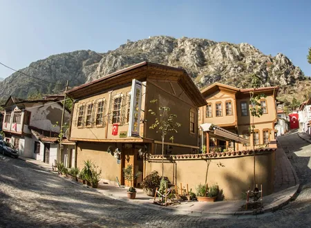
In official records it appears as the Bahçeleriçi Neighbourhood of Amasya's Central district, postal code 05200. It lies within the Dereboyu quarter of the city and counts among the most populous neighbourhoods of the central district. The name, now attached to a residential neighbourhood, appears in the book of the local historian Hüseyin Hüsâmeddîn Yasar as "Bahçeler İçi", the name of the belt of vineyards and gardens along the northern bank of the Yeşilırmak. No study has been found that documents the neighbourhood's founding, its first residents, or its place in the land and tax registers. The account below is therefore built from two layers: on one side, the gardens known by this name in older sources and the buildings around them; on the other, the position and population figures of the present-day neighbourhood. Whether the two coincide exactly cannot be said with certainty, since neighbourhood boundaries have shifted over time.
Origin of the Name
"Bahçeleriçi" is a plain Turkish compound: the inside of the gardens. In Amasya the phrase was used as the name of a locality long before it named a neighbourhood. Listing the vineyards that stretch along the Yeşilırmak, Hüsâmeddîn Yasar writes that from the head of Kuş Köprü onward, on the northern bank of the river, "Bahçeler İçi" comes first, followed by the vineyards called "Filingir, Firingir or Firenkler", and then the Ziyâre Vineyards. This ordering suggests that the name denoted a garden district before it denoted a settlement.
The same passage contains a piece of information about ownership. According to the author, Bahçeler İçi had formerly belonged to the dependencies of the palace and was sold to notables and private persons around 1000 in the Hijri calendar, that is, in the early 1590s. The text does not say which palace is meant, on what document the sale rested, or into how many parcels the gardens were divided. Even so, the sentence shows that the gardens were for a time dynastic or state property and later passed into private hands. This dispersal of garden ownership can be seen as the first link in the chain by which the locality was later broken up and turned into residential land, though no record describing that process has come to light.
In the contents pages of Amasya Hâtıraları, Osman Fevzi Olcay likewise lists the city's vineyards one by one, and among them gives a heading "Bahçeleriçi Mevki Bağları" (the vineyards of the Bahçeleriçi locality). The text under that heading is absent from the scan available to us, so we cannot report what Olcay wrote. The heading's position, beside the Frenkiler, Yenice and Kuz Kilise vineyards and before the Ters Dolap and Boğaz vineyards, does indicate that the locality was still recognised as a distinct vineyard district in the twentieth century.
Location and Geography
According to map and postal-code compilations, Bahçeleriçi lies in the Dereboyu quarter of Amasya's Central district, about one kilometre from the city centre. Its altitude is given as roughly 395 metres. The old core of Amasya runs along a narrow strip at the foot of Mount Harşena and beside the river; as the city spread beyond that strip, broad, level areas such as Dereboyu became residential districts.
In the older sources, by contrast, Bahçeler İçi is described as the vineyards to the north of the Şamlılar Neighbourhood. Describing the boundaries of Şamlılar, Hüsâmeddîn Yasar names the Yeşilırmak on the east, the cemetery on the west, the foot of the citadel on the south, and the "vineyards of Bahçeler İçi" on the north. In his section on madrasas he points to the same place: the Büyük Ağa Madrasa is described as a building in the Şamlılar Neighbourhood, beside the road, at the head of the vineyards known as Bahçeler İçi. Today the administrative boundary between Şamlar and Bahçeleriçi does not match this old description exactly. The encyclopaedia entry on the Kapı Ağası Madrasa places the building in the Şamlar Neighbourhood, while current guides place it in the Bahçeleriçi Neighbourhood. It is conceivable that the difference arises from neighbourhood boundaries redrawn later, but no document confirming this has been found.
The water of the area is the first reason these gardens existed. According to Hüsâmeddîn Yasar, the Tersakan River, a tributary of the Yeşilırmak, rises north of Lâdik, passes east of Havza and through the middle of Suluova, enters the city by Amasya's northern gorge, and joins the Yeşilırmak "above Bahçeler İçi". It took the name Tersakan, "the river that runs backwards", because it flows from north to south; when it swelled with spring water and did damage to its surroundings it was also called Deliçay, the "mad stream". The author adds that the mills, factories, vineyards and gardens on both banks drew on this stream. Near the point where the stream meets the river, on the Ziyâre road, stands an old bridge attributed to the Seljuk Sultan Mesud. That Bahçeler İçi lay close to the plain where two watercourses meet explains why this land was regarded as suited to gardens.
The Gülüs Meadow and the Name Cülüs
One of the neighbourhood's present streets bears the name Cülüs Caddesi. There is no direct document on the origin of this name, but Hüsâmeddîn Yasar records a very old place name in the same area. North of the Şamlar Cemetery, near the Tatar Neighbourhood, lies a locality called "Gülüs", whose northern part is meadow. The author says that the name appears in old documents in the same form as far back as the Hijri years 573, 635 and 727, and therefore existed before the Turks took Amasya. He adds that the vineyards to the north-east of Gülüs were called the "Taraput Vineyards", for the same reason.
He offers two possibilities for the origin of the name. The first is that it is a shortened form of Archelaus, a commander of the Pontic king Mithridates; the second is that it derives from the name of the Roman commander Lucullus, who defeated Mithridates and camped here. For "Taraput", he states plainly, he found no document, and no clue to support his own guess that it derives from the phrase "Tora Pont". The background to the second possibility is told elsewhere in the book: around 71 BC Lucullus entered the city through the northern gorge and camped on the meadow called "Gülüs", north of the gardens now known as "Bahçeler İçi". His soldiers did not destroy the city but fell to plundering.
Read together, these two passages show Bahçeler İçi and Gülüs as two names standing side by side in the same area. Whether the name of Cülüs Caddesi comes from this old locality name, or from the word "cülus", meaning accession to the throne, is not known. The same uncertainty applies to the Cülüstepe locality, where in 1919 Mustafa Kemal Pasha and his delegation are said to have been received on arriving in Amasya. The similarity of the names is striking, but no source has been found stating that this locality is the same place as the Gülüs meadow.
The Büyük Ağa Madrasa
The most important known building of Bahçeler İçi is the Büyük Ağa Madrasa, also called the Kapı Ağası Madrasa and the Medrese-i Hüseyniyye. It was built by Hüseyin Ağa, the chief of the palace gate (kapı ağası) of Bayezid II in Amasya. According to its inscription it dates from the Hijri year 894; since this year falls between the end of 1488 and the end of 1489, the sources give 1488 in some places and 1489 in others. Hüsâmeddîn Yasar transcribes the inscription and notes that the same wording is seen on the bedesten (covered market) built by Hüseyin Ağa. The encyclopaedia entry states that the inscription is no longer in place and was moved in pieces to the Amasya Museum.
In the author's year-by-year list of events, the same madrasa is mentioned among the events of the Hijri year 890, and it is said that in that year the madrasas of Hüseyin Ağa and of the lesser chief of the gate, Ayas Ağa, in the Şamlılar Neighbourhood, and Ayas Ağa's mosque, were completed. In the section that describes the madrasas one by one, however, the building is recorded as built in 894, and Ayas Pasha's mosque is tied to the Hijri year 900. The discrepancy seems to arise from the author's working with two separate compilations; since the date on the inscription is 894, the building is attributed to that year.
The madrasa has an octagonal plan, for which Ottoman madrasa architecture offers few parallels. Around the central octagonal courtyard, on each side, run pointed-arched porticoes carried on four piers, behind the porticoes lie domed cells, and on the south stands the domed lecture hall and prayer room, raised higher than the students' rooms. According to the encyclopaedia entry, the topography of the site played a part in producing this plan as much as the search for form, which is why the entrance door and the lecture hall do not lie on the same axis. The same plan, with small changes, was used again by Mimar Sinan in the Rüstem Pasha Madrasa in Istanbul, dated 1550. The building is laid in three courses of brick to one of stone, Bursa arches are used on the cell façade, and traces of malakârî decoration were seen in the plaster. In front of the madrasa stands a fountain in classical style; an empty marble panel sits above its arch, and it is thought that the fountain may also be one of Hüseyin Ağa's charitable works.
The madrasa's endowment was generous. Hüsâmeddîn Yasar lists among its revenues Amasya's well-known Bedesten. He writes that the whole of the bedesten was a valid endowment, that some of its shops later passed into private ownership, and that the middle bedesten was let for ten years to the "Abranusyan Brothers" but was not returned to the endowment for nearly twenty years, adding that this deserves investigation. The details of the endowment were treated in Semavi Eyice's 1978 article "Kapu Ağası Hüseyin Ağa'nın Vakıfları".
On the madrasa's rank the sources diverge. Hüsâmeddîn Yasar places the building among the "sixties" (altmışlı) madrasas, that is, those counted as first class in Amasya. According to the encyclopaedia entry, by contrast, in its first years the madrasa was of the "thirties" rank, and in 963 (1556) it stood among the "forties". The texts available to us do not explain the difference; a gradual rise in rank, or a ranking based on different criteria, comes to mind. Among its teachers the best known is Taşköprülü Musliheddin Efendi, who took up the post in the Hijri year 911 and was appointed to Istanbul in 918. According to the author, Koca Emir es-Seyyid İbrahim Efendi had served before him. The year-by-year list, however, names Ustaoğlu Tâceddîn İbrâhim Efendi as the first teacher; whether these two names belong to the same person or to successive holders is unclear.
In the following centuries the teaching post passed among a few families. When Kayyımzâde el-Hâc İsmâ'îl Efendi died in the Hijri year 1141, Ayıntâbî el-Hâc Kara Osmân Efendi succeeded him; in 1151 Hâfız Mehmed Efendi, in 1168 İbatsalı es-Seyyid Abdullah Efendi, in 1179 Halîl Efendi, and then es-Seyyid Mustafa Efendi and his son es-Seyyid Mehmed Emîn Efendi took the post. In 1193 came Şeyhzâde Abdullah Vecîh Efendi; after his death in 1218, his sons es-Seyyid Mehmed Şerîf, Abdurrahmân and Ahmed Rüşdî Efendi, then es-Seyyid eş-Şeyh Ahmed Rüşdî Efendi and his sons el-Hâc Hâfız Ali and İsmâ'îl Efendi follow. The last entry is that in 1312 Hacı Hâfız Ali Efendizâde el-Hâc Ali Efendi took over the teaching post. The name of the madrasa recurs in the volumes of Hüsâmeddîn Yasar's biographies of scholars as well; the traces of the scholars who taught in Bahçeler İçi can be followed that way.
When the author was preparing his book the building lay in ruins, and the sight distressed those who saw it. According to the encyclopaedia entry, the madrasa was abandoned after 1940, was damaged in the earthquake of 1942, and after 1965 the dome of the lecture hall collapsed and the front portico almost disappeared. Another source ties the damage to the earthquake of 1939. The Cultural Portal dates the repair to 1978 and the encyclopaedia entry to the 1980s; in the work carried out by the Directorate of Foundations, the lecture-hall dome, the portico arches and the columns were rebuilt and a fountain was placed in the middle of the courtyard. Today the madrasa is used as a Qur'an course.
Olcay too lists the madrasas of the area in Amasya Hâtıraları. Of the "Şamlar (Şamlılar) Madrasa" he writes that he does not know its founder, that the building carries no inscription or mark, and that in his own time its teacher was Ardahanlı Hoca Efendi. In a footnote he says that this madrasa "must be" the Büyük Ağa Madrasa built in 894 by Hüseyin Ağa, the chief of the gate of Bayezid II, and that the madrasa has been put in good repair. In the same section he also mentions the Gazanfer Ağa (Firuz Ağa) Madrasa, which stands in ruins to the right of the road parallel to the Şamlar Neighbourhood and is said to have been built in 768.
Buildings in the Surroundings
In Hüsâmeddîn Yasar's account, the surroundings of the Büyük Ağa Madrasa are mentioned together with the Şamlılar Neighbourhood and Kuş Köprü. Kuş Köprü stands in front of the Şamlılar Neighbourhood, opposite the Kumacık Bath; its span is so wide that the top looks flat, and it is a sturdy Turkish work in stone. Old records state that it was built by Hundî Hatun, said to be the mother of the Seljuk Sultan Mesud. Relying on the Ikdü'l-Cümân, the author notes that Mesud's mother was Orbay Hatun and concludes that Hundî Hatun must have been the sultan's daughter rather than his mother. In records of the Hijri year 768 the bridge appears as "Hundî Köprüsü" and later as "Kondı Köprüsü"; the name was later corrupted. At the head of Kuş Köprü, on the western bank of the stream, stands the small cell-like tomb of Müftüzâde el-Hâc Ömer Efendi, known as Dersi Tamâm. The author describes how it took him a seven-year investigation to identify the occupant of this grave, which has no inscription.
The name of the Şamlılar Neighbourhood also rests on a story of migration. According to Hüsâmeddîn Yasar, the area was formerly known as the Dânişmendli Estate, because Melik İsmâ'îl Dânişmendî had lived here. In the internal conflict of the Hijri year 791 between the Mamluk ruler of Egypt, Melik Eşref Şa'ban, and the Circassian Melik Zâhir Berkuk, the people of Damascus (Şamlılar) who supported Eşref were forced to leave their homes, and some of them took refuge in Amasya and settled in this neighbourhood. The author considers wrong Vâzıh Efendi's linking the name of the neighbourhood to a migration of the Umayyad period. It is recorded that the neighbourhood contained the mosque and tomb of Melik Gâzi Bey; when these buildings fell into ruin, the lesser chief of the gate, Ayas Pasha, had a stone mosque, a minaret, a madrasa and a school built in the Hijri year 900. The madrasa of Hüseyin Ağa is likewise counted among the buildings that revived the neighbourhood.
Near Bahçeler İçi, north of the Şamlar Cemetery, lies the Tatar Neighbourhood. According to Hüsâmeddîn Yasar, this neighbourhood was formed by Tatars settled in Amasya around the Hijri year 1295; although recorded in the official registers under the name "İhsâniye Neighbourhood", the name "Tatar Neighbourhood" prevailed among the people. The Tatars, described as industrious and devout, built a small mosque in the middle of the neighbourhood, and in 1316 Zileli Hacı Velizâde el-Hâc Hasan Efendi opened a school beside the mosque. Linked with the Gülüs meadow, this settlement appears as a neighbourhood that grew with immigrants at the end of the nineteenth century, just around the belt of gardens.
Buildings in Bahçeleriçi Today
Location compilations mention a Fatih Sultan Mehmet Mosque within the neighbourhood, on Cülüs Caddesi, with its address given as number 24 on the street. No verified source on the date of its construction or its founder has been found. Its name recalls that Mehmed the Conqueror stayed in Amasya in his princely days, but the connection of this with the founding of the mosque is undocumented.
The Faculty of Education of Amasya University is seen listed in one compilation under the Bahçeleriçi quarter; the same compilation also shows the faculty under the Akbilek Neighbourhood. This contradiction shows that the exact location needs to be verified from official sources, and the faculty has therefore not been counted among the neighbourhood's buildings.
Population and Change
The most reliable data we have on the neighbourhood's population is the annual series compiled from the results of TÜİK's Address-Based Population Registration System. According to this series, the neighbourhood's population in 2007 was 8,940; it rose to 9,201 in 2008 and to 9,956 in 2009. In 2010 a jump appears: the population rose to 11,902 and fell the following year to 10,617. It is possible that this sudden rise and fall stems from address-record adjustments or a boundary change rather than from migration, but since no explanation documents this, it can be mentioned only as a possible cause. As it is not known where the old garden belt falls within the neighbourhood's present boundaries, any link between this increase and the opening of gardens to housing cannot be established either.
After 2011 the population rose gradually: 10,879 in 2012, 11,122 in 2013, 11,253 in 2014, 11,293 in 2015 and 11,429 in 2016. The figure fell back to 11,232 in 2017, then rose to 11,406 in 2018 and 11,821 in 2019, the latter being the highest value since the 2010 jump. After 2019 a decline appears every year: 11,679 in 2020, 11,539 in 2021, 11,163 in 2022, 10,841 in 2023, 10,722 in 2024 and 10,419 in 2025. Between 2020 and 2025 a decrease of 1,260 people, about 10.8 per cent, was thus recorded.
According to the 2025 data, 5,028 of the population are men and 5,391 are women; women make up about 51.7 per cent. The cause of the decline in recent years cannot be read from these figures. Explanations such as the ageing of the housing stock, moves to newer housing, or young people leaving for larger cities come to mind, but none has been confirmed by research specific to the neighbourhood. Even so, with a population above ten thousand, Bahçeleriçi continues to be counted among the populous neighbourhoods of the central district.
Bahçeleriçi Today
Bahçeleriçi today is a residential neighbourhood. Apartment blocks, tradesmen's shops, schools, health facilities and people heading to work or school in the morning make up its everyday scene. Little remains of the old gardens, but the neighbourhood's name still carries that past. The octagonal courtyard and restored domes of the Büyük Ağa Madrasa stand as the only building that concretely shows the neighbourhood's documented history. Surveys of the Islamic court registers, land records and oral-history collections that would describe the neighbourhood from beginning to end have not yet been made; once they are, the details of the garden owners, the divided parcels and the successive migrations may also become known.
Chronology
c. 71 BC: According to Hüsâmeddîn Yasar, Lucullus enters Amasya through the northern gorge and camps on the Gülüs meadow, north of the gardens called "Bahçeler İçi".
1389 (Hijri 791): After internal conflict in Egypt, part of the Şamlılar take refuge in Amasya and settle in the Şamlılar Neighbourhood.
1488-1489 (Hijri 894): The chief of the gate, Hüseyin Ağa, has the Büyük Ağa Madrasa built at the head of the Bahçeler İçi vineyards.
1556 (Hijri 963): According to the encyclopaedia entry, the madrasa ranks among the "forties".
Early 1590s (c. Hijri 1000): Bahçeler İçi is taken out of palace ownership and sold to notables and private persons.
1894-1895 (Hijri 1312): Hacı Hâfız Ali Efendizâde el-Hâc Ali Efendi is appointed to teach at the madrasa.
1940-1942: The madrasa is abandoned and damaged in the earthquake.
1978-1980s: The madrasa is repaired by the Directorate of Foundations.
2007-2010: The neighbourhood's population rises from 8,940 to 11,902.
2019: The neighbourhood's population reaches 11,821, its highest value since 2010.
2025: According to ADNKS, the neighbourhood's population is 10,419 (5,028 men, 5,391 women).
Sources
Primary sources
- Hüseyin Hüsâmeddîn Yasar, Amasya Tarihi, vols. 1-4, Amasya Belediyesi Kültür Yayınları, 2022 (Bahçeler İçi vineyards, Tersakan River, Gülüs, Şamlılar and Tatar neighbourhoods, Kuş Köprü, Büyük Ağa Madrasa, the Lucullus account) amasya.bel.tr
- Hüseyin Hüsâmeddîn Yasar, Amasya Tarihi, vols. 9-12, Amasya Belediyesi Kültür Yayınları, 2022 (teachers of the Hüseyniyye Madrasa) amasya.bel.tr
- Osman Fevzi Olcay, Amasya Hâtıraları, Amasya Belediyesi Kültür Yayınları (list of vineyards, Şamlar Madrasa) amasya.bel.tr
Academic studies
- Semavi Eyice, "Kapu Ağası Hüseyin Ağa'nın Vakıfları", Edebiyat Fakültesi Araştırma Dergisi, no. 9 (1978), pp. 149-246
Official sources
- Republic of Türkiye Ministry of Culture and Tourism, Cultural Portal, "Kapı Ağası Medresesi - Amasya"
Books
- Gülay Burgaz, "Kapı Ağası Medresesi", TDV İslâm Ansiklopedisi, vol. 24, Istanbul 2001, pp. 342-343 islamansiklopedisi.org.tr
Other sources
- nufusune.com, "Bahçeleriçi Mahallesi Nüfusu, Merkez Amasya" (ADNKS population series 2007-2025) nufusune.com
- haritatr.com, "Bahçeleriçi Mahallesi Haritası Amasya Merkez" (location, altitude)
Online sources