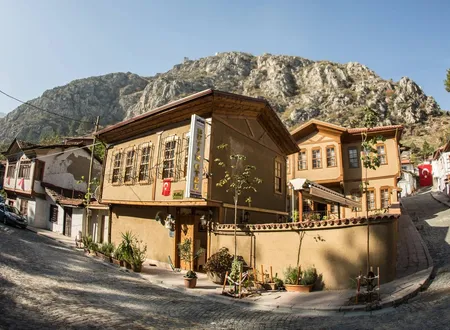
Among the administrative neighbourhoods of Amasya's central district, Demetevler is one of the least familiar names. Official lists and postal-code records also give it as "Demet Evler Mahallesi". It should not be confused with the district of the same name in Ankara; the subject here is the neighbourhood in the city on the Yeşilırmak. The documents available do not illuminate its past well enough to support a long narrative. Rather than make a place of little recorded detail look richer than it is, it is better to keep what is known apart from what is not. The account therefore places the neighbourhood first within the geography of the city, and then follows the traces left by its name and its figures.
Origin of the Name
The name appears to combine the Turkish words "demet" (bunch, bundle) and "ev" (house), and at first glance suggests houses built together like a bunch. Even so, that association does not show that the name arose from a housing cooperative, a building society or some other event; no reliable explanation of how the name was given could be found in the open sources consulted, and no definitive document has been found. Since it could not be verified whether the name appears in Hüseyin Hüsameddin Yasar's Amasya Tarihi, no history reaching back to the Ottoman period is attributed to the neighbourhood. The name may well derive from a relatively recent housing designation, but this is a guess and cannot count as a documented fact. Many of the older neighbourhood names of Amasya come from a mosque, a lodge or a family; a plain, descriptive name such as Demetevler lies outside that tradition and points to a more recent habit of naming.
Location and Surroundings
Amasya lies in the narrow valley opened by the Yeşilırmak, between the high cliffs of the Harşena mountains to the north and the Ferhat mountains to the south. The river runs through the city from end to end, and the neighbourhoods of the central district are scattered across different stretches of the valley and sometimes across the surrounding slopes and flats. The city spread along this narrow bed first toward both banks, then toward the widening parts of the valley and the slopes. Demetevler lies within this larger geography. The approximate position given in neighbourhood guides falls slightly southwest of the district centre; this is a rough inference from map data and does not suffice to describe which part of the valley it occupies or to detail its immediate surroundings. Its area is given as about 0.61 square kilometres, a figure that places the neighbourhood among the limited-area units of Amasya. The area of Çakallar Neighbourhood is roughly three times as large (1.697 km²), while some others, such as Pirinççi, are much smaller (0.078 km²).
Historic Buildings
There is no reliable record of a registered mosque, bathhouse, tomb or historic house within Demetevler. Amasya's well-known monuments, namely the Yalıboyu Houses, Harşena Castle, the royal rock-cut tombs and the Ottoman complexes, lie within the boundaries of other neighbourhoods and should not be credited to this one. Historical writing tends to follow the places where monuments stand; a neighbourhood without one therefore remains in the background of the sources. The neighbourhood has a history of its own, but it has not yet been written down, and until more documents appear, what can be said of Demetevler will remain limited compared with the rest of the city.
Population and Change
The neighbourhood's population has stood at a little over two hundred for years, which makes for a quiet picture beside the crowded neighbourhoods of Amasya. The series gives one value for each year from 2012 to 2019. The annual figures compiled from the TurkStat address-based population registration system are as follows:
- 2012: 283
- 2013: 287
- 2014: 304
- 2015: 287
- 2016: 270
- 2017: 260
- 2018: 259
- 2019: 241
A compilation based on 2023 TurkStat data gives the population as 260. The series peaked at 304 in 2014, fell to 241 by 2019 and rose again to 260 in the 2023 figures. A fall of 63 people over five years amounts, at this scale, to a decline of more than twenty percent, but the sources do not explain the fluctuation. A change in neighbourhood boundaries, turnover in housing or merely an update of address records are among many conceivable explanations, none of them documented. For this reason the figures are reported as they stand.
A comparison gives a sense of scale. The 2025 population of Amasya's central district is given as 151,433; Demetevler, with about 260 people, is less than 0.2 percent of it. The population of Şeyhcui Neighbourhood in the same district was 23,145 in 2019, about eighty-nine times that of Demetevler. About 260 people on 0.61 square kilometres give a density of some four hundred people per square kilometre. In a district of nearly forty neighbourhoods, a few others such as Nergiz and Saraycık are smaller by population; Demetevler stands in the lower half of this ranking.
Demetevler Today
Today Demetevler is a sparsely populated, quiet neighbourhood on the administrative list of Amasya's central district; away from the busy city centre along the river, it can be said to offer a calmer settlement pattern, though this too is no more than a general impression. The appearance of detached-house listings in property advertisements suggests that at least part of the housing stock consists of houses, but this is only a general impression and does not rest on a street-level finding. No significant information could be found in open sources about the neighbourhood's headman's office, school, mosque or local customs. These headings are left blank because nothing is known. Municipal archives, land and zoning records or the accounts of residents may fill this gap in the future.
Chronology
No documented date of founding, naming or merger has been found for this neighbourhood. The only dated data available are population records (2012-2019 and 2023) and are given above.
Bibliography
Other sources
- nufusu.com, "Merkez Mahalleleri Nüfusu, Amasya" (TurkStat/ADNKS series 2012-2019)
- nufusu.com, "Merkez Nüfusu, Amasya" (district population, 2025)
- Atlasbig, "Amasya Amasya Merkez'in Mahalleleri, Nüfus Bilgileri, Haritalar ve İstatistikler" (2023 TurkStat data, area)
- sehirsorgula.com, "Amasya Merkez Mahalleleri"
- Sabah, "Amasya Merkez Demet Evler Mah Posta Kodu"
Online sources