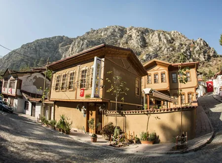
Officially registered as Göllü Bağları Mahallesi but usually written and spoken as a single word, Göllübağları, the neighbourhood lies at the northern entrance to the Amasya Merkez district, beside the road to Samsun. It stands in the shadow of the Yalıboyu houses, the royal rock tombs of Harşena and the Sultan Bayezid Complex, outside the city's usual tourist route. A traveller coming from Samsun follows the valley of the Tersakan and passes between the neighbourhood's houses just before entering the city; the better-known buildings begin farther on, inside the gorge. Little historical documentation has been written about it as a result. What is known gathers around its place among the old vineyard names, the past of the city's northern gorge, the history and floods of the stream that feeds it, a Seljuk bridge on the Ziyare road, its population records and an environmental problem that has repeatedly reached the local press in recent years.
Origin of the Name
The name is built from two words: göllü and bağlar. Göllü means a place with a lake, or one associated with a lake; bağlar refers to vineyards and orchards. Gardening and viticulture have long been part of life in the Yeşilırmak valley, and Amasya has been known for its fruit for centuries. It is therefore natural to suppose that the neighbourhood was once known as a vineyard and garden area. Indeed, this plain at the city's northern end, close to both river and stream, lies in a position that could be counted favourable ground for vineyards and gardens.
No source, however, explains which lake is meant, or when and by what process the phrase became the name of a neighbourhood. On this point no definite document has been found. The reading above is only an inference from the ordinary meaning of the words and should not be taken as an etymology confirmed by local historiography. One further name should not be confused with this one: a village called Göllü exists near Kırşehir, and its history has no connection with this neighbourhood.
Location and Geography
The neighbourhood lies in the north of Amasya, close to the point where two watercourses meet; the valley of the Yeşilırmak to the east, the city's northern gorge to the south and the road running toward the Suluova plain to the north frame its position. The Tersakan Stream rises in Lake Ladik and flows first west, then south, then east before reaching the Yeşilırmak; it is said to have taken its name ("Tersakan", roughly "flowing backwards") from these changing directions. After joining the Gümüşsuyu Creek near Suluova, it empties into the Yeşilırmak north of Amasya. The stream is 91.4 kilometres long, drains a basin of 2,684 square kilometres, and carries the Yedikır Dam, built for irrigation. As irrigation water it falls into the first class for alkalinity and the second class for salinity, with an average pH of 8.5.
The Samsun-Amasya highway runs within the neighbourhood's boundaries, and one of its streets is Alparslan Türkeş Boulevard. Amasya sits on the land route that links inland Anatolia to the port of Samsun, and the railway connecting the city to Samsun opened in 1930. The road ties the neighbourhood to the rest of the city and also to the port on the coast. The neighbourhood contains everyday buildings such as the Nur Mosque and the private Kutlubey College. These are listed in map and address directories, and no information on their construction dates could be found.
The Northern Gorge and the Old Names Around It
To understand the historical setting of Göllübağları one has to know the pass in which it sits. Hüseyin Hüsameddin Yasar writes that Amasya is enclosed by the Pontic ranges to the south, the Canik and Harşena ranges to the north, and the Şeyh Cui-Kelkis and Karaman ranges to the west, and that it lies open only to the south-west, the north-east and part of the north. These openings are called the Amasya Gorge: the north-eastern gorge faces Sonusa and Taşova, the south-western one Derbend-Çalan, and the northern one Arguma and Suluova. The author likens the city, with these three great gates, to a lofty pavilion or a well-fortified palace. By his measure the northern gorge is about ten kilometres long and the southern one about four (Hüsameddin, Amasya Tarihi, volumes 1-4, e-book p. 76). It is through this northern gorge that the Tersakan descends from Suluova to the city and the Samsun road follows it, and Göllübağları stands near the point where the gorge opens toward the town.
At the Suluova end of the gorge are the slight remains of a structure Hüsameddin calls Arguma Castle. According to him the castle was built in two parts facing each other on either side of the gorge, and both the gorge and the broad plain in front of it appear in old records under the name Arguma (volumes 1-4, e-book p. 92). The same author relates that the Roman commander Lucullus, in his campaign against King Mithridates of Pontus, entered Amasya through this northern gorge and encamped on the Gülüs meadow north of the gardens now known as Bahçeleriçi (volumes 1-4, e-book p. 278). This account is Hüsameddin's attempt to map the ancient sources onto local geography and its details should not be treated as settled; even so, it suggests that the northern entrance was, across the ages, the first halting place of armies and caravans heading for the city.
Gülüs is a place name that survived for a long time on the plain just south of the neighbourhood. Describing the Tatar Quarter north of the Şamlar Cemetery, with the paved road on its east, founded by Tatars who settled there after 1295 (1878) and entered in official records as İhsaniye, Hüsameddin says that the meadow covering the northern part of this quarter had long been known as Gülüs. In his view the name appears unchanged in records dated 727, 635 and 573, and therefore predates the conquest. The vineyards north-east of Gülüs were called the Taraput vineyards, a name he also believes to be older than the conquest. Hüsameddin suggests that Gülüs may be a corruption of the name of Archelaus, Mithridates' commander, or of Lucullus (volumes 1-4, e-book p. 113). This is an exercise in folk etymology. The Dirabut vineyards, which follow Ayvasıl in Olcay's list of vineyards, are probably the same place as Hüsameddin's Taraput vineyards; the resemblance between the two spellings is striking, but no record confirming the identification has been found.
The religious memory of the northern gorge is also bound up with the vineyards. Hüsameddin writes that each side of Amasya has the resting place of a holy fool, with Tekirdağlı Baba in the northern gorge and Has Baba in the southern one (volumes 1-4, e-book p. 134). The Tomb of Tekirdağlı Baba, which he lists among the city's tombs, stands on a ridge above the vineyards on the western side of the gorge facing Suluova; the man buried there is known as a contemporary of İydîzâde Âkif Mustafa Efendi, and many marvels are attributed to him (volumes 1-4, e-book p. 138). Osman Fevzi Olcay, listing the graves of holy men in Amasya, places the grave of Havâce-i Tekirdağî opposite the Köle Mezarı vineyards. In Olcay's list the Köle Mezarı vineyards come immediately before Göllü Bağları. It is reasonable to think that the two records describe the same person, which would also show that the vineyards of the northern gorge formed a continuous strip of neighbours. The tomb's position in terms of today's neighbourhood boundaries could not be established.
Göllü Bağları Among the Vineyard Names
The firmest trace of the name in the written record lies in Amasya's vineyard order. Hüsameddin describes the vineyards on both banks of the Yeşilırmak as a long strip stretching eighteen hours' distance along the river, with the city standing exactly at its middle. The vineyards were named after their locations and their owners. On the south bank, going west from the Sultan Bayezid Mosque, the İnehan, Yörgüç Paşa, Hacılar Meydanı, Ferhad Arası and Çalan Köprü vineyards are listed; going east from the Bayezid Paşa Mosque come the Ahır Önü and Ayavasıl vineyards, with the Kirazlıdere vineyards lying to their south. On the north bank, from the head of Kuş Köprü onward, Bahçeler İçi, then Firingir or Firenkler, and then the Ziyare vineyards are the best known (Hüsameddin, Amasya Tarihi, volumes 1-4, pp. 88-89). Göllü Bağları does not appear in this survey.
The name does appear in Osman Fevzi Olcay's Amasya Hâtıraları. The table of contents of Olcay's book gathers the vineyards under a separate heading: the Ayvasıl, Dirabut, Frenkiller, Yenice, Kuz Kilise, Bahçeleriçi Mevki, Ters Dolap, Boğaz, Gezirlik and Köle Mezarı vineyards are followed by Göllü Bağları, and then by the Değirmenaltı Mevkii, Ziğere (Ziyere) and Aynalı Mağara Önü vineyards. That Göllü Bağları sits in a list that records Amasya's vineyard localities shows that the name belonged to a vineyard locality before it belonged to a neighbourhood. Its place in the same group as the Boğaz, Köle Mezarı and Ziğere vineyards also suggests that it was part of the vineyard strip between the northern gorge and the Ziyare road. The neighbourhood name most probably arose when this older vineyard name passed to the settlement, but no document that says so outright has been found.
Olcay also touches on the place of these vineyards in everyday life while describing the elders of his neighbourhood. He writes that Hacı Ali Hafız Ağa, of the Dubaracıoğlu family, was a generous bath-keeper who ran the Sinan Bath at Selağzı and the Mustafa Bey Bath in front of the asylum. After the evening meal Hafız Ağa would sit on the bench in front of his house with his water pipe, and his neighbours would come and be served coffee. He was also a good hunter: he would ride out with his dog, some days to Göllü Bağları and some days to the Köle Mezarı vineyards, and return cheerfully with partridge, woodcock and hare tied behind the saddle. A small anecdote, this record shows that in the Amasya of Olcay's childhood and youth Göllü Bağları was known as an open, vineyard-covered place outside the city, far enough to be reached on horseback for a day's hunting. Olcay is a memoirist of the baths, markets and mansions of those years, and he gives Göllü Bağları no section of its own.
Read together, the two authors indicate that the ground on which the name rests was a vineyard locality in recent times. No record reaching back to the Seljuk or early Ottoman periods, to the land survey registers or to the Islamic court registers has been found in this work, and no detail about the neighbourhood has been written for those periods.
The Tersakan's History and the Neighbourhood
The main historical presence on the neighbourhood's northern edge is the Tersakan Stream. Hüsameddin counts it among Amasya's three rivers and departs from today's common explanation when he accounts for its name: according to him the river is called Tersakan, "reverse-flowing", because it runs from north to south. Present-day compilations, by contrast, say that the name comes from its course after leaving Lake Ladik, turning west, then south, then east. The two accounts do not agree in detail, though they meet where each derives the name from a flow that runs against the expected direction. Hüsameddin adds that the river is recorded in the work Ahbâru'l-İbâd as en-Nehrü'l-Maklûb, the "reversed river", and that the name was current among the Turks from the time of the conquest. In older documents it is entered as Astifonos and İstiyotos. Elsewhere, narrating the wars between Rome and the kingdom of Pontus, the same author proposes that the river Lykos should be the present Tersakan; this identification is his own inference and not settled knowledge (Hüsameddin, volumes 1-4, pp. 95-96 and 167-168).
The story of the stream and of the vineyards on its banks cannot be separated from the neighbourhood. Hüsameddin's description also fixes the neighbourhood's position. The stream rises north of Ladik, passes east of Havza and through the middle of Suluova, enters the northern gorge of Amasya and joins the Yeşilırmak above Bahçeler İçi. Its water falls in summer and rises in spring; because it overflowed and caused damage, it was also called Deliçay, "the mad stream". Hüsameddin writes that many factories, mills, vineyards and gardens on its two banks drew on this water. Given that Göllü Bağları lies close to where the Tersakan joins the Yeşilırmak, it is plausible that the stream played a part in watering the old vineyards, though no record documents this. The names Ters Dolap ("reverse waterwheel") and Değirmenaltı ("below the mill") in Olcay's vineyard list are also reminders of how common waterwheels and mills once were along this strip of vineyards on the banks of stream and river; it is not known, however, which watercourse the installations behind these names stood on.
The Ziyare Bridge and Hundî Sultan Hatun
Near the stream's mouth, on the Ziyare road, stands a bridge that Hüsameddin describes. In the geographical section of Amasya Tarihi he writes that it was built by the Seljuk Sultan Mesud, as its old name, the Mesud Bridge, and its architecture show; that it is very sturdy and proclaims itself a Seljuk work on every side; and that in the span of its arch it resembles Kuş Köprü but is more graceful and finely made (volumes 1-4, p. 96). Here he does not say which Seljuk sultan named Mesud is meant. As the second old bridge on the Tersakan he names the single-arched Çeltek Bridge at the far end of Suluova, where the Amasya road and the Merzifon road part.
In the same author's biographical volumes, however, the building of the bridge is credited to someone else. According to Hüsameddin, Hundî Sultan Hatun was the daughter of the Seljuk Sultan İzzeddin Keykâvus; as the wife of Nasıreddin Mehmed Bey, a descendant of the Amasya governor Seyfeddin Torumtay, she lived in Amasya and was held in high honour during the reign of her brother Sultan Gıyaseddin Mesud. Hundî Sultan Hatun had the bridge known in the city as Kuşköprü built, together with another bridge over the reverse-flowing river on the Ziyare road, and from the revenue of the large estates granted to her, known as Simre-i Havza, she also had the Çeltik Bridge built. When her brother Sultan Mesud died in Kayseri in 704 (1304-1305), she had his body brought to Amasya, buried it within the same estate and raised a tomb over it (Hüsameddin, Amasya Tarihi, volumes 9-12, e-book p. 146).
At first sight the two records conflict: in the geographical section the founder of the bridge is Sultan Mesud, in the biographical section his sister Hundî Sultan Hatun. Supposing that the name Mesud Bridge survived because the structure went up during the reign of Gıyaseddin Mesud would reconcile the two accounts; but this is an interpretation, and Hüsameddin himself offers no such explanation. Moreover, while the geographical section says that the founder of the Çeltek Bridge is unknown, the biographical section attributes this bridge too to Hundî Sultan Hatun. The discrepancy between the sources remains unresolved. In present-day introductions to Amasya's bridges, the bridge attributed to the Seljuk Sultan Mesud I is the İstasyon Bridge on the Yeşilırmak, and that structure should not be confused with the bridge on the Ziyare road. Whether the Ziyare Bridge still stands, and its exact position in terms of today's neighbourhood boundaries, could not be established.
Floods and the Deliçay
The name Deliçay recorded by Hüsameddin shows that the Tersakan was not always a quiet neighbour for the vineyards and houses at the northern entrance. In Hüsameddin's chronicle of Amasya, a disaster in which the city's watercourses all overflowed together is described in detail. On the twelfth day of Shawwal in the year 1088 (late 1677), violent rain began over Amasya and its surroundings and lasted three days. Floods coming down the creeks wrecked the houses along their banks, carried off several people along with the debris, and destroyed the crops and produce in the vineyards and fields. The Yeşilırmak then burst its banks and turned the squares and the heart of the city into something like a sea; the Sultan Bayezid Mosque was flooded, and the Hacı İlyas, Eski Kethüdâ, Devehâne and Köprübaşı quarters and the riverbanks of İçerişehir were left in ruins. With the Çekerek and Deliçay rivers also in spate, the whole country took on the terror of a deluge. On the strength of a detailed legal report submitted by Mahmud Efendi, the deputy judge of Amasya, an imperial decree was issued exempting the poor who had suffered from these calamities from that year's taxes (Hüsameddin, volumes 1-4, e-book p. 598). Whether the Deliçay here is the Tersakan or a separate stream known in Amasya by the same name is not certain; Hüsameddin writes that the Tersakan was also called Deliçay, but Republican-era records count the Tersakan and the Deliçay as separate watercourses. Nor does the text mention damage around Göllü Bağları specifically.
The floods continued in the Republican period. According to Mehmet Dümen's study, based on archival documents and national newspaper reports, Amasya and its surroundings were struck again and again by floods and inundations between 1930 and 1960; together with the Yeşilırmak, the Tersakan, Çekerek, Deliçay and Kelkit streams at times overflowed their beds, sometimes causing destruction all at once. Almost every spring the waters, swollen by snowmelt and rain, turned fruit and vegetable gardens and fields into marshland, and malaria spread across land that stayed under water for long periods. During the floods the city's road links came close to being cut, the railway station was submerged, and traffic on the Samsun-Amasya-Sivas railway was interrupted. The study's abstract gives no neighbourhood-by-neighbourhood detail; but since the Samsun road, the railway and the mouth of the Tersakan meet at the same northern entrance, the floods of these years clearly concerned the stretch where present-day Göllübağları stands.
Population and Change
According to a population website that compiles data from the address-based population registration system, the neighbourhood's population between 2012 and 2019 developed as follows:
- 2012: 740
- 2013: 795
- 2014: 817
- 2015: 795
- 2016: 850
- 2017: 907
- 2018: 1,095
- 2019: 1,117
The eight-year course of a small neighbourhood gives the impression of a city widening slowly northward. The figures show an increase of roughly fifty-one percent over eight years. Growth is moderate in the early years, with a small decline in 2015. The marked jump comes between 2017 and 2018, when the population rises from 907 to 1,095, an increase of about 190 people in a single year. No record explaining the jump has been found; new housing, a change in neighbourhood boundaries or a change in registration practice may come to mind, but none of these is verified information. Figures on compilation sites are not official publications and are given for information only.
A more recent real-estate market compilation, ranking the neighbourhoods of Amasya Merkez by population, gives 2,027 people for Göllü Bağları; the same table shows the 30-44 age group and university graduates as prominent in the neighbourhood, with an average of 2.92 people per household. The compilation does not state which year's data it uses, and it is not an official statistic. If the figure is correct, the neighbourhood's population nearly doubled after 2019; it has not been possible to confirm a rise of this scale from an official source.
Pollution in the Tersakan
The subject for which the neighbourhood's name has been heard most often in recent years is pollution in the Tersakan Stream. The problem is not new. An algae study carried out at Ondokuz Mayıs University by Gonca Baş Pelit, with monthly samples taken between June 2007 and May 2008, identified eighty-two taxa in the stream and found that, in both its physicochemical properties and its phytoplankton species, the Tersakan was under the influence of organic pollution from domestic waste and discharges, moving from a eutrophic toward a hypertrophic state. The thesis abstract does not give the locations of the sampling stations, so it is not known whether the measurements covered the stretch at the mouth next to the neighbourhood.
In January 2022, when dry seasons had brought the water level down to the bottom, white foam formed on the stream, and teams from the Provincial Directorate of Environment, Urbanisation and Climate Change took water samples. The foaming was seen especially in the section passing through Boğazköy, where an elderly resident said that whenever the factory was washed out the water flowed like this for months, and that the stream had been in this state for fifty years. The headman (muhtar) of Göllübağları, Sezai Çınarcı, said that the foaming could also be seen where the Tersakan joins the Yeşilırmak, that the heavy smell and foam came from factory and animal waste from the Suluova area accumulating there, and asked for a treatment plant to be built at the Boğazköy locality. His words as quoted in another report are sharper: the water they had long known as the Tersakan River, he says, has become a creek in which nothing lives, where the waste from the Suluova and Çeltek areas meets. The description of the Tersakan in the same report as Turkey's only river that flows backwards is a set phrase of the local press, not a scientific classification.
In August 2024 mass fish deaths were seen, this time at the point where the Yeşilırmak meets the Tersakan, and officials from the Directorate of Environment, Urbanisation and Climate Change and the Provincial Directorate of Agriculture and Forestry took samples from the water and the fish. A veterinarian quoted in the report said that dead and stunned fish must not be eaten, that the gills of the fish in the Yeşilırmak had turned dark brown, close to black, that careless fertilising at that season added to domestic and industrial waste, and that the low flow made the pollution highly concentrated. No statement on the results of the investigation could be found.
Another report carried by the local press in November 2024 says that, with reduced rainfall, the stream's water level had fallen close to exhaustion, and that animal waste, sewage and factory effluent discharged into the creeks feeding the stream around Suluova had accumulated and produced a foul smell. Residents protested the pollution by holding their noses on the bridge, saying that the Havza section of the streambed was clean while the stretch from Suluova to the city centre was polluted. The headman Sezai Çınarcı said that the pollution on the water surface could be seen all the way from Suluova to the confluence with the Yeşilırmak, and that the smell, endured for more than ten years, also affected the neighbouring Bahçeleriçi and 55 Evler neighbourhoods. Çınarcı named factory and livestock waste from Suluova as the main cause and said residents again wanted a treatment plant built at the Boğazköy locality. Residents recalled that the stream was once a place where people swam, drank the water and fished, that even standing on its bank is now hard, and that they cannot go out on their balconies. These statements are personal testimony; the reports contain no laboratory data on the measured level of pollution.
Göllübağları Today
Today the neighbourhood, at the entrance to the city, is both a residential area and a settlement on a transport corridor. Most of the old vineyard plots seem now to have merged into a fabric of summer gardens and housing; even so, the stream bank and the breadth where plain and valley meet still carry a trace of the open, green appearance the name calls to mind. As the city has grown northward, the neighbourhood has also become home to some provincial institutions. The Provincial Directorate of Environment, Urbanisation and Climate Change gives its address as Defne Street, Göllübağları; the directorate whose teams take samples from the Tersakan thus sits in the neighbourhood beside the stream's mouth. The Provincial Gendarmerie Command likewise gives its address as Alparslan Türkeş Boulevard, Göllübağları.
Where the built-up area ends, the neighbourhood backs onto wooded slopes. In footage reported by the local press in January 2026, a fox, thought to be struggling to find food in winter, came down from the woods in the evening and wandered the streets of Göllübağları. A small incident, it is a reminder that part of the open vineyard country where, in Olcay's account, Hafız Ağa went after partridge and hare still lies at the neighbourhood's edge. And because the neighbourhood lies next to the mouth where the Tersakan joins the Yeşilırmak, the sight and smell of the stream's pollution are felt most strongly along this bank.
Chronology
c. 71 BC: According to Hüsameddin, the Roman commander Lucullus enters Amasya through the northern gorge and encamps on the Gülüs meadow.
704 (1304-1305): Sultan Gıyaseddin Mesud, brother of Hundî Sultan Hatun, who is recorded as having built Kuşköprü and the bridge on the Ziyare road, dies in Kayseri and is brought to Amasya for burial.
1088 (1677): After three days of rain the Yeşilırmak, Çekerek and Deliçay overflow; houses, vineyards and fields in Amasya are damaged.
1930: The Samsun-Amasya railway line enters service.
1930-1960: Amasya's watercourses, the Tersakan among them, overflow repeatedly; gardens and fields turn to marsh.
2007-2008: An algae study of the Tersakan Stream finds it under the influence of organic pollution from domestic waste.
2012-2019: The neighbourhood's population rises from 740 to 1,117.
January 2022: Foaming appears on the Tersakan Stream; the neighbourhood headman calls for a treatment plant at Boğazköy.
August 2024: Mass fish deaths are seen where the Yeşilırmak meets the Tersakan.
November 2024: Pollution and odour in the Tersakan Stream reach the local press through the protest of the neighbourhood's residents.
Sources
Primary sources
- Hüseyin Hüsameddin Yasar, Amasya Tarihi, Amasya Belediyesi, 2022 (volumes 1-4, pp. 88-89, 95-96, 167-168; e-book pp. 76, 92, 113, 134, 138, 278, 598)
- Hüseyin Hüsameddin Yasar, Amasya Tarihi, Amasya Belediyesi Kültür Yayınları, 2022 (volumes 9-12, e-book p. 146, entry on Hundî Sultan Hatun)
- Osman Fevzi Olcay, Amasya Hâtıraları, Amasya Belediyesi Kültür Yayınları amasya.bel.tr
Academic studies
Other sources
- nufusu.com, "Merkez Mahalleleri Nüfusu, Amasya" (neighbourhood population series, 2012-2019)
- Emlakjet, "Amasya Merkez Demografi Analizi" (neighbourhood population ranking, year not stated)
- Mehmet Dümen, "Amasya'da Sel ve Su Taşkınlarının Ulusal Basındaki Yansımaları (1930-1960)", 2024, OMÜ Open Access (abstract)
- Posta (DHA, Serap Şerife Kara), report on the foaming of the Tersakan Stream and the headman's statement, 6 January 2022
- CNN Türk (İHA), "Türkiye'nin tersine akar tek akarsuyu: Kirlilikten köpürdü", 5 January 2022
- NTV (İHA), report on fish deaths where the Yeşilırmak meets the Tersakan Stream, 23 August 2024
- Haber Türk (İHA), "Tersakan Çayı'nda kirlilik: Zehir taşıyor", 20 November 2024
- Objektif Amasya, "Amasya'da Aç Kalan Tilki Şehre İndi", 4 January 2026
- Amasya Provincial Directorate of Environment, Urbanisation and Climate Change, "İletişim" (address)
- Amasya Provincial Gendarmerie Command, "İletişim Adresi"
- Vikipedi, "Tersakan Çayı"
- HaritaMap, "Göllü Bağları Mahallesi" (location and places in the neighbourhood)
- Mahalle Portal, "Göllü Bağlar Nur Camii" (location record)
Online sources
- https://amasya.bel.tr/uploads/e-kitap/kitap/9-12/files/basic-html/page146.html
- https://www.posta.com.tr/son-dakika/terksakan-cayinda-urkuten-manzara-ekipler-inceleme-baslatti-2421067
- https://www.ntv.com.tr/galeri/turkiye/tedirgin-eden-goruntu-inceleme-baslatildi
- https://www.haberturk.com/tersakan-cayi-nda-kirlilik-zehir-tasiyor-3739449
- https://acikerisim.omu.edu.tr/entities/publication/2d9a5cf7-d2a5-4169-ac8e-40935c9c5251