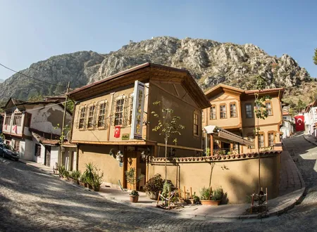
Most Amasya neighbourhoods carry the name of a hill, a fortress or a tomb; Hacılarmeydanı, one of the most populous in the central district, takes its name from a square. Known locally and on street signs as "Hacılar Meydanı" (the Pilgrims' Square), it lies west of the old core of stone bridges, rock-cut tombs and riverside mansions, on the side where the Tokat road enters the city. The flat ground now filled with apartment blocks appears in Ottoman-era records as the name of orchards, of a cemetery and of a camping ground. The neighbourhood's recent history can be read from population figures; its distant past can be pieced together from the scattered entries in Hüseyin Hüsâmeddîn Yasar's Amasya Tarihi.
Origin of the Name
Describing Amasya's orchards, Hüsâmeddîn writes that behind the gardens on both banks of the Yeşilırmak lie two great squares. The one to the north is called "Ok Meydânı" (Arrow Square), the one to the south "Hacılar Meydânı". According to him, archery was once practised on Ok Meydanı, while on Hacılar Meydanı prayers were offered for pilgrims setting out for the Hejaz and returning from it, and the two names come from these customs. The earliest and most direct record on the origin of the name thus says that the area which gave the neighbourhood its name was a square where pilgrim caravans were seen off and welcomed (Hüsameddin, Amasya Tarihi, volumes 1-4, e-book p. 103). It does not say how far back the custom goes; Hüsâmeddîn gives no date and reports it as a familiar fact of his own time.
The same work shows that pilgrimage affairs had a place of their own in the city's administration. At the beginning of 1133 AH (1720-21), when Rahtuvan Paşazâde Hacı İbrahim Bey became chief notable, a "council of pilgrims" was founded to oversee the council of notables and the great agas and to look after the affairs of those travelling to the Hejaz, and Kırmacıoğlu Hacı Hüseyin Efendi, of the mevâlî class, was chosen as head of pilgrims (e-book p. 636). The place where the council met is not stated, and tying this record directly to the square would be wrong; still, it suggests that the city had an arrangement for pilgrims and that the square may have formed part of it.
Apart from the link with the pilgrimage, there is also a family account from more recent times. The Yozgat-born writer A. Kadir Çapanoğlu, in a note added to a 2020 piece recalling his childhood and youth in Amasya, states that the large tract of land called "Hacılar Meydanı" in his childhood, later swallowed by the city, was the barley estate (arpalık) of the Çapanoğulları family in the 1800s. This does not rest on an archival document; it is a note of memory. It does not contradict the other records describing the square as a broad open tract, but the documents do not show whether the place where pilgrims' prayers were said and the place remembered as a family's barley estate were one and the same area.
Location and Place in the City
By Hüsâmeddîn's listing of the orchards, someone walking west from the Sultan Bayezid Mosque along the south bank of the river would first meet the İnehan Orchards in front of the Hacı İlyas neighbourhood, then the Yörgüç Paşa Orchards, then the Hacılar Meydanı Orchards. Further west come the Ferhâd Arası and Çalan Köprü orchards. Hacılar Meydanı thus lay in the strip where the present neighbourhood stands, at the western end of the town, and it formed a pair with Ok Meydanı on the opposite bank (e-book p. 103).
Today the neighbourhood lies within the city centre of Amasya's central district, postal code 05100. According to a 2024 petition by residents that reached the local press, it has expanded in recent decades towards Ferhat and Şirin and has come to be described as Amasya's largest neighbourhood. The same text says the new housing areas have advanced almost as far as the Dumlu petrol station. The "Ferhat and Şirin" direction in the petition falls on the same belt of orchards that Hüsâmeddîn called "Ferhâd Arası" a century ago. The narrow valley on the Yeşilırmak was shaped in stone and timber below the slopes of Harşena; Hacılar Meydanı is a wider, flatter and newer settlement area.
The Square as a Camping Ground
The square's name is not tied to pilgrims alone; in Ottoman sources it also appears as the place where senior statesmen arriving in the city pitched their tents. The road from the direction of Tokat and İnepazarı passes the Çalan Köprü and Ferhâd Arası orchards and reaches this plain, which made it a natural stopping place before entering the town. Three events recorded by Hüsâmeddîn show this.
The first concerns Murad IV's return from the Revan campaign. When it became known in Cumâdelâhire 1045 AH (1635) that the sultan had reached Tokat, festivities were prepared in Amasya, and the deputy governor Ömer Bey, the city steward Bâlî Bey, the qadi and the mufti worked to avoid the slightest mishap. The sultan did not stop at İnepazarı but set out in the late afternoon, reached Çalan Köprübaşı as the night prayer was being called, and rested in Hoca Ahmed Paşa's garden and pavilion there until eight in the evening. That night the imperial tent and the tents of the dignitaries of state were pitched on Hacılar Meydanı. Murad, however, did not go to the tents; at eight o'clock he entered the city directly and took up quarters in Hoca Ahmed Paşa's mansion on the river, opposite the Sultan Bayezid Mosque. Hüsâmeddîn writes that the preparations for the welcome procession came to nothing as a result. The next day the people of Amasya presented the sultan with a fully caparisoned horse, thirty bolts of Amasya cloth, thirty pieces of Amasya morocco leather and four purses of kuruş (e-book p. 563).
The second is an inquiry that followed disturbances in the city. Around 1143 AH (1730-31), Köprülüzâde Fâzıl Abdullah Paşa, governor of Egypt and inspector of Anatolia, came to Amasya with great ceremony, stayed in tents pitched on Hacılar Meydanı and began his investigation from there. He summoned the notables, the ulema and the sheikhs, and heard one by one the stewards of the guilds, the nakibs of the sayyids and the yiğitbaşıs of the townspeople. In the end he had Hacı İbrahim Bey, Helvacı İsmail Ağa and the principal members of their party arrested, and released many of those held earlier, since they were not among the real instigators. He sent the file of the inquiry to Istanbul (e-book p. 642).
The third belongs to Shawwal 1171 AH (1757-58). Vizier Mehmed Paşa, a former governor of Ganja sent by imperial decree to investigate grave complaints, descended on Hacılar Meydanı on reaching Amasya. He had soldiers with him, and it became clear a few days later that he was himself an Amasya man, of the house of Hindî Ahmed Paşa. He took his nephew Hacı Ahmed Bey with him and began the inquiry, but the Fazlıoğulları family, under the governor's protection, and their followers misled the pasha and persuaded him that the ulema were responsible. The former mufti Hacı Mehmed, the imaret sheikh Hacı Mehmed and the head of the Qur'an reciters, Hacı İbrahim Efendi, were taken from their homes at night and exiled to the fortress of Magosa in Cyprus; a few commoners were confined in the castle and two people were executed (e-book p. 657). Hüsâmeddîn names two causes for the pasha's mistake: the influence of his nephew and the rivalry among Amasya's notables.
The Venk Ridge and the Christian Cemeteries
One place Hüsâmeddîn mentions above Hacılar Meydanı is among the most colourful records tied to the present neighbourhood. "Venk" (or "Veng") is a ridge on the left of the Tokat highway, at the end of the Memi Dede Önü cemetery, above Hacılar Meydanı; it lies at the northern foot of the Ferhâd Rock, whose southern foot holds Helvacı Pınarı. Both sides of the ridge are cemeteries of Greek and Armenian Christians. There stand two roofed structures and a shed with an open way between them; at the end of the way, from a mass of earth shaped like a rock, water drips without cease. Under the drops is a small basin of black stone. Hüsâmeddîn writes that the water is bright but tasteless and heavy, that the surroundings are barren and that the place is held in high regard among Christians. On Sundays they gathered there and made merry, and on the way back they rubbed the barren earth on their faces and foreheads, calling it "jewel" (e-book pp. 87-88).
He also notes in the same place that this visiting is not old. Until about 1300 AH (1882-83) Greeks and Armenians were seen going there only rarely, to visit the graves, and the spot lay neglected and in ruins; after that date it became first the Armenians' and then the Greeks' Sunday meeting place. Each community ties this to a story. The Greeks say that Yovannis, a disciple of the apostle Peter, called the people of Amasya to the faith and hid there, and when thirsty commanded the stone he leaned on to flow with water; the Armenians say that the apostle Ohannis, who lived at Ejmiatsin, hid there from his enemies on his way to Kayseri. Hüsâmeddîn observes that the two accounts come from a single source, and that the name "Veng" has no connection in sound or meaning with either. He adds that Christianity appeared in Amasya only at the beginning of the fourth century AD, so the idea that two monks preached there in the first or second century is no more than a fancy (e-book p. 88).
His own proposal is that the name derives from a patriarch's name. From Greek inscriptions read on some stones of the Torumtay Mosque and Tomb and of the Halifet Gazi Madrasa and Tomb, he argues that there was once a church and patriarchate east of the place called Venk, and that the ruins prove it. After the conquest the building fell into ruin, and a madrasa, a mosque and a tomb were built from its debris. Relying on the Danishmendname, he recounts that when the patriarch of Amasya, Kirillos, died during the siege, "Vengliyus" succeeded him and stayed in this church for a long time after Melik Ahmed Danishmend Ghazi entered the city; that the Halifet Gazi Endowment Deed of 622 AH (1225), certified by the chief judge Takiyyeddin Osman bin Ali, calls the place "Vengiyas"; and that the name was shortened to "Veng" when the initial "l" dropped (e-book p. 88). This is an interpretation, and Hüsâmeddîn presents it as such, but the conclusion the sources support is plain: in Ottoman times the neighbourhood's upper slope was a meeting place held sacred by Amasya's Christian communities.
The Memi Dede Cemetery and the Halveti Circle
On the western edge of the road leading to Hacılar Meydanı, a walled garden is the tomb of Memi Dede, one of Amasya's Halveti sheikhs. Hüsâmeddîn writes that here lie Sheikh Mehmed el-Halvetî, known as "Memi Dede", his son Sheikh İbrahim Efendi, and his deputy Sheikh Hüsâmeddîn Hüseyin Efendi (e-book p. 146). Memi Dede also appears in another section listing the saints' places on the four sides of the city: Tekirdağlı Baba's on the northern gorge, Has Baba's on the southern gorge, Abdurrahman Baba's in the east and Memi Dede's in the west (e-book p. 134). He is thus remembered as the saintly presence on the city's western side.
The Hızır Paşa Lodge, to which Memi Dede belonged, was built in 971 AH (1564) by the beylerbey Hızır Paşa, of the Yörgüç Paşa line, who also arranged its endowments. Hüsâmeddîn places the lodge in the Şâmîce neighbourhood, while Kadir Özköse's article on Amasya's Halveti lodges puts it west of the Gökmedrese Mosque. Its first sheikh was İlyas Efendi, known as "Molla Şeyh". After his death Memi Dede Mehmed Efendi became sheikh, followed by his son İbrahim Efendi and then Hüsâmeddîn Efendi, and after them Mustafa Efendi, the preacher Hasan Efendi and his son Mehmed Efendi. The lodge was destroyed completely in the fire of 1143 AH (1730) and its site is unknown (e-book p. 151). The sources differ slightly on whose name it was: the main text of Hüsâmeddîn and of Özköse distinguishes Memi Dede as Mehmed Efendi and his son as İbrahim Efendi, whereas Özköse's footnote names İbrahim Efendi as "Memi Dede". In a list of sheikhs from later periods, "Memi Dedezâde İbrâhim Efendi" appears as sheikh of the Hızır Paşa Lodge, so the name had become a family name.
The site of the tomb has since changed. Özköse writes that the tomb in the Memi Dede Cemetery in the Hacılar Meydanı neighbourhood was demolished and lost when a road was cut beside it, and that today a marble grave in his name lies beneath the Tokat road. The cemetery on the western side of the city also bears the sheikh's name. The neighbourhood's name and the cemetery's name are tied to the same road: it is the route leading to the square and to Memi Dede alike.
The Ferhad Water Channel and the Surroundings
The "Ferhâd Arası" orchards west of the square lie close to Amasya's well-known great water channel. Hüsâmeddîn writes that the channel begins at Şâhîn Kayası, passes through Ferhâd Arası and in front of Memi Dede, circles the Gökmedrese, Şâmîce, Receb, Çeribaşı, Acem Ali, Uzun Mustafa, Gümüşlüzâde, Mehmed Paşa and Sevadiye neighbourhoods, and ends in a hole in a rock south of the Kibrithane in the Bayezid neighbourhood. Its length is about eighteen kilometres; it is cut as a tunnel through the rock in four or five places, and deposits of lime ten centimetres thick are seen inside. Popular belief ascribes the work to Ferhad, the lover of Şirin, and Kara Müftüzâde Mustafa Vâzıh Efendi repeats this view. Hüsâmeddîn objects that a single man could not have finished such a work in thirty-nine years, let alone thirty-nine days, and holds that a powerful state built it two thousand years ago. He also reports two other accounts of the name Ferhad, one from the Danishmendid commander Ferhad Ghazi and one from a Sasanian governor, Ferhad bin Efruhte, and he leans towards the first (e-book pp. 86-87).
The spring called Helvacı Pınarı at the southern foot of the same rock was named for the fountain built by Helvacı Mehmed Ağa, a former deputy governor of Amasya who died in 1064 AH. The Amasya notable el-Hâc İbrahim Ağa restored the spring in 1210, cleaned its channel, set the water flowing again and endowed a few shops. Between that spring and Ferhâd Arası stood a second fountain called "Bey Pınarı", built in 1164 by el-Hâc Osman Bey, a former mirliva of Egypt. When Hüsâmeddîn wrote, both were in ruins (e-book p. 87). These fountains show that the surroundings of the square lay both on the city's drinking-water line and on the Tokat road.
Known Buildings in the Neighbourhood
Today's Hacılarmeydanı is not a neighbourhood known for monumental buildings. Even so, a few structures shape its identity.
- H. Hasan Çapkınoğlu Mosque: According to local guide information it stands on Orhun Sokak, within the neighbourhood. No sourced information on its date of construction could be found.
- Hattat Hamdullah Efendi Mosque: It is shown on Sadık Ahmet Caddesi, within the neighbourhood's boundaries. It takes its name from the great calligrapher Sheikh Hamdullah, who lived between 1436 and 1520 and is closely identified with Amasya. Its construction date could not be verified; no historical tie is claimed beyond the name's link with the calligrapher.
- Schools: The Hattat Hamdullah Imam Hatip Middle School gives its address as Çapkınoğlu Sokağı, Hacılar Meydanı. According to the residents' petition, the Yavuz Selim and Serdar Zeren middle schools are also in the area.
- Memi Dede Cemetery and tomb site: This area beside the Tokat road carries the neighbourhood's oldest monumental memory.
The same petition states that in the last twenty years the number of mosques in the neighbourhood has risen from one to six, while the number of schools has stayed at two for about twenty-five years, with class sizes sometimes reaching 40 to 60. The petitioner also alleges that some green areas and plots set aside for schools were converted to places of worship by municipal council decisions. These figures and claims are the residents' own statements; they should be read not as official statistics but as an indication of the felt burden of rapid growth.
Not to Be Confused with Nearby Monuments
Some of Amasya's better-known monuments may be linked with Hacılarmeydanı because of similar names, yet they belong to other neighbourhoods. The Station (Meydan) Bridge joins the İstasyon and Hacı İlyas neighbourhoods. It is known that the first bridge was built in 1145 by the Seljuk sultan Mesud I, that it was destroyed by earthquakes and floods, and that the present bridge was built on the remains of the first in the 1370s by the then emir of Amasya, Şadgeldi Paşa. The bridge was badly damaged in the flood of 1824, repaired in 1828, and had its deck widened and concreted in 1940. It takes its name from standing in front of the great gate of Amasya Castle called the Meydan Gate. The "Meydân Köprü" mentioned by Hüsâmeddîn is the bridge from whose northern bank Ok Meydanı begins, and no link with Hacılar Meydanı has been established; the two "squares" should not be confused. The rock-cut tombs, Harşena Castle and the riverside mansions are likewise the heritage of the neighbouring historic core, not of this neighbourhood.
Population and Change
The neighbourhood's recent story is written in its population figures. According to a series compiled from TÜİK/ADNKS data, the population has changed as follows:
- 2012: 10,097
- 2013: 10,908
- 2014: 12,003
- 2015: 12,863
- 2016: 13,474
- 2017: 14,324
- 2018: 14,390
- 2019: 14,837
A similar compilation gives 14,988 for 2023 and 15,426 for 2024 (7,540 men, 7,886 women). These last two figures have not been verified independently against the TÜİK tables. Taken as a whole, the series shows an increase of about forty-seven percent in seven years, nearly half again; after 2018 growth slowed and the neighbourhood settled at around fifteen thousand people. Such an increase turns into places in classrooms, rows in mosques, market stalls and roadside parking, and the complaints quoted above are the result of this pressure.
Hacılarmeydanı Today
Today Hacılarmeydanı is one of the places where daily life in Amasya is at its busiest. The neighbourhood headman's office, schools, mosques, apartment blocks and local shopkeepers set the frame of that life. A local news headline saying that Amasya Municipality brought a café to Hacılar Meydanı also shows the area being used as a public meeting place; since the details of the report could not be reached, nothing more is written.
The neighbourhood still has open questions. The date at which the name was first used, whether the Çapanoğulları barley estate and the pilgrims' square were the same area, what became of the building remains on the Venk ridge, and when the neighbourhood was established as an administrative unit have not yet been written from documents. Islamic court registers, land survey registers and municipal archives may shed light on some of them.
Chronology
622 (1225): The Halifet Gazi Endowment Deed refers to the Venk ridge as "Vengiyas" (Hüsameddin, Amasya Tarihi).
971 (1564): The beylerbey Hızır Paşa builds the Hızır Paşa Lodge, where Memi Dede later served as sheikh (Hüsameddin; Özköse).
1045 (1635): Murad IV's imperial tent and the tents of the dignitaries of state are pitched on Hacılar Meydanı, while the sultan enters the city directly (Hüsameddin).
1133 (1720-21): A council of pilgrims is founded in Amasya to look after those going to the Hejaz; the head of pilgrims is Kırmacıoğlu Hacı Hüseyin Efendi (Hüsameddin).
1143 (1730-31): Köprülüzâde Fâzıl Abdullah Paşa pitches tents on Hacılar Meydanı and investigates the disturbances in Amasya; the Hızır Paşa Lodge is destroyed by fire (Hüsameddin; Özköse).
1171 (1757-58): Vizier Mehmed Paşa descends on Hacılar Meydanı for an inquiry; three men of the ulema are exiled to Magosa (Hüsameddin).
c. 1300 (1882-83): The Venk ridge becomes a Sunday gathering place first for Armenians, then for Greeks (Hüsameddin).
1800s: The broad area called Hacılar Meydanı is, according to a family account, the barley estate of the Çapanoğulları (A. Kadir Çapanoğlu, 2020).
2012-2019: The neighbourhood's population rises from 10,097 to 14,837 (TÜİK/ADNKS compilation).
2024: Residents say through the local press that the number of schools does not keep pace with the growing population.
Bibliography
Primary sources
- Hüseyin Hüsâmeddîn Yasar, Amasya Tarihi, volumes 1-4 (Amasya Municipality, 2022), section on orchards and squares, e-book p. 103.
- Hüsâmeddîn, Amasya Tarihi, volumes 1-4, Ferhâd Rock, Helvacı Pınarı and Venk, e-book pp. 86-88.
- Hüsâmeddîn, Amasya Tarihi, volumes 1-4, Murad IV's arrival in Amasya, e-book p. 563.
- Hüsâmeddîn, Amasya Tarihi, volumes 1-4, Fâzıl Abdullah Paşa's inquiry, e-book p. 642; Mehmed Paşa's inquiry p. 657; council of pilgrims p. 636; Memi Dede Tomb p. 146; saints' places on the four sides p. 134; Hızır Paşa Lodge p. 151.
- A. Kadir Çapanoğlu, "Şehr-i Amasya'da Halkalı Evliya ve Çakallar Tepesi", Yozgat Gazetesi, 11.07.2020.
Official sources
- Republic of Türkiye Ministry of National Education, website of Hattat Hamdullah Imam Hatip Middle School.
- Ministry of Culture and Tourism, Culture Portal, "İstasyon Köprüsü" (Amasya).
Other sources
- Kadir Özköse, "Amasya'da Bulunan Halvetiyye Tekkeleri", Akademiar, no. 5 (December 2018), pp. 91-118.
- "Amasya Hacılar Meydanı Mahalle Sakinlerinin Yetkililerden Bir İsteği Var", 05.com.tr Amasya Haber, 29.05.2024.
- nufusu.com, "Merkez Mahalleleri Nüfusu Amasya" (TÜİK/ADNKS compilation, 2012-2019).
- nufusune.com, "Hacılar Meydanı Mahallesi Nüfusu, Merkez Amasya" (2023-2024 values). amasya.bel.tr
Online sources
- https://amasya.bel.tr/uploads/e-kitap/kitap/1-4/files/basic-html/page87.html
- https://amasya.bel.tr/uploads/e-kitap/kitap/1-4/files/basic-html/page563.html
- https://amasya.bel.tr/uploads/e-kitap/kitap/1-4/files/basic-html/page642.html
- https://dergipark.org.tr/tr/download/article-file/606666
- https://www.yozgatgazetesi.com/a-kadir-capanoglu/sehr-i-amasya-da-halkali-evliya-ve-cakallar-tepesi-139110.html