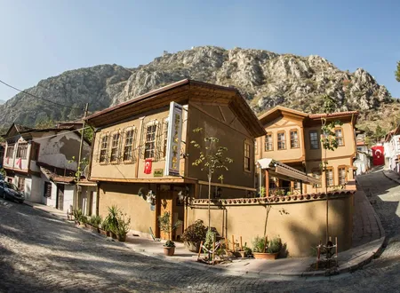
Karasenir Neighbourhood, part of the central district of Amasya, is one of the city's small neighbourhoods today. It lies to the south-west of the city centre, spread around a hill on the west bank of the Yeşilırmak. Its name is most often linked with the tomb on that hill, that of the shepherd saint Serçoban. Yet the past of the neighbourhood is not confined to that legend. In Hüseyin Hüsâmeddîn Yasar's Amasya Tarihi its name appears in records that reach back to an emir's farm, to the endowment of a Danishmendid ghazi, and to the birthplace of a commander of the Hejaz. Nineteenth-century censuses give its number of households, and documents on recent repairs trace what has happened to the tomb. The part resting on documents and the part resting on local tradition are kept apart below.
From Village to Neighbourhood
In writings on Amasya, Karasenir is mentioned as a village that in time became a neighbourhood of the city. Surveying the city of his own day quarter by quarter, Yasar states that there were fifty-three neighbourhoods within the city limits, and then adds: "outside the city there are two more neighbourhoods, which are also counted as belonging to Amasya." The first of these is Karasenir, the second Kayabaşı to its south. Yasar places Karasenir to the south-west of Amasya, about eleven kilometres from the city. The neighbourhood is thus counted not as a district attached to the centre but as a settlement lying apart from it.
No definite date can be given for the completion of this transition. Recent documents also show that the neighbourhood was run like a village for a long time. The registration form for the tomb records that in 1980 a partial repair was carried out by the "headman's office of Karasenir Village." Bekir Başalan, who studied the settlements of Amasya whose names were changed, also lists Karasenir among the villages later turned into neighbourhoods, together with Boğazköy, Fındıklı, Helvacı, Orman Bağları, Saraycık, Yazı Bağları, Yeniköy and Yeşilyenice. The change from village to neighbourhood belongs to a general movement that many settlements in the central district went through; the year of attachment is not stated in the documents.
Origin of the Name
The oldest and clearest information on the origin of the name comes from Yasar. According to him, the place was called "Kara Sungur Farm" because it was the farm of Emir Seyfeddin Kara Sungur, and over time this name was worn down in speech until it became "Karasenir." Yasar attributes the change to the mispronunciation of a sound read with the nasal kef and an open sin, and describes it as a "tahfîfen galat," that is, an error produced by abbreviation. The name of Kayabaşı to the south is explained in the same way: it was the farm of Emir Kayabay and so was recorded as "Kayabay Farm," later becoming "Kayabaşı." That two neighbouring names arose in the same manner, from an emir's ownership of a farm, makes the explanation convincing.
The identity of Kara Sungur is a separate matter of debate. Elsewhere in his book Yasar speaks of the Sungur family of Amasya. According to this information, the descendants of Seyfeddin Sungur, one of the emirs who died in the early 700s of the Hijri calendar, are called the "Sungur lineage," and the line later divided into three branches: the Osman Paşazades, the Çeribaşızades and the Yahşi Beyzades. Yasar also places the Bozahane Quarter on the site of the "property of Emir Seyfüddin Sungur" and the Çeribaşı Quarter on the former "Sungur property." Whether the "Kara Sungur" who owned the farm at Karasenir belonged to this family Yasar does not say outright. The similarity of the names and titles suggests such a link, but no document confirming it has been found in this survey.
Karasenir in the Older Records
According to Yasar, the neighbourhood had a mosque and a school built by Kara Sungur Bey; in the author's own day both were kept going by the donations of the inhabitants. The same passage reports that the commander of the Hejaz, Mirliva Hasan Pasha, came from this neighbourhood. The fact that the man who had the Serçoban Tomb built in 1878-1879 is called "Hasan Pasha of Karasenir" therefore ceases to be a later addition by local tradition and rests on an entry in Yasar's text. No other information has been found on the pasha's year of birth, the dates of his ranks or the details of his service.
Karasenir's tie to an older endowment is also found in Yasar's book. In the section introducing the İltekin vineyards on the western slope of Amasya, he speaks of the tomb of İltekin Gazi, said to have been one of the Danishmendid emirs and of the Khwarazmian Turkmens. According to Yasar, "Yazı Bağları and the Karasenir Quarter as a whole" were this ghazi's endowment, and until 1160 (1747) the ghazi's descendants held them as trustees. The same passage reports that around the tomb there stood, in records of 1052 (1642), a new town once called "Simre," with its mosque, two small mosques and a school; Yasar says that in his own time this quarter no longer existed and that its endowment revenues had passed to the treasury. It follows that until the middle of the eighteenth century Karasenir was part of the city's old endowment system. The same source does not explain which part of Karasenir the endowment covered, what its income was or who ran it.
In the later volumes, where Yasar lists notables and deputy governors, the name Karasenir appears for the end of the seventeenth century together with the word "malikâne," a life-tenure revenue grant. A record in volumes 9-12 reports that the son of an Ahmed Çelebi died around 1097 (1685-86) while holding the "Karasenir Malikâne." The text is tangled with the names of notables and trustees, so it has not been possible to establish who the man was, how much land the grant covered or how it related to the Kara Sungur farm. Even so, the line shows that in the seventeenth century Karasenir was an income-producing holding entered in the records.
Geography and Neighbours
The position of the neighbourhood is best understood between the Yeşilırmak and the Çekerek River. Yasar writes that the Çekerek comes from the direction of Zile, skirts the west side of the Kayabaşı Quarter in the south-west of Amasya and joins the Yeşilırmak "in front of Serçoban Hill." Serçoban Hill is thus named as a landmark where the two rivers meet. The registration form likewise places the tomb on a hill on the west bank of the Yeşilırmak. According to Yasar, the old name of the Çekerek is "Askilakis"; the small size of the river, its swelling in spring and its occasional drying up have led him to think that the name may be a corruption of the Turkish word "Sengilik." This interpretation is Yasar's own and cannot be regarded as proven.
Kayabaşı, to the south of Karasenir, is described by Yasar as a triangular island of land between the Yeşilırmak and the Çekerek. He writes that it was the farm of Emir Kayabay, and that a pleasant spot on the river bank is called "Pehlivan" because Kayabay's son, Emir Şücaeddin Pehlivan Bey, lived there. In Yasar's account Karasenir and Kayabaşı appear as two neighbouring farm settlements.
Karasenir in the Nineteenth-Century Censuses
In his article comparing the population register of 1840 (H. 1256) with the tax-income registers of 1844-1845 (H. 1260-1261) for Amasya, Selim Özcan gives the household numbers of the quarters in a table. In it Karasenir appears with 61 Muslim households in the population register and 48 households in the tax-income survey; there are no non-Muslim households. In the same surveys its neighbour Kayabaşı has 76 and 68 households respectively. According to Özcan, the difference between the two surveys arises partly from their different procedures: the population count rests on copies drawn up at the centre, the tax-income survey on original records taken on the spot. Whether the fall from 61 to 48 reflects real migration therefore cannot be said with certainty.
The surveys nonetheless show the scale of the neighbourhood. In the same table the Beyazıd Paşa Quarter stands among the first with 112 Muslim and 104 non-Muslim households, while Karasenir remains a small settlement beside the large districts of the city. That Karasenir and Kayabaşı are listed alongside the city's quarters shows that in the nineteenth century too they were included in the administrative census of the city.
Serçoban and Karasenir
The person most often named together with the neighbourhood is Serçoban. Because "ser" means head, the name means head of the shepherds. According to local sources Serçoban's real name was İbrahim; he came from Tabriz and completed his studies there under Sheikh Taceddin Ebu Hamid Abdurrahman et-Tebrizi. According to one account this teacher was a descendant of Imam Husayn. At the end of his journey İbrahim settled in Amasya, taught there and was held in esteem by the people and by the officials of the state. Amasya's mayor Mehmet Sarı repeats the same information in his speech at the 2020 opening: he says that his real name was İbrahim and that he came to Amasya from the Iranian city of Tabriz.
From this point the account takes a turn. İbrahim, who fled the tyranny of Kongortay, the Mongol governor in Anatolia, or fell out of his favour, withdrew from the city, retreated to the neighbourhood of Karasenir Village and began to earn his living as a shepherd. According to one of the versions transmitted, he regained his former standing in the time of Ghazan Khan. Since Ghazan Khan reigned between 1295 and 1304, the account places Serçoban in the age of Ilkhanid rule at the end of the thirteenth and beginning of the fourteenth century. The sources, however, give no definite information about his birth and death years. One local record says he lived about 150 years before his supposed brother İğneci Baba; this statement is not supported by any other document. That the period in which the village was the Kara Sungur farm and the period in which Serçoban is thought to have lived fall close together is not, on its own, proof of a connection.
İğneci Baba, who is named as Serçoban's brother, is a saint who worked as a cobbler, and his tomb is said to be in the Kocacık Bazaar in the centre of Amasya. Some local writings also mention the closeness of the two brothers to Sheikh Safiyüddin Mahmut; Serçoban is presented as a brother known for the simplicity of his manner and for earning his living as a shepherd. No historical basis has been given for this fraternal bond. In the tale one brother lives in the bazaar and the other on a mountain top; one is a tradesman, the other a shepherd.
The Serçoban Tomb
The Serçoban Tomb stands within the boundaries of Karasenir Neighbourhood, on the hill on the west bank of the Yeşilırmak. According to the registration form, the building is single-storey, rectangular in plan and has a pyramidal roof; it is covered with Marseille-type tiles and has two rectangular windows in each side wall. Since the building is used as a small mosque, it contains a mihrab and a wooden minbar. At the foot of the north wall lies a rectangular grave of concrete, with turbans at its head and foot. The form lists simple hearths for cooking, wooden dining tables and trees in its garden, and states separately that there is no inscription and no endowment deed.
The first known date of construction is 1878-1879, when Mirliva Hasan Pasha of Karasenir, commander of the Hejaz, had it built. The sources say that this first building was of wood. In his speech of 2020, Mayor Sarı says that until 2001 the tomb remained a masonry structure "like the old Amasya houses" and that in 2001 it was converted into reinforced concrete. The two pieces of information do not fully agree: when the wooden building became masonry, or even whether the two statements describe the same building, cannot be understood from the documents. The repair notes in the registration form are more detailed. According to them, in 1980 the headman's office of Karasenir Village had a partial repair made, in 1984 a private person carried out a thorough repair, and the landscaping was undertaken by Amasya Municipality.
According to Sarı, the tomb was neglected after 2001 and its surroundings were left abandoned. The municipality then carried out restoration at the tomb and landscaping around it; the project, named "A Shepherd in the Seven Worlds, Sultan of Hearts, Serçoban," was opened, according to a news item of 13 October 2020, in a ceremony with wide attendance. The then governor of Amasya, Mustafa Masatlı, as well as members of parliament and party representatives, were present. In his speech Sarı said that Amasya has more than twenty tombs of holy men, that Serçoban is counted among them; he referred to the visitors' practices of lighting candles, vowing sacrifices and circling the tomb, and remarked that these are a matter of belief, but that tombs should not be treated as places of worship and that wishes should be asked of God.
The area opened at about 11,000 square metres. Because of the heavy interest it drew, the municipality began work on an additional picnic area four months after the opening, in February 2021; Sarı inspected the work on site and prayed at the tomb. Thus in 2020 the tomb was not only repaired but turned, together with its surroundings, into an area the people of the city use for day outings.
Customs of Visiting
The tomb is visited especially for blessing prayers, and people come for every kind of illness and wish. On Fridays those who come pray and recite the Qur'an; on other days visitors circle the tomb seven times, offer candles and kiss the tomb at various places. The wishes of women without children are made together with the keeper of the tomb. Most vows are vows of sacrifice, and places for slaughtering sacrifices and cooking food have been arranged around the tomb. These practices are familiar forms of Anatolian shrine culture.
Stories About Serçoban
In the memory of the neighbourhood history and legend are intertwined, and the two have to be separated. The best-known legend concerns the trees. According to local tradition, when Serçoban died every animal of his flock turned into a tree, and so a forest grew around the grave. Because of this belief the people of the region think that cutting the trees around the grave would bring them misfortune. A poet and mystic from Amasya has said that as a child he was taken to visit the tomb, that this broad place was famous for its trees, and that the story that cutting a tree brings trouble was passed on from mouth to mouth.
The second legend concerns a kid. While grazing his flock on the mountain, Serçoban chases a kid that has run away; the kid flees, the shepherd grows very tired and says, "When I catch you I will slaughter you." He finally catches it and is about to keep his word when he meets the animal's sad and moving gaze. Moved, he says, "You have tired me out too, blessed one," and lets the kid go. In another version of the same legend the captured animal is kissed on the eyes, Serçoban takes it to a secluded place to slaughter it, a herd of wild animals surrounds him and tells him to slaughter, and Serçoban picks a roe deer from among them and slaughters that. The same plot is found in the legend of Koyun Baba in the Osmancık district of Çorum. There it is told that Baba tended sheep on the slopes of Adatepe, chased a runaway sheep nine times round the hill, that both grew tired and that in the end he embraced the sheep and kissed it on the eyes. Because the legends attached to shepherd saints in Anatolia carry similar patterns, it is possible that the Serçoban tale drew on an older narrative tradition of the region.
The third story concerns his brother İğneci Baba and shows Serçoban in a test of miraculous power. One day Serçoban visits his elder brother, who works as a cobbler; he has brought as a gift milk drawn from his sheep, tied up in a handkerchief, and his aim is to show that the milk does not seep through the cloth. He hangs the handkerchief on a nail in the wall of the shop. At that moment İğneci Baba is taking the foot measurement of a woman customer. As Serçoban sees the woman's heels and thinks to himself "how beautiful they are," milk slowly begins to drip from the handkerchief hanging on the nail. İğneci Baba senses the impurity in his brother's intention but shows nothing. When the woman has given her measurement and left the shop, he says to his brother: "The miracle is not in reaching sainthood on a mountain top; the miracle is here, in not letting the milk in the bundle drip." The same legend is reported to be told of Piri Baba, who lies in Merzifon, and his brother Çoban Baba.
Other accounts mention legends that show Serçoban's generosity and scrupulousness. When his sheep strayed into someone else's garden he would not drink the milk of that sheep for three days and gave the milk to the villagers free of charge. It is also told that he fed a commander passing through the region and his thousands of soldiers with a little food. These legends are not counted as historical fact; they are valuable as the stories the neighbourhood tells about itself.
Buildings in the Neighbourhood
The oldest religious building of the neighbourhood to appear in records is the mosque and school of Kara Sungur Bey mentioned by Yasar. No information has been found on the present state of these buildings, nor is it clear which mosque of the period after Yasar's day they could be identified with. In today's lists of the mosques of Amasya, three mosques appear within the boundaries of Karasenir Neighbourhood under the names Karasenir Mahallesi Mosque, Ağıllar Mosque and Serçoban Mosque; the Serçoban Mosque is reported to stand on Serçoban Street. No documents on the construction dates and histories of these mosques have been found. The name of the Ağıllar Mosque ("Sheepfolds") recalls the neighbourhood's past ties to stock-raising, but this is an inference and does not rest on a document.
Population and Change
The neighbourhood is small and has been shrinking for years. According to TÜİK's address-based population registration system (ADNKS), its population was 788 in 2012 and 789 in 2014, and generally declined in the following years. At the end of 2025 the population is 665, of whom 331 are men and 334 women. The sex distribution is almost equal (49.77 per cent men, 50.23 per cent women). The total population by year is as follows:
- 2012: 788
- 2013: 772
- 2014: 789
- 2015: 776
- 2016: 739
- 2017: 749
- 2018: 741
- 2019: 722
- 2020: 719
- 2021: 696
- 2022: 685
- 2023: 678
- 2024: 675
- 2025: 665
The fall from the highest value in the series, 789, to 665 points to a decline of 124 people in eleven years. From 2018 to 2025 the drop is seventy-six. This slow emptying, seen in many neighbourhoods on the edge of cities, may be explained by young people moving to the city centre or to other provinces; but no separate study exists for Karasenir, so no comment is made on the cause.
Karasenir Today
Today Karasenir is known to Amasya mainly for the Serçoban Picnic Area. Those who want to visit the tomb and those who want to get away from the city for a short while meet on the same hill; the area becomes crowded especially at weekends and in the spring months. The area was laid out by Amasya Municipality. The tomb's closeness to the provincial centre keeps the number of visitors high in proportion to the neighbourhood's population; while the number of residents shrinks, the appeal of the hill has continued.
Chronology
Only dates documented in the sources:
1052 (1642): The Simre quarter around the tomb of İltekin Gazi appears in records of this date.
Around 1097 (1685-86): The son of an Ahmed Çelebi is recorded as dying while holding the Karasenir Malikâne.
1160 (1747): Until this date the endowment of İltekin Gazi, which included Karasenir, is held by the ghazi's descendants.
1840: In the population register Karasenir is entered as 61 Muslim households.
1844-1845: In the tax-income registers Karasenir appears with 48 households.
1878-1879: The Serçoban Tomb is built of wood by Hasan Pasha of Karasenir.
1980: The headman's office of Karasenir Village carries out a partial repair at the tomb.
1984: The tomb is thoroughly repaired by a private person.
2001: The tomb is rebuilt in reinforced concrete.
2012: The neighbourhood's population is recorded as 788 (ADNKS).
13 October 2020: The Serçoban Tomb and picnic area, with restoration and landscaping completed, are opened.
February 2021: Additional work begins to enlarge the picnic area.
2025: The neighbourhood's population is recorded as 665 (ADNKS).
Bibliography
Primary sources
- Hüseyin Hüsâmeddîn Yasar, Amasya Tarihi, Amasya Municipality, 2022, volumes 1-4 (Karasenir and Kayabaşı quarters, p. 176; Çekerek River, p. 95; endowment of İltekin Gazi, pp. 86-87; Sungur lineage, pp. 322-323) and volumes 9-12 (Karasenir Malikâne).
- Selim Özcan, "H.1256 (1840) Tarihli Amasya Nüfus Defteri ile H.1260-1261 (1844-1845) Tarihli Amasya Temettuat Defterlerinin Karşılaştırmalı Değerlendirilmesi", Studies of the Ottoman Domain, vol. 6, no. 11, 2016.
- "Amasya Serçoban Evliyası", Gündem Amasya, 2018.
Academic studies
Official sources
Other sources
- "Serçoban Türbesi'nin Açılış Töreni Gerçekleştirildi", 05.com.tr, 13 October 2020.
- "Başkan Sarı, Serçoban mesire alanındaki genişletme çalışmasını inceledi", İHA, 20 February 2021.
- "Serçoban", Amasya Provincial Directorate of Culture and Tourism.
- "Serçoban", Amasya blog (amasya-abdulhalim.blogspot.com), 2007.
- "Karasenir Mahallesi Nüfusu (Merkez, Amasya)", nufusune.com (TÜİK ADNKS data, 2012-2025).
Online sources
- https://amasya.bel.tr/uploads/e-kitap/kitap/1-4/files/basic-html/page134.html
- https://dergipark.org.tr/tr/download/article-file/268330
- https://www.kulturportali.gov.tr/turkiye/amasya/kulturenvanteri/ser-coban-turbesi
- https://www.05.com.tr/haber/2876/sercoban-turbesinin-acilis-toreni-gerceklestirildi.html
- https://amasya.ktb.gov.tr/TR-59492/sercoban.html
- https://www.nufusune.com/1309-amasya-merkez-karasenir-mahallesi-nufusu