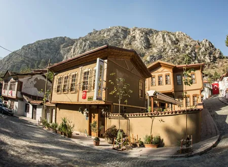
Amasya's historic core is squeezed between the two banks of the Yeşilırmak and the slopes of Mount Harşena. Pontic royal tombs, Ottoman complexes and riverside mansions stand side by side along this narrow strip. Kirazlıdere lies outside that core, in the part of the city where its service and transport needs are concentrated, and it is a neighborhood of the central district. The state hospital, the intercity bus terminal, several public directorates and Kirazlı Dere Avenue shape its daily life today. Even so, the name is no recent invention. In the Amasya Tarihi that Hüseyin Hüsâmeddîn Yasar wrote in the early twentieth century, "Kirazlıdere Orchards" appear among Amasya's known pleasure-garden and orchard districts, and a rescue excavation in 2014 uncovered an Early Byzantine cemetery beneath the soil of the same area. The neighborhood's past has to be read together with the gaps that lie between these two records.
Origin of the Name and the Kirazlıdere Orchards
The name consists of two words: kiraz (cherry) and dere (stream). In Turkish the suffix "-lı" marks a place as full of something, so the name evokes a stream, or a stream bank, associated with cherry trees. One of the neighborhood's main arteries still bears the name "Kirazlı Dere Caddesi".
The earliest documented trace of the name is in Hüsâmeddîn Yasar's book. Listing Amasya's orchards along the Yeşilırmak, the author mentions a strip on the river's south bank running east from the Bayezid Pasha Mosque, beginning at Âhûr Önü and reaching the Ayavasıl orchards and the line of Ziyâre Quarter, and says: "the southern parts of Ayavasıl are generally known as the Kirazlıdere Orchards." On the same pages the "Ziyâre", "Kirazlıdere" and "Derbend" orchards are counted among the well-known stops of the outing season that begins in spring and lasts until the end of May. The Amasya the author describes is one in which orchards stretch along both banks of the river in a band roughly eighteen hours long and are named after their locations and owners. Kirazlıdere is one link in this naming tradition and appears as the name of an orchard district, not of a settlement.
This record shows that the name was established long before it was used for a neighborhood. By contrast, no documented explanation could be found of which stream, which cherry orchards or which date the name goes back to. Because Turkey has many villages, neighborhoods and watercourses called "Kirazlı" or "Kirazlıdere", some of the origin stories circulating on the internet were written for settlements in other cities and should not be attributed to Kirazlıdere in Amasya. The study compiling the settlements in Amasya province whose names have been changed does not list this name as a village either, and there is no document showing that the neighborhood was a village before gaining neighborhood status. It appears that Kirazlıdere, an urban fringe named after its orchards, became one of the city's newer neighborhoods in the second half of the twentieth century.
Byzantine Traces and the Tale of the King's Palace
Hüsâmeddîn records that on the road to the Kirazlıdere orchards, at the Âhûr Önü boundary, a rectangular domed structure and other ancient remains came to light inside a field. According to him this area was once known as the "Kral Sarayı" (King's Palace), and in some sharia-court documents the whole district was called "Foka". The author argues that the palace of the Byzantine emperor Phocas and the quarter of his children were here. In the second volume the subject is taken up again: the King's Palace that surfaced in the Foka (Bayezid Pasha) Quarter, "in the field on the road to Kirazlı Dere, in front of today's Kibrithane", is taken as proof that Phocas was a native of Amasya.
This account should not be read as established fact. Hüsâmeddîn's own wording is "it is supposed", and the claim that Phocas was born in Amasya has not been supported by other sources. Two aspects of the record, however, are solid: in the early twentieth century a domed structure came out of the ground around this orchard road, and local memory calls the place by a separate name, "Kral Sarayı" and "Foka". The author also notes that quarters named Fokas, Helkis, Komnus, Vengiyus and Mağdinus were known in Byzantine Amasya, and that only some of them could be located. The Bayezid Pasha Quarter was later founded on the site of the Foka Quarter and is the nearest settled quarter to the Kirazlıdere road.
The Early Byzantine Necropolis
The Byzantine trace in this area is not limited to written tradition. The Amasya Museum Directorate carried out a necropolis rescue excavation in 2014 on a plot in Kirazlıdere Neighborhood. İ. Polat presented the excavation in a 2015 paper, and Banu Uz and Fadime Suata Alpaslan studied the finds in 2018 in an article titled Kirazlıdere (Amasya) Erken Bizans Dönemi Nekropolü (The Early Byzantine Necropolis of Kirazlıdere, Amasya). According to the study, the site consists of 22 rectangular graves dated to AD 330-726 and covered with flat capstones. The researchers write that these graves belong to the first Christians who lived under the Eastern Roman (Byzantine) rule that governed Amasya from the fifth century onward. The article describes Kirazlıdere as one of the oldest settlement areas founded north of the city center.
The skeletons from the same excavation are the subject of a separate study published by the same authors in 2017 in the Cumhuriyet University Faculty of Arts and Sciences Journal of Social Sciences. It examines the jaws and teeth of 32 individuals, 9 men, 7 women, 2 children and 14 of undetermined sex, and looks at the distribution of caries, wear, abscesses, antemortem tooth loss, hypoplasia, alveolar loss and calculus across 156 teeth. The skeletons are reported to have been taken to the Amasya Museum. In rescue excavations run by the same directorate, Roman and Byzantine graves have also been found in the Şamlar, İhsaniye, Kurşunlu and Dere neighborhoods; the Kirazlıdere necropolis is one link in this series that maps the burial grounds outside ancient Amaseia.
No document directly connects the "King's Palace" remains described by Hüsâmeddîn with this necropolis. That both lie in the area known as Kirazlıdere shows that the land here was used by the city long before the twentieth century. There is also a snag about location: Hüsâmeddîn places the Kirazlıdere orchards on the river's south bank, east of the Bayezid Pasha Mosque, while the modern article places the necropolis north of the city center. How far the old orchard name covers the present neighborhood boundaries is not documented.
The Bayezid Pasha Area in the Ottoman Period
Ottoman endowment buildings stand at the head of the road that opens onto the old orchard belt west of the neighborhood. According to Hüsâmeddîn, the Bayezid Pasha Quarter lies south of Kuş Köprü on the site of the old Foka Quarter; it is bounded by orchards on the east, a stream on the west, the Savakça Quarter on the south and the Yeşilırmak on the north. It was named after Bayezid Pasha, son of Yahşi Bey, who lived here until 816 AH (1413-14). The pasha built a mosque on the riverbank, a guesthouse and a soup kitchen to its east, completed them in 817 (1414-15) and drew up the foundation deed in 820. The Arabic inscription on the mosque's door states that construction took place in Muharram 817. The author reports that the mosque's master builder was Şemseddin Ahmed-i Şâmî, who carved his name on the left side of the door; the building faces the river and is known for its marble facade and carved door.
The same page carries another record tied directly to this road. In the area of the road leading to Kirazlıdere, on the qibla side of the Bayezid Pasha Mosque, an emir called "Gâzi Bey" had a mosque built in 937 (1530-31), with a fountain in front of it and a school building adjoining it, and endowed his properties to it. The author does not say what became of the mosque later. Even so, the record shows that the Kirazlıdere road was more than an orchard track: at the start of the sixteenth century there was a mosque, a fountain and a school along it, and the road was a link running from the city's settled quarters to the orchard district.
The story of the Kocacık Bath east of the mosque belongs to the same surroundings. Ayas Ağa, the Küçük Kapı Ağası, had the bath built in 900 AH (1494-95) on a plot bought from Kocacık Hoca Ahmed Çelebizâde Hoca Mehmed Çelebi, and in the same year endowed the eight houses he had built east of the bath, the mill in front of the gate of the Bayezid Pasha complex and the garden beside it. The revenue was assigned to the mosque, madrasa and school in the Şamlar Quarter. The author writes that the name came from the plot owner's name and was later wrongly pronounced "Kumacık". These buildings, which lie outside Kirazlıdere's boundaries, show whose endowments shaped the road leading to the neighborhood and the orchard district.
Location and Surroundings
Kirazlıdere is a neighborhood of Amasya's central district. According to address and map records, its boundaries include Kirazlı Dere and Mehmet Varinli avenues and streets such as Armutlu, Aydoğan, Bor, Cihan Hatun, Emir Gazi, Hacı Bektaş, Karatay, Sinan Paşa, Şifa, Talaş, Tarım, Teknik and Veteriner. Address directories list Kirazlıdere Mosque and the Sanayi Mosque on Mehmet Varinli Avenue as the neighborhood's mosques, and the State Hydraulic Works, the Highways Directorate, the Directorate of Public Works and Settlement and the Plant Protection Branch Directorate as its public institutions. This list comes from address directories and is not an official document on the neighborhood's boundaries.
Two institutions above all determine the neighborhood's place in the life of the city. The first is the state hospital, today called the Amasya Sabuncuoğlu Şerefeddin Training and Research Hospital. The second is the bus terminal where the city's intercity coach traffic gathers. Both bring people in from outside, so Kirazlıdere's address has become a district that a far wider group of people visit than its registered population suggests.
The State Hospital
The history of the hospital also shows the neighborhood's place within the city. In Amasya the state hospital entered service in 1950 under the name Ruhi Tingiz State Hospital with 50 beds, and with additional buildings it gradually reached a capacity of 200 beds. In January 2004 the hospital began to serve as Sabuncuoğlu Şerefeddin State Hospital in a new 300-bed building in the Kirazlıdere locality. The neighborhood thus came into view as one of the main areas chosen for the city's health services.
The hospital takes its name from the Amasya-born physician Sabuncuoğlu Şerefeddin (1386-1470). One of the best-known surgeons of the age of Mehmed the Conqueror, Şerefeddin wrote Cerrahiyyetü'l-Haniyye, known as the only illustrated surgical work composed in the Ottoman world. Giving a city hospital this name links Amasya's place in the history of medicine to today's health services.
The hospital's later years were marked by administrative mergers and expansions. On 1 July 2009 its administration was merged under a single chief physician with the Women's and Children's Diseases Hospital, which had been built in 1984 as the Amasya Social Security Hospital and later renamed Yeşilırmak State Hospital, bringing the total to 426 beds. On 2 August 2012 a joint-use protocol was signed between the Ministry of Health and Amasya University, and on 25 September 2012 the hospital was renamed Training and Research Hospital with ministry approval. The first faculty member was appointed in April 2013, and the protocol was put into practice. On 21 October 2013 the 56-bed Ruhi Tingiz Physical Therapy and Rehabilitation Hospital opened as an annex, on 28 October 2013 the obstetrics and pediatrics departments in the former Yeşilırmak State Hospital building moved to the main building, and on 13 February 2014 the bed count was registered as 395.
On 7 March 2014 the Recep Akyılmaz Community Mental Health Center opened, and on 4 June 2018 the Martyr Gendarmerie Sergeant Kadir Çakı Neighborhood Polyclinic, affiliated with the hospital, began operating. Because outpatient services were insufficient and the province lacked a cardiovascular surgery and angiography unit, the ministry approved an additional building, and from December 2018 the hospital's bed capacity reached 460. There is no documented data on the effect of patient and visitor traffic on local tradesmen and lodging needs; however, this bed capacity and the density of outpatient clinics point to a daily movement several times the size of the neighborhood's population.
The Bus Terminal
Amasya Bus Terminal is also shown within Kirazlıdere in address records. According to an announcement by the regional development agency, Amasya Municipality had a new intercity bus terminal built on a 23-decare site in the Fındıklı locality, and the mayor of the time, Cafer Özdemir, met with company officials and passengers at the terminal and said that the signposts would soon be completed. Özdemir said that the growing population had increased intercity passenger capacity and that the ring road's starting at the Fındıklı locality made a new and modern terminal necessary.
The news text does not say within which neighborhood boundaries the terminal falls, whereas address directories attach the terminal to Kirazlıdere. An official record showing the neighborhood boundaries would be needed to give a firm ruling on the administrative border. That the terminal was built near the start of the ring road suggests that the area is the face of the city that opens onto its external transport links.
The Risk Area Decision and Urban Renewal
The best-documented event in the neighborhood's recent history is the urban renewal process. By Council of Ministers Decision no. 2013/5224 of 1 August 2013, an area within the Kirazlıdere neighborhood of the central district of Amasya Province, whose boundaries and coordinates are shown on the sketch and list attached to the decision, was declared a risk area under Article 2 of Law no. 6306 on the Transformation of Areas under Disaster Risk. The decision was taken on the basis of the Ministry of Environment and Urbanization's letter no. 4344 of 22 July 2013 and entered into force upon its publication in the Official Gazette of 2 September 2013 (issue 28753).
The second link in the process is the planning stage. According to an announcement by the General Directorate of Spatial Planning of the Ministry of Environment, Urbanization and Climate Change, the Urban Design Project prepared for the 4.2-hectare risk area in Kirazlıdere, together with the additional and revised 1/5000-scale master plan and 1/1000-scale implementation plan for Amasya (Central), was found suitable by decision no. 73 of the Urban Design Evaluation Commission dated 16 March 2017. The four-year interval between the decision and the project shows that property surveys and plan preparation take time in areas of this kind.
The grounds of the risk area decision, that is, which structures were judged risky and for what reason, are not given in the publicly available text of the decision or in the official announcement that could be reached. For this reason no firm judgment can be made on the nature of the renewal area or on how far it was implemented in later years. What is documented is that the area measures 4.2 hectares and that the urban design project was found suitable in 2017. Relative to the whole neighborhood, this area is a small part.
Population and Change
According to the address-based population records of TÜİK, the population of Kirazlıdere was recorded as 2,815 in 2012, 2,904 in 2013, 2,934 in 2014, 3,074 in 2015, 3,407 in 2016, 3,652 in 2017, 3,654 in 2018 and 3,779 in 2019. This is an increase of about one thousand people, close to 34 percent, in seven years. The sharpest jump falls between 2015 and 2017, when the neighborhood gained about 580 people in two years. In the same records the population remained almost unchanged between 2017 and 2018.
According to 2019 data, the 40 neighborhoods of the central district had a combined population of 120,850. With 3,779 people Kirazlıdere ranks eighth; first comes the central district's largest neighborhood, with more than 23 thousand inhabitants, followed by Hacılar Meydanı, Bahçeleriçi, Ellibeşevler and Akbilek. In this respect Kirazlıdere resembles a mid-sized, function-laden neighborhood more than one of the large residential districts. Figures for more recent years were not found in the compilation used, so no estimate is offered for developments after 2019.
Neighborhood Administration and the Present
The neighborhood remains on the city's infrastructure agenda. According to a report in the local press dated 22 September 2026, Amasya Municipality has reached the final stage of the work it began to renew the asbestos drinking-water pipes, in use in Kirazlıdere for about 30 years and known to be harmful to health. Mayor Turgay Sevindi announced that a new 1,700-meter water line had been laid in the neighborhood, that the old pipes had been removed and replaced, and that water would begin to flow uninterrupted through the new line within 24 hours. The mayor also said that brief turbidity might be seen on first use and that letting the water run for a while would be sufficient, and added that similar replacements would continue in the other parts of the city that still have asbestos lines. The report does not say when or under which project the old line was laid.
Two visits showing the relationship between residents and the administration have entered the local record. Governor Osman Varol visited the Kirazlıdere headman's office alongside the then headman Metin Güner and listened to residents' views on bringing public services to the neighborhood; the report does not give the date of the visit. On 2 October 2025 Mayor Sevindi toured the neighborhood with the present headman Ramazan Şişik, and residents voiced requests concerning infrastructure, the upkeep of green spaces, children's playgrounds and communal meeting places. These requests suggest that a neighborhood where service institutions are concentrated still needs renewal in its residential surroundings.
Chronology
AD 330-726: The 22 graves of the Kirazlıdere necropolis are dated to this span, the Early Byzantine period.
1414-1415 (817 AH): The Bayezid Pasha Mosque, soup kitchen and guesthouse were completed.
1494-1495 (900 AH): Ayas Ağa had the Kocacık Bath built and endowed it.
1530-1531 (937 AH): Gazi Bey had a mosque, fountain and school built on the qibla side of the Bayezid Pasha Mosque, near the Kirazlıdere road.
1950: Ruhi Tingiz State Hospital entered service in Amasya with 50 beds.
January 2004: The hospital began serving as Sabuncuoğlu Şerefeddin State Hospital in its new 300-bed building in the Kirazlıdere locality.
25 September 2012: After the joint-use protocol with Amasya University, the hospital was renamed Training and Research Hospital.
1 August 2013: The Council of Ministers declared a certain area in Kirazlıdere a risk area (2013/5224). The decision was published in the Official Gazette of 2 September 2013.
2014: The Amasya Museum carried out a rescue excavation at the Early Byzantine necropolis on a plot in the neighborhood.
16 March 2017: The Urban Design Project for the 4.2-hectare risk area was found suitable by commission decision no. 73.
December 2018: The hospital's bed capacity reached 460.
2 October 2025: Mayor Turgay Sevindi met with the neighborhood's residents.
22 September 2026: It was announced that the new 1,700-meter drinking-water line in Kirazlıdere was nearing completion.
Sources
Primary sources
- Hüseyin Hüsâmeddîn Yasar, Amasya Tarihi, vols. 1-4, Amasya Municipality, 2022, e-book p. 103 (orchards and the "Kirazlıdere Orchards").
- Hüsâmeddîn Yasar, Amasya Tarihi, vols. 1-4, e-book p. 107 (Âhûr Önü, the King's Palace and the Foka quarter); p. 110 (Bayezid Pasha Quarter, Gazi Bey mosque); vol. 2, e-book p. 289 (Phocas and the King's Palace).
Academic studies
- Banu Uz and Fadime Suata Alpaslan, "Kirazlıdere (Amasya) Erken Bizans Dönemi Nekropolü", Cumhuriyet Üniversitesi Fen-Edebiyat Fakültesi Sosyal Bilimler Dergisi 42/1 (2018), pp. 87-112.
- Fadime Suata Alpaslan and Banu Uz, "Kirazlıdere İskelet Topluluğunun Çene ve Diş Patolojisi Açısından İncelenmesi", Cumhuriyet Üniversitesi Fen-Edebiyat Fakültesi Sosyal Bilimler Dergisi 41/2 (2017).
- "Nekropoller Işığında Amaseia Antik Kenti ve Yayılım Alanı" (for the reference to İ. Polat, "Amasya İli Merkez İlçesi Kirazlıdere Mahallesi 100 Ada 65 Parseldeki Nekropol Kurtarma Kazısı", 24. Müze Kurtarma Kazıları, 2015), Ege Arkeoloji Dergisi.
Official sources
- Amasya Governorship, "Vali Dr. Osman Varol, Kirazlıdere Mahallesi Muhtarlığını Ziyaret Etti".
- General Directorate of Spatial Planning, "Amasya İli, Merkez İlçesi, Kirazlıdere Mahallesinde Yer Alan 4,2 ha'lık Riskli Alana İlişkin Hazırlanan Kentsel Tasarım Projesi", mpgm.csb.gov.tr.
- Amasya Sabuncuoğlu Şerefeddin Training and Research Hospital, "Hastanemiz: Tarihçemiz", amasyaeah.saglik.gov.tr.
- Middle Black Sea Development Agency, "Amasya'nın Yeni Otobüs Terminali Hizmete Girdi", oka.gov.tr.
Other sources
- Objektif Amasya, "Başkan Sevindi Kirazlıdere'nin Sorunlarını Dinledi", 2 October 2025.
- Council of Ministers Decision no. 2013/5224 on the Declaration of the Area within the Boundaries of Kirazlıdere Neighborhood, Central District, Amasya Province, as a Risk Area, Official Gazette, 2 September 2013, issue 28753 (Lexpera).
- Nufusu.com, "Merkez (Amasya) Mahalleleri Nüfusu" (TÜİK address-based population data, 2012-2019).
- Objektif Amasya, "Kirazlıdere Zehirsiz İçme Suyuna Kavuşuyor", 22 September 2026.
- Haritamap.com, "Kirazlıdere Mahallesi, Amasya Merkez" (map and address directory).
Online sources
- https://amasya.bel.tr/uploads/e-kitap/kitap/1-4/files/basic-html/page103.html
- https://amasya.bel.tr/uploads/e-kitap/kitap/1-4/files/basic-html/page110.html
- https://cujos.cumhuriyet.edu.tr/en/pub/issue/37940/398510
- https://www.lexpera.com.tr/mevzuat/bakanlar-kurulu-kararlari/KR801Y2013N28753S20135224
- https://amasyaeah.saglik.gov.tr/TR-1417264/hastanemiz.html
- https://www.nufusu.com/merkez-amasya-mahalleleri-nufusu