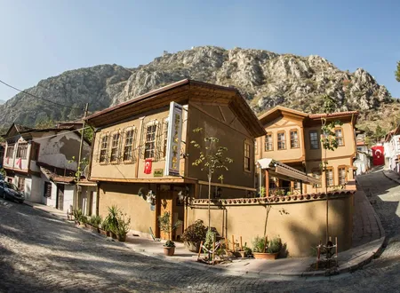
In Amasya, the importance of a neighborhood is often measured by the layers that have accumulated above and below the ground, with population a secondary matter. Şamlar is a good example. Only about a thousand people live there today, and it is not counted among the city's large districts, yet a complex built in the late fifteenth century by a palace official still stands within it. Nearby, a Roman-era city of the dead came to light in a rescue excavation in 1986. Between these two extremes lie tombs linked to the Danishmendid lords, a Halveti dervish lodge, a madrasa that produced teachers and imams for centuries, and a tomb built in the nineteenth century by a grand vizier for his father. The neighborhood's past can be traced largely through Hüseyin Hüsâmeddîn Yasar's Amasya Tarihi (History of Amasya), excavation reports and architectural studies, and there are not a few places where these sources disagree with one another.
Origin of the Name
In the old registers the neighborhood is called Şamlılar Mahallesi, "the quarter of the people of Damascus"; in common speech the name was gradually shortened to Şamlar. Hüsameddin explains its origin with a detailed story. According to him, the place was once known as "Dânişmendli Mülkü", the Danishmendid estate, because the Danishmendid Melik İsmâil had lived there. In the year 791 of the Hijra (1389), during the internal strife in Egypt between the partisans of al-Malik al-Ashraf Sha'ban and al-Malik al-Zahir Barquq, the Damascenes who had supported al-Ashraf were forced to leave their homes; some of them took refuge in Amasya and were settled in this quarter. The neighborhood then came to be called after them.
Local historiography offers a second explanation for the same name. As Hüsameddin reports, Mustafa Vâzıh Efendi, who had written a history of Amasya, stated that Damascenes who came to Amasya in the Umayyad period had lived here. Hüsameddin rejects this view in firm terms and counts it among Vâzıh's "oddities". Osman Fevzi Olcay, however, follows Vâzıh's line in his Amasya Hâtıraları (Memories of Amasya): the quarter where people who fled Damascus, unable to bear Umayyad oppression, settled was first called "Şamlılar" and later "Şamlar". Two separate migration stories thus exist for the same name. No archival document showing which of them is correct was found in the course of this study; both explanations should be read as the accounts of local historians. What is certain is that the name is borne today by both the neighborhood and its mosque. The mosque is called the Şamlar Mosque after its district and the Ayas Ağa Mosque after its founder, and the Ministry of Culture and Tourism presents the building as the "Küçük Ağa Complex / Şamlar-Ayas Ağa Complex".
Location and Former Boundaries
Şamlar belongs to Amasya's central district. Hüsameddin gives its boundaries in his own time as follows: the quarter lies on the north side of the Kuşköprü bridge, with the Yeşilırmak river to the east, a cemetery to the west, the foot of the Upper Citadel to the south and the vineyards known as Bahçeler İçi to the north. The description of the Şamlar Mosque's site in other sources as "at the foot of the citadel" agrees with this. The large cemetery to the west of the quarter appears in old records as the "Şamlar Cemetery", and most of the tombs described below stand at its edge or above it.
At the place called Gülüs, north of Şamlar, a new quarter was founded in the late 1870s by immigrants from Crimea. Registered officially as İhsaniye, the settlement was known to the people as the Tatar Quarter. Hüsameddin dates the arrival of the Tatars to 1295 of the Hijra (1878), while Olcay gives 1292 (1876/1877). According to Olcay, İhsaniye is a continuation of Şamlar and ends at the fork of the road leading to Kulis Tepesi and the town of Ziyaret; Şamlar itself lies at the foot of a fairly broad, commanding hill. Olcay also notes that in his day nearly all of Şamlar's residents were people who had moved there from various other parts of town. The relationship between these old descriptions and the neighborhood's present boundaries could not be verified in this study.
Danishmendid Traces and the First Mosque
According to the sources, the Islamic history of Şamlar begins with the Danishmendids. Hüsameddin writes that the records establish the existence of a mosque and tomb of Melik Gazi Bey in the quarter, and that these fell into ruin over time. A compilation based on İlhan Şahin and Feridun Emecen's article on Amasya in the TDV Encyclopedia of Islam likewise states that the oldest Islamic monument in the city was the mosque built by the Danishmendids in the twelfth century on the site of today's Şamlar Mosque, at the foot of the citadel. The same source records that the Fethiye Mosque was converted from a church into a mosque with the Danishmendid conquest in 1116, and that the Burmalı Minare Mosque was built in 1247. If this information is correct, the site of Şamlar is one of the places where the earliest traces of Islamic architecture in Amasya appear.
The only tangible trace of this first mosque that may survive is set in the wall of the present building. According to M. Baha Tanman's article in the TDV Encyclopedia of Islam, the arch tympanum of the window to the left of the minaret holds an inscription that cannot be fully read and probably dates from the Danishmendid period. It is the only known inscription on the building. It is reasonable to suppose that it is a fragment of the earlier mosque reset in the new structure, but this is an inference; since its text cannot be read, nothing can be said about whose name or what date it bears. No information at all has been found on the plan, size or appearance of the earlier mosque.
Two more tombs bearing the Danishmendid name are associated with the area around Şamlar. The very old Alagöz Baba Tomb, at the edge of the Şamlar Cemetery where a road branches off, belongs according to Hüsameddin to the Danishmendid lord İsmâil Gazi Bey, and its form recalls works of the sixth century of the Hijra (twelfth century AD). The tomb takes its name from Sheikh Şemseddîn Ahmed Baba, known as "Alagöz", who was buried there in 807 (1404-1405). Hüsameddin states plainly that apart from tradition he found no evidence or inscription showing that İsmâil Gazi lies in the tomb. The second is the Ayşe Gazi Tomb, north of the road leading to the Şirvânî Tomb in the quarter. In this square structure of dark stone, large enough for two graves, lie, according to local tradition, Gülnuş Banu, wife of Melik Danişmend Ahmed Gazi, founder of the Danishmendid state, and his daughter Ayşe Gazi. Hüsameddin notes that this too is "local tradition" and adds that other people were later buried in the tomb. The present condition of these two tombs could not be established in this study.
Ayas Ağa and the Founding of the Complex
The most important building still standing in the neighborhood is the complex built by Ayas Ağa, one of the kapı ağas of Bayezid II. The kapı ağas, the chiefs of the palace gate, were officials close to the sultan who controlled passage between the inner palace and the outside world. Ayas Ağa was one of Bayezid II's kapı ağas during the prince's governorship in Amasya. The sources call him the "Lesser Kapı Ağa" (Küçük Kapı Ağası), or simply "Küçük Ağa"; Hüseyin Ağa, known in the same period by the title "Greater Kapı Ağa" (Büyük Kapı Ağası), also built a madrasa in this quarter. Hüsameddin draws attention to this pairing and says that the two ağas together "revived this quarter". No detailed information on Ayas Ağa's life has been found; only his title, his endowments and the buildings he commissioned are known. In one place Hüsameddin calls him "Ayas Paşa"; in all other records his name is Ayas Ağa.
The complex has no inscription. Hüsameddin writes that in place of the ruined Melik Gazi Mosque, Ayas Ağa built in the year 900 of the Hijra (1494-1495) a stone mosque with a minaret beside it and a madrasa and a school in front of it, and set up their endowments. The Ministry of Culture and Tourism also dates the building to 1495. Yet the part of Hüsameddin's own work that narrates events year by year gives a different date: there it is recorded that in 890 (1485) the madrasas of the Greater Kapı Ağa Hüseyin Ağa and the Lesser Kapı Ağa Ayas Ağa in the Şamlılar quarter, together with Ayas Ağa's mosque, were completed, so that "Amasya flourished". With no inscription, the contradiction between the two dates cannot be resolved. Later research based on endowment records takes 1495 as the date.
A record of the complex's endowment survives, dated 1495, under the title "Ayas Ağa Vakfiyesi" in endowment register no. 582 in the archive of the General Directorate of Foundations. According to the reading cited by Sibel Yarar, Ayas Ağa built a bathhouse at the head of the Kunç bridge on a plot bought from Hoca Mehmed and Hoca Ahmed, known as "the son of Kocacık", and endowed it, together with the eight rooms on its eastern side, the channel of the water that flowed to the bath and from there to the river, and the garden through which this water ran, with all their rights, for the upkeep of the mosque and school he had built in the Şamlılar quarter. Hüsameddin adds to this endowment a mill in front of the gate of the Bayezid Paşa Mosque and says that the revenues were assigned to the mosque, madrasa and school at Şamlar. It is notable that the text of the deed names only the mosque and the school, not the madrasa; whether this is because the madrasa's endowment was arranged separately is not known.
The Endowment's Bathhouse: Kumacık Hamamı
The bathhouse Ayas Ağa built to provide income for his complex still stands. It lies on the opposite bank of the river, in the Bayezid Paşa neighborhood, facing the Kunç bridge and west of the Bayezid Paşa Mosque. Hüsameddin places it in line with the Kuşköprü bridge. Because the plot had belonged to the family nicknamed "Kocacık", the bath was first known as the Kocacık Hamamı; over time the name was corrupted into Kumacık or Komacık, and some old sources also call it the Ayas Ağa Hamamı. The fact that Mirza Beyzâde Mehmed Bey, a notable of Hakala, built a han on the road to the west of the bath in 990 (1582) shows that the building stood at a busy point in the city.
The bath consists of a nearly square, domed changing hall, a flat-ceilinged warm room laid out as a narrow corridor, and a hot room with four iwans and private cells in its corners. Rubble stone was used for the walls and cut stone at the corners, and the domes are covered with tiles. Although there are no written records of the changes the building underwent over the centuries, a plan dated 1930, two old photographs, one of them from 1957, and a restoration project begun in 1990 and continued for several years show that the warm and hot sections have not survived in their original form. According to Yarar's study of 2020, the bath was standing but closed for repair of its worn sections. The link between the complex at Şamlar and this bath across the river shows clearly how the Ottoman endowment system worked at the scale of a neighborhood: the lighting of the mosque and school, the teacher's salary and the repair of the buildings were paid for out of the rent of a bathhouse in another corner of the city.
Architecture of the Mosque
The buildings of the complex are arranged around a shared courtyard. Tanman notes that this layout continues the mosque-madrasa tradition of pre-Ottoman Anatolian Turkish architecture. The mosque, on the south side, consists of a square, single-domed prayer hall bounded by walls of rubble stone and brick, a three-bay portico, and a minaret rising at the northeast corner of the prayer hall. Closed to the east and west, the portico opens to the north through three arches resting on two piers. The side bays are square and covered with domes on pendentives; the arches opening into them are pointed, while the arch of the central bay is a Bursa arch. The face of the wall above the brick arches is covered with a decorative bond of cut stones framed by brick hexagons.
The sources differ on the covering of the central bay of the portico. The Ministry of Culture and Tourism's description says that this bay, narrower than the side bays, is covered by a mirror vault, while Tanman writes that the rectangular central unit is covered by a barrel vault. The prayer hall is lit by two windows, one above the other, on each side. The dome rests inside on a band of lozenges and outside on a tall twelve-sided drum pierced by three small windows. The lower windows have rectangular openings with frames of cut küfeki stone and pointed brick relieving arches; the pointed upper windows are fitted with plaster grilles. The mihrab and the wooden minbar are plain in appearance.
The minaret's base, projecting outward in a half-hexagon and laid in alternating courses of stone and brick, and its cut-stone footing survive from the original building; the brick shaft has been renewed. Hüsameddin preserves an important record bearing on the reason for this renewal. On the twenty-seventh day of Jumada al-awwal in the year 1147 (autumn 1734), a violent, rumbling earthquake struck Amasya toward the time of the afternoon prayer; the Bey Mosque and the Dizdariye Madrasa in the Upper Citadel, the minaret of the Ayas Ağa Mosque in the Şamlar quarter, the Hüseyin Ağa Madrasa, the Yakut Paşa bedesten, the Loğ Minaret and many stone houses partly collapsed. It is plausible that the present shaft was rebuilt after this earthquake, but no document dating the repair has been found, and the shaft may also have been renewed in a later restoration. The mosque underwent other repairs over time and remains in use for worship.
The Madrasa and the Primary School
The madrasa of the complex appears in the sources as the Medrese-i Ayasiyye, the Ayas Ağa Madrasa, the Küçük Kapı Ağası or the Küçük Ağa Madrasa. Hüsameddin describes it as a separate courtyard in front of the mosque, surrounding the mosque's north and west sides; it is a solid building of stone on all sides and was still in use in his day. Tanman's description agrees with this: the madrasa consists of nine cells enclosing the courtyard north of the mosque on its west and north sides, six to the north and three to the west. In front of the barrel-vaulted cells runs a portico of mirror vaults resting on marble columns and round arches, and the porticoes and cells are brought under a common timber roof. Tanman suggests that the section adjoining the west end of the mosque's portico was the lecture hall.
The Ministry of Culture and Tourism's description, however, paints a different picture. According to it, the rooms surround the courtyard on three sides, following the U-shaped layout of classical Ottoman complexes; along the sides run porticoes covered by thirteen domes carried on twelve plain-capitalled cylindrical columns, the columns are joined by round brick arches, each room has a hearth and a cupboard, and the madrasa has no separate lecture hall. These differences over the portico covering, the number of cells and the lecture hall may stem from the sources describing the building in different periods or after different repairs; this is a conjecture and cannot be confirmed without seeing the restoration records. Both sources agree that the somewhat larger section at the eastern end of the row of cells was the primary school. According to Tanman, the school consists of two barrel-vaulted spaces: the eastern one contains the entrance, the western one a hearth and two cupboard niches. This section is used today as a library.
The school has a history of its own. Hüsameddin lists it among Amasya's old primary schools as the "Küçük Ağa Mektebi", describes it as an orderly, elegant stone building, and records that in 1327 (1909-1910) it began to be used as a state primary school (mekteb-i ibtidaî). The smallest unit of the complex thus became, more than four centuries after its founding, a place of modern education as well.
The Madrasa's Teachers
In the Ottoman madrasa system, the Ayas Ağa Madrasa stood at the rank of "hamsîn", the fifty-akçe madrasas, in the ranking based on the teacher's daily salary. This placed it one step below the city's great madrasas; according to Hüsameddin, its neighbor the Büyük Ağa Madrasa was of the "sittîn", or sixty-akçe, rank and among Amasya's first-class madrasas. The name of the madrasa's first teacher appears in Hüsameddin in two different forms: in the section on madrasas he is "Şamlızâde Tâceddîn İbrâhim Efendi", in the year-by-year chronicle "Horasânlıoğlu es-Seyyid Tâceddîn İbrâhim Efendi". The second teacher was Şemseddîn Ahmed Efendi, nicknamed "Emîr Kulu". The biography of one of his students, Sinâneddîn Yûsuf Efendi, reflects the atmosphere of the madrasa in the early sixteenth century: born in the Kurşunlu quarter in 893 (1488), Yusuf Efendi lodged at the Büyük Ağa Madrasa while studying under Emir Kulu, the Küçük Ağa teacher, and then under Taşköprülü Muslihüddin Mustafa Efendi, who came to teach at Büyük Ağa, and in 918 (1512) he went with him to Istanbul. On this evidence, the two ağa madrasas at Şamlar functioned like a single circle of learning in which students moved from one to the other.
After Emir Kulu moved to Istanbul, in Hüsameddin's words "a great many scholars" taught at this madrasa and rose to the rank of mevleviyet, the senior judgeships. In the seventeenth and eighteenth centuries the teaching post was at times divided in two, with half-shares passing from father to son. Hüsameddin's list includes names such as Pîrî Efendizâde Hâfız Hüseyin Efendi in 1086 (1675-1676), Çorumlu Hâfız es-Seyyid Mehmed Efendi in 1132 (1720), Şerîfzâde es-Seyyid el-Hâc Mustafa Efendi in 1173 (1759-1760) and Şeyhzâde es-Seyyid Abdullah Vecîh Efendi, who became sole teacher in 1195 (1780-1781); Hüsameddin writes that after Vecîh Efendi the teaching share remained with his descendants here, as at Büyük Ağa. The biographical volumes of the same work also show several scholars who rose from the Ayas Ağa professorship to the office of mufti of Amasya; Hocazâde Mehmed Efendi and Çorumlu Hacı Ali Efendi, both teachers at Ayas Ağa, became muftis by this route. Hasan Telli's study based on the Meşihat Archive lists the Küçük Ağa (Ayas Ağa) Madrasa among the madrasas still teaching in Amasya in the twentieth century.
A note in Olcay's memoirs also belongs to this last period. Under the heading "Şamlar (Şamlılar) Madrasa", Olcay apologizes to his readers for being unable to give solid information about the founder; the absence of any mark or inscription on the building had left him uncertain. In his day the madrasa's teacher was a man known as Ardahanlı Hoca Efendi, but Olcay says that since the quarter was not his own, he did not know what was taught there or who the students were. It is very likely that the building Olcay refers to is the uninscribed Ayas Ağa Madrasa, but since the name Ayas Ağa does not appear in his text, this remains an inference.
The Graveyard
Between the mosque and the primary school there is a small graveyard. It holds eight graves of simple workmanship. Most of them have been damaged over time and none bears an inscription. Some show geometric patterns and motifs of flowers and swords. Since they have no inscriptions, it is impossible to say whose graves they are.
The Şamlar Lodge and the Sheikhs of the Quarter
In the mid-sixteenth century a dervish lodge was also founded near the complex. According to Hüsameddin, the Şamlar Lodge was built in 951 (1544-1545) by Hoca el-Hâc Sâlih Çelebi, one of the city's notables, who also set up its endowments. For a long time Halveti sheikhs presided over the lodge. From 1231 (1815-1816) onward, Sheikh Turâbî Ali Efendi, one of the deputies of Sheikh Yûsuf Nakşbendî, served as sheikh here and spread the Naqshbandi path. Whether the lodge still stands and its exact location could not be established in this study.
The lodge's best-known sheikh is Sâlih Efendi, called the "Sheikh of Şamlar". According to Hüsameddin's biographical entry, Sâlih Efendi was the son of Hasan, a resident of the Şamlılar quarter. He was one of the deputies of the Halveti sheikh Hüsameddîn Halvetî; he turned his house in the quarter into a zawiya and became the pulpit preacher of the Ayas Ağa Mosque. Because his breath was believed to have healing power, he was also appointed sheikh of the Bimarhane, Amasya's hospital (Darüşşifa), and he is said to have helped the mentally ill recover by reciting prayers over them. He is said to have treated patients "in body and spirit" together with the hospital's physician, Hekimzâde Mahmud Çelebi. He accepted nothing from anyone and contented himself with the daily allowance paid to him from the Ayas Ağa and Bimarhane endowments. His biographical entry gives his death as the month of Dhu al-Hijja in 1078 (1668), while Hüsameddin's section on the hospital gives approximately 1076. The sheikh was buried in his well-known cell inside the hospital.
The pulpit preachership and imamate of the Ayas Ağa Mosque can be traced through other names in Hüsameddin's biographical volumes. Gümüşlü Süleyman Efendi, after becoming teacher at the Ayas Ağa Madrasa, lived for a long time in the Şamlılar quarter and died in 1105 (1693-1694) as the mosque's pulpit preacher. Hacı Kasımoğlu es-Seyyid Hüseyin Efendi was the son of Ali, the mosque's muezzin; in 1100 (1688-1689) he became imam of the mosque on a joint petition of the scholars of Amasya. İmam Hoca İbrâhim Efendi became imam in 1129 (1716-1717) and then pulpit preacher; when he died in 1147 his son es-Seyyid Mehmed Efendi succeeded him, and he in turn ceded the imamate to Hâfız Ali Efendi in 1156. These records show that the offices of the neighborhood mosque often stayed in the same families, and that there was constant movement between madrasa and mosque.
The Büyük Ağa Madrasa and Other Buildings of the Quarter
According to Hüsameddin's description, the second great madrasa of the Şamlılar quarter is the Büyük Ağa Madrasa, on the road at the head of the vineyards called Bahçeler İçi. Built in 894 (1488-1489) by Hüseyin Ağa, kapı ağa of Bayezid II in Amasya, this madrasa was a very solid building, of stone on every side, with spacious cells and an excellent lecture hall. The Arabic inscription on it states that the building was among Hüseyin Ağa's charitable works and was completed in 894; for this reason the madrasa is also called the "Medrese-i Hüseyniyye". Among the madrasa's extensive endowments was Amasya's famous bedesten. Hüsameddin writes that in his day the madrasa stood in a ruined state that "grieved everyone". The Büyük Ağa Madrasa is known today as a separate monument; whether it lies within the present-day boundaries of the neighborhood could not be verified in this study.
The buildings on the cemetery side of the quarter extend into the nineteenth century. Above the Şamlar Cemetery, within a walled enclosure, the Şirvânî Tomb consists of two stone domes; the western part is a small mosque and the eastern part the tomb. The former grand vizier Şirvânîzâde Mehmed Rüşdü Paşa built it in 1286 (1869-1870) and set up its endowment in 1290 (1873-1874). Inside lie the paşa's father, Sheikh İsmâil Sirâceddîn Şirvânî, his brother es-Seyyid Ahmed Hulûsi Efendi, a former judge of Istanbul, and his brother-in-law el-Hâc Îsâ Rûhî Efendi. Olcay, too, lists "Mevlâna Sirâceddin İsmail Şirvânî" among the eminent figures buried in Amasya and gives his resting place as the Şamlar quarter.
Hüsameddin's list of tombs includes one more structure linked to the Şamlılar quarter. In the Safâ Paşa Hatun Tomb, a small walled plot behind the large fountain on the main road, lies, according to old documents, Safâ Paşa Hatun, daughter of Şadgeldi Paşa, emir of Amasya. Beside her is buried Yahşi Bey, thought to have been her husband. Mustafa Vâzıh Efendi, the historian whom Hüsameddin criticizes over the origin of the neighborhood's name, was also buried next to them at his own request. That the historian who traced Şamlar's name to an Umayyad-era migration lies in this very quarter is a small but striking detail.
The Latin Inscription by the Kuşköprü Bridge
Şamlar's connection with the Roman era is not known from excavations alone. In his list of Roman inscriptions, Hüsameddin writes that a Latin text was "reported" on a rock at the head of the Kuşköprü bridge, southeast of the Şamlar quarter, on the riverbank behind what was then the tannery. According to the translation he gives, the inscription says that Rufis, head of the family, who adorned the rock in his lifetime, built this tomb for his son Kıleobrat, who had drawn up the laws; that his own bones were placed here when he died; and that Timeyis Kıroniyon and his son Palikaruniyos also lie here. Hüsameddin does not say that he read the inscription himself and gives the information as a report; the spelling of the names, coming from a reading made in Ottoman script, cannot be considered reliable either. Whether the inscription is still in place, and what its original text was, could not be established in this study. Even so, the reported content, together with the necropolis described below, strengthens the impression that the area around Şamlar was used as a burial ground in the Roman period.
The Old Şamlar Cemetery and the Late Roman Necropolis
The best-documented aspect of the neighborhood may well lie underground. Mehmet Tektaş, director of the Amasya Museum, gives the details of the work in his "Amasya Merkez Eski Şamlar Mezarlığı 1986 Kurtarma Kazısı Raporu" (Report on the 1986 Rescue Excavation at the Old Şamlar Cemetery, Central Amasya), published in Belleten (1988). The excavation, approved by order of the Ministry of Culture and Tourism's General Directorate of Antiquities and Museums dated 3 March 1986, was carried out under Tektaş's direction with museum researcher Ahmet Yüce and several staff members; it began on 22 April 1986 and was completed on 21 May 1986. The work lasted 29 days and employed an average of ten workers.
The site had been used as a Muslim cemetery until recent years. The Municipality of Amasya had declared it a zone for housing and for the prevention of squatter construction, and a 60 x 20 meter section was allocated to the Police Directorate for the construction of police housing. In April 1985 a 50-meter trench was cut on a north-south line with a tracked loader for a ground survey, and when graves appeared in this trench a rescue excavation was called for. Because the budget was insufficient, the work was carried out in only one corner of the site, an area of about 200 square meters, and was then stopped. As the report explains, since the means available for this first excavation would not cover the whole site, the northern end, close to the middle of the necropolis area, was chosen in the expectation of obtaining quicker and more definite results.
During the digging, more than thirty Muslim graves were uncovered at various levels. As the work went deeper, a hard layer of earth packed with pebbles and large pieces of stone appeared in the central area, where a small stream bed was thought likely to have run. The main finds lay beneath this. To the east of a wall remnant of rubble masonry, 0.90 meters thick and running north-south, two children's graves edged with brick and rubble were found. The Muslim graves above had damaged them, and because the bones had almost completely decayed, the orientation of the skeletons could not be determined. The fact that the graves pointed in different directions, however, shows that they were not Muslim burials.
Beneath these, six adjoining groups of graves were found. Bounded by rubble stone, topped with a course of brick and plastered smooth on the inside in a slightly reddish color, these graves were covered with cut-stone lids of the limestone known as küfeki. The lids of three of the east-west graves were found in place, but it became clear that all of them had been robbed long ago and partly destroyed. The soil of one grave yielded nothing but fragments of glass tear bottles (unguentaria).
In the grid square to the south lay a more carefully built pair of graves (4C-1 and 4C-2). They were edged with rubble, topped with bricks measuring 30 x 40 centimeters, and plastered inside in a reddish color; they lay parallel and symmetrical about an axis, and the partition between them was raised with courses of brick. These too had been robbed. In one, a skeleton survived from the knees down, and the architecture of the grave showed that the dead had been buried with the head to the north. A multi-fragment terracotta tear bottle came from the head end of one grave of the pair, and four terracotta bottles and a multi-fragment white glass bottle from the foot of the other. A third grave with the same features (4C-3) was found 0.60 meters deeper than the pair, but it yielded nothing except fragments of a thin-walled, red-slipped jug. A simple earth grave without architectural features (4C-4) had also been covered with bricks; in this one, unlike the others, the dead had been laid with the head to the south.
Graves visible in section on the eastern face of the trench were reached by cutting in from the side. Here relatively large graves (2D and 3D) were found, thought to have had a vault-shaped covering narrowing upward, and in each of them two bodies had been buried on an east-west line. The double grave in the seventh grid square (7D) was bordered by two limestone blocks on each side and divided down the middle by courses of 30 x 40 centimeter bricks. Its interior was coated with fine plaster and decorated with red, segmented, symmetrical garlands, with stylized floral motifs set between them. The report notes that this grave shares the features of the graves found about 400 meters to the north at Kulistepe in a rescue excavation carried out by the Amasya Museum in 1974.
Tektaş's conclusions at the end of the excavation were as follows. The function of the north-south wall could not be determined with certainty. All the graves had been robbed and some had been destroyed. No consistent principle could be seen in the orientation of the graves or in the way the dead were laid out. Different examples emerged in terms of the materials and techniques used. The grave structures and finds showed that before the site served as a Muslim cemetery it had been used for the same purpose, that a necropolis had existed here, and that this necropolis had Late Roman characteristics. The report further states that in 1983, during construction work 30 meters north of the site, similar graves had been found, and in lower layers large graves of rubble masonry with vaulted covers, grouped in twos and threes. Taken together with the 1974 excavation at Kulistepe, this strengthened the view that the necropolis extended from south to north over a broad area now lying beneath the railway and residential districts. Tektaş adds that the most definite and scholarly conclusions could be obtained only if the excavation were continued.
Another document mentioned in the report is the manuscript Amasya Tarihi Zeyli (Supplement to the History of Amasya) written by Osman Fevzi Olcay in 1932. In it Olcay mentioned "the sarcophagi that came to light in the Şamlar neighborhood" and also drew a sketch. Taking into account that the railway passed through Amasya around 1924-1925, Tektaş concludes that these sarcophagi were the vaulted grave groups of twos and threes that appeared beside the railway. The neighborhood's underground past was thus recorded on three separate occasions: by the railway cutting of the 1920s, the manuscript of the 1930s and the rescue excavation of the 1980s.
The Layers of Şamlar
Set side by side, these findings show that Şamlar has a long history of use. At the bottom lies a Late Roman necropolis; the fact that the excavated graves had been robbed shows that the area was disturbed by human hands at a very early date. The Latin funerary inscription on the rock near the Kuşköprü bridge, reported by Hüsameddin, points to the same period. Above this come a mosque, tombs and traditions linked to the Danishmendid lords; then, at the end of the fifteenth century, the madrasas built by two palace ağas turned the quarter into a district of learning. A dervish lodge was added in the mid-sixteenth century and a grand vizier's family tomb in the nineteenth, and the cemetery remained in use until recent years. For the intervals between these periods, especially the Byzantine centuries and the time between the Danishmendid and Ottoman eras, we have almost no documents showing what the neighborhood looked like. It is reasonable to suppose that settlement and cemetery replaced each other over the centuries, but this is an inference and is not supported by documents.
Clearer information exists on the general state of Amasya in the Ottoman period. In the sixteenth century the city is recorded as having 55 quarters, nine mosques, ten madrasas, four zawiyas, six soup kitchens and fifteen bathhouses. The traveler G. Perrot, who came to the city in 1861, called Amasya "the Oxford of Anatolia" because some 2,000 students were studying in the madrasas of a city of about 25,000 people. The rooms of the two ağa madrasas at Şamlar must have housed part of this crowd of students. No record has been found, however, of how many students stayed here in which years.
Population
One of the compilation websites on neighborhood populations gives the current population of Şamlar as 1,082, of whom roughly 48.7 percent are male and 51.3 percent female. The year of the data is not clearly stated. The figure should therefore not be taken as official TÜİK (Turkish Statistical Institute) data but read as an approximate value. No series of neighborhood population figures for earlier years could be found.
Şamlar Today
Today Şamlar, with its complex, its primary school turned library and its quiet streets, is one of Amasya's quieter neighborhoods. The Ayas Ağa Mosque is open for worship, and the complex is included in the Ministry of Culture and Tourism's promotion of faith tourism. The same compilation website describes the neighborhood as strong in green spaces and limited in social life; this is the opinion of a compilation site and is not a historical finding. The Kumacık bathhouse, built to provide income for the complex, still stands on the other bank of the river. The site of the Old Şamlar Cemetery now lies within a residential area, and the 1986 excavation opened only a small part of it. As the excavation report itself notes, most of the necropolis lies beneath the railway and newer buildings.
Chronology
12th century: A mosque attributed to the Danishmendids stands on the site of today's Şamlar Mosque; Hüsameddin records it as the mosque and tomb of Melik Gazi Bey.
791 (1389): According to Hüsameddin, some of the Damascenes who left their homes during the internal strife in Egypt settle in this quarter of Amasya (account of a local historian).
807 (1404-1405): Sheikh Şemseddîn Ahmed "Alagöz" Baba is buried in the old tomb at the edge of the Şamlar Cemetery.
890 (1485): According to Hüsameddin's year-by-year chronicle, the madrasas of Hüseyin Ağa and Ayas Ağa in the Şamlılar quarter and the Ayas Ağa Mosque are completed (another passage of the same work gives the date 900).
894 (1488-1489): The Greater Kapı Ağa Hüseyin Ağa builds the Büyük Ağa Madrasa.
900 (1494-1495): The Lesser Kapı Ağa Ayas Ağa builds the Şamlar Complex (mosque, madrasa, primary school, graveyard) and the Kocacık (Kumacık) bathhouse to provide its income; the endowment record is dated 1495.
951 (1544-1545): Hoca el-Hâc Sâlih Çelebi builds the Şamlar Lodge.
1078 (1668): Sâlih Efendi, pulpit preacher of the Ayas Ağa Mosque and sheikh of the hospital, dies.
1147 (1734): In an earthquake in Amasya, the minaret of the Ayas Ağa Mosque and the Hüseyin Ağa Madrasa partly collapse.
1231 (1815-1816): Sheikh Turâbî Ali Efendi begins his Naqshbandi sheikhdom at the Şamlar Lodge.
1286 (1869-1870): Şirvânîzâde Mehmed Rüşdü Paşa builds the Şirvânî Tomb above the Şamlar Cemetery.
c. 1876-1878: Tatars from Crimea found the İhsaniye (Tatar) quarter at Gülüs, north of Şamlar.
1327 (1909-1910): The Küçük Ağa school begins to be used as a state primary school.
c. 1924-1925: The railway passes through Amasya; vaulted grave groups become visible in the cutting.
1932: Osman Fevzi Olcay's manuscript mentions sarcophagi in the Şamlar area.
1974: A rescue excavation is carried out at Kulistepe, about 400 meters to the north.
1983: Similar graves are found during construction work 30 meters north of the Old Şamlar Cemetery.
22 April - 21 May 1986: A rescue excavation is carried out at the Old Şamlar Cemetery, identifying the site as a Late Roman necropolis.
1988: The excavation report is published in Belleten.
1990: A restoration project is prepared for the Kumacık bathhouse; the work continues for several years.
Bibliography
Primary sources
- Hüseyin Hüsâmeddîn Yasar, Amasya Tarihi, vols. 1-4, pp. 110, 113, 123-124, 133, 135, 139, 142-143, 152, 162, 166-167, 175-176, 287, 482, 515, 637, 645, 652 (amasya.bel.tr e-book).
- Hüseyin Hüsâmeddîn Yasar, Amasya Tarihi, vols. 9-12, pp. 39, 300, 319, 434; vols. 6-8, p. 54 (amasya.bel.tr e-book).
- Osman Fevzi Olcay, Amasya Hâtıraları. Bildiklerim-Gördüklerim-İşittiklerim İle Amasya, Amasya Municipality Cultural Publications (sections "Şamlar Mahallesi", "İhsaniye Mahallesi", "Şamlar (Şamlılar) Medresesi"). amasya.bel.tr
Academic studies
- M. Baha Tanman, "Ayas Ağa Külliyesi", TDV İslâm Ansiklopedisi, vol. 4, Istanbul 1991, pp. 201-202 (islamansiklopedisi.org.tr).
- Sibel Yarar, "Amasya Kumacık Hamamının İlk İnşasındaki Planına Dair Bir Değerlendirme", Vakıflar Dergisi, no. 54 (December 2020), pp. 185-200 (dergipark.org.tr).
- Hasan Telli, "Meşîhat Arşivi'ne Göre Amasya Müderrisleri", Kocatepe İslami İlimler Dergisi, vol. 7, no. 2 (2024), pp. 732-758 (dergipark.org.tr).
- Mehmet Tektaş, "Amasya Merkez Eski Şamlar Mezarlığı 1986 Kurtarma Kazısı Raporu", Belleten, vol. 52, no. 205 (1988), pp. 1715-1720 (belleten.gov.tr).
Official sources
Other sources
- İslam Düşüncesi Atlası (Atlas of Islamic Thought), "Amasya" page (based on İlhan Şahin and Feridun Emecen, "Amasya", DİA, vol. 3, 1991) (islamdusunceatlasi.org).
- hangisemt.com, "Şamlar Mahallesi Nerede, Hangi İlçeye Bağlı?" (population; year not stated).
Online sources