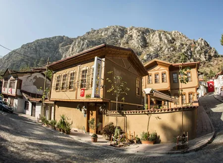
While Amasya's crowded historic core is squeezed into the Yeşilırmak valley, Yazıbağları lies to the west of the city, in the belt of vineyards that opens from the eastern foot of Karaman Mountain toward the river. Written sources on the neighbourhood are few and scattered. Most of the documented information rests on the "Yazı Bağları" entry that Hüseyin Hüsameddin Yasar lists among the endowments of İltekin Gazi in his Amasya Tarihi, on his description of the vineyards, bridge and tomb around that entry, and on the railway, barracks and school that arrived in the Republican period. For the centuries in between, nothing can be said with certainty. The account below stays within that limit, and inferences drawn from the sources are marked as inferences.
Origin of the Name
In official records and on maps the neighbourhood appears both as Yazıbağları and as Yazı Bağları. The name looks like a compound of "yazı" (plain, flatland) and "bağ" (vineyard). This is an inference from the known meanings of the words; no document or etymological study stating the exact origin has been found. In Yasar's work the name already appears as an established place name of his own day. In Amasya, the vineyards on both banks of the river were named after their location, their owners and the buildings near them, and Yazı Bağları belongs to that system of naming.
The only supporting record on the administrative history of the name comes from a study of renamed settlements in Amasya. Among the former villages of the central district later turned into neighbourhoods, it lists Yazıbağları together with Boğazköy, Fındıklı, Helvacı, Karasenir, Orman Bağları, Saraycık, Yeniköy and Yeşilyenice. In other words, the present neighbourhood is less an old quarter of the city than a settlement that acquired neighbourhood status as the administrative order changed. The study gives neither the year nor the reason for the change.
Vineyards at the Foot of Karaman Mountain
Yasar speaks of a lightly wooded mountain called "Karaman Dağı" on the western side of Amasya, running from north to south. He links its name to Karamanzade Yahşi Bey, who was charged with seizing Gümüşlüzade Tâceddin Mahmud Çelebi at the request of the Egyptian Turkmens in the year 727 and who crossed into Amasya over this mountain; but he presents this as a guess, not as established fact. The mountain extends as far as the head of Çalan Bridge at the end of the southern gorge; its western face looks toward the Geldiklan plain and its eastern face toward the city of Amasya.
On the eastern slope, in the places lying south of the Şeyh Cûî locality, the name "Akbilek" is used. It spread from the year 931 onward because the Hanafi scholar and eminent exegete Molla Bahşî Halife was buried south of the vineyards. Yasar describes the Akbilek Vineyards as a rectangle running from north to south, enclosed by a wall, once a single large vineyard that he supposes was later divided into parcels. Above Akbilek, all the vineyards and slopes on the eastern foot of the mountain are called "İltekin" in general. That an Akbilek Bağları Mosque stands on Kışla Street in today's neighbourhood shows that the old vineyard name is still alive.
Yasar's survey of the vineyards along the river helps to place Yazıbağları. On the southern bank the sequence runs westward from the Sultan Bayezid Mosque through İnehân, Yörgüç Paşa, Hacılar Meydanı, Ferhad Arası and Çalan Köprü; on the northern bank, starting from the northern shore of Meydan Bridge, come Ok Meydanı and then the İltekin Vineyards, which continue to the head of Çalan Bridge. In the table of contents of Osman Fevzi Olcay's Amasya Hâtıraları, too, the vineyards chapter lists Akbilek, Şeyh Cûî, Alp Tekin and Helvacı and then, in a single line, "Çalan Köprü Bağları, Yazı Bağları, Dadı Önü Bağları, Ağ Burun Ucu Bağları, Güllük Serçoban Bağları, Kızılca Bağları". The body text of this chapter is missing from the file at hand, so its detail cannot be reported; the order does suggest, however, that Yazı Bağları was named at the western end of the city, in the vineyard belt toward Çalan Bridge.
Yasar describes these vineyards with affection. He writes that Amasya's vineyards span a distance of eighteen hours' walk from one end to the other along the river, and that hundreds of waterwheels irrigate them. He notes that the Yeşilırmak swells from early March and sometimes floods the vineyards and the city, and delivers the verdict: "if it swells it is a delight, if it overflows it is a blessing, its flowing is a grace of mercy." The sentence reflects the outlook of the vine-grower who lived on the river bank through the centuries despite its floods; the same area is mentioned in news about flood risk today.
İltekin Gazi and the Endowment Record
According to Yasar, İltekin Gazi was one of the Danishmendid emirs and belonged to the Khwarazmian Turkmens, a claim he bases on the Tarih-i Âl-i Dânişmend. During the conquest he entered Amasya from this side, destroyed Kelkis Castle, and was later buried here. This is the reason the area is called İltekin. Yasar writes that the name has appeared in official records since the year 567; because no calendar is given, this number has not been converted into a Gregorian year.
Across different parts of Yasar's book İltekin's identity is not given in exactly the same form. In one place he is "of the Khwarazmian Turkmens", in another "Nâsırüddevle İltekin el-Artukî", and in the section on descendants "Nâsırüddevle İltekin Harezmî". Yasar draws no distinction between these designations; the contradiction stands in the book as it is. The common ground is nevertheless clear: İltekin was one of the Danishmendid emirs, one of the conquerors of Amasya, and his grave is in the tomb on the slopes of the neighbourhood. In the section on his descendants the family divides into three branches: the branch of Gıyâseddin Mahmud remained in Konya, that of Hüsâmeddin Hüseyin Rûmî in Egypt, and only the "Aydın" branch multiplied in Amasya. A "Kağnı" offshoot later emerged from this branch, and its members could still be found until the year 1100; Aydın Paşa, Ali and Hasan Beys were the well-known members.
The tomb of İltekin Gazi, in Yasar's description, is an old stone dome resting on four stone columns, above the İltekin Vineyards at the foot of the mountain. In another section Yasar writes that the tomb holds the Danishmendid vizier Nâsırüddevle İltekin el-Artukî and his son Emir Hüsâmüddevle Hasan Gazi. Beside it stands the tomb of Cihan Hatun, known as "Kadem Paşa" and said to be the daughter of the Amasya emir Şadgeldi Paşa; she has endowments and recitation funds of her own. An old grave of unknown identity is also seen at the same spot. Yasar dismisses what Vâzıh Efendi reported about Cihan Hatun as sheer fable. Behind the tomb are heaps of stones and the remains of old walls, pointed out as the ruins of Kelkis Castle. According to a tradition Yasar records, a stone cavity behind the tomb leads to a path descending on the left, which passes under the river at Ferhad Arası and reaches Kelkis Castle. Yasar reports that a party lit candles and advanced about thirty metres, but turned back as the saltpetre effect grew stronger.
Another record about İltekin's family touches on dynastic history. For the tomb of Efrumiye Bânû, on a hill above the Gökmedrese Mosque, local tradition says that the daughter of Jutatyus, the last Byzantine governor of Amasya, and wife of İltekin Gazi, the conqueror of Amasya, lies there. Legal documents show that her son Emir Hüsâmüddevle Hasan Gazi had endowments and Qur'an-recitation funds. In Yasar's biographical volumes, Hüseyin Gazi Bey (Sehmüddevle), born of Efrumiye Bânû, appears as İltekin's second son; he served as emir in Merzifon, built a mosque there and endowed his Sehmüddevle farm for the mosque's expenses. Yasar writes that Merzifon too was conquered by İltekin Gazi. These records are given as local tradition together with documents; placing them in a chronological order has not been possible.
Yasar's sentence that deals directly with Yazıbağları is this: "Yazı Bâğları ve Karasenir Mahallesi umûmen Gâzi-i müşârün-ileyhin vakfı olup, 1160 târîhine kadar evlâdı tevliyet tarîkiyle tasarruf etmekdeler idi." That is, Yazı Bağları and neighbouring Karasenir were regarded as the endowment of İltekin Gazi, and until the date given its administration remained in the hands of the Gazi's descendants as trustees. The text does not say which calendar the number 1160 belongs to. The sentence suggests that Yazı Bağları has been known since then as a vineyard tract and endowment land; but this too is an inference.
Simre and the Old Settlement around the Tomb
The surroundings described by Yasar also show that this endowment tract was once a lively settlement. The area around the tomb was once a whole quarter and, according to records dated 1052, the centre of a new town called "Simre". By the time Yasar wrote, this quarter no longer existed; its mosque, two small mosques and a school had disappeared, and their endowments had passed to the treasury. The vineyards in front of it have been famous since early times, and the vine-growers are said to hold İltekin Gazi in particular reverence.
The name Simre is a subject that occupied Yasar at length. He writes that the Seljuk sultan Mesud founded Simre in Amasya and repaired the city anew; but he also records that old documents mention six different Simres, for Amasya, Alparslan, Havza, Koca Kayas, Lâdik and one more place, and that the name is written in the sources in various forms such as Sümre, Saymere and Sâmere. For the Geldiklan district he writes that, once Seljuk influence in Amasya ended, it was counted as the "Simre District" and its centre was made the "village of İltekin". The area around the tomb of İltekin may therefore have been a village or town that for a time also served as a district centre; but since no documents are cited, the date of this foundation cannot be fixed.
A custom of pilgrimage is also tied to this area. The people of Amasya had made it a habit to visit the grave in large groups early in every month of Sha'ban. In a footnote Yasar adds that it is widely reported that the Gazi entered Amasya on the second day of Sha'ban, so that the visit was regarded as an old custom peculiar to Amasya, and he bases the account on Şeyhzade Hacı Ali Efendi, who told it from his father and from his own observation. The same footnote says that after "42" many fine national customs were abandoned and that this visit was later abandoned too.
Çalan Bridge
The boundary marker of the vineyard belt at the western end of Yazıbağları is Çalan Bridge. According to Yasar there are six bridges in the Amasya valley; four are of cut stone and two of timber, and none dates from ancient times. Among them, Çalan Bridge stands at the end of the southern gorge, that is, of Ferhad Arası. Its foundation, top and sides are of stone, its arches and piers of red brick. Because a small square chamber-like projection stands in the middle of its southern side, it was called "Çalan" from "Çalak", meaning "crooked".
According to Yasar the bridge is recorded in old documents under the name "İltekin Bridge", and from this record it is understood that it was built by İltekin Gazi, who lies buried on its downstream side. In the same place he supposes, judging by the foundation stone, that a bridge had stood there earlier, and that it was rebuilt in the Danishmendid period after it fell into ruin. He adds that most old buildings of red brick belong to this period, as he infers from similar examples. The source draws the distinction clearly here: the record ties the bridge to İltekin, while observation points to an older foundation.
Eryatağı Station
In the Republican period the most conspicuous mark on the neighbourhood has been the railway. Eryatağı Railway Station was built on the Samsun-Kalın line by the State Railways and Ports Administration and entered service in 1927. The line as a whole is the product of a construction process that began in 1926 and was completed in 1932; the 378-kilometre line joins Samsun to the Ankara-Kars line at Kalın. The station belongs to TCDD, has a single side platform and three tracks, serves no passenger trains today and is used only for freight. The line underwent a wide-ranging renovation between 2015 and 2020, and passenger services resumed in 2023; but Eryatağı is not a stop on these services.
No explanation of the word "Eryatağı" in the station's name has been found in the sources. Whether the name is a place name from the neighbourhood or a separate name given to the station is not known.
Barracks and School
The building that gives the neighbourhood its recent identity is the barracks. The 15th Infantry Training Brigade Command is stationed at General Hikmet Akıncı Barracks, on Kışla Street in Yazıbağları. The brigade brings together the 12th and 22nd Infantry Training Regiments in Amasya and a non-commissioned officers' training company in Samsun; the basic training of privates and corporals is carried out here. A guide to military units states that the barracks was established in 1974 at the Yazı Bağları locality; this date could not be confirmed by another document. No biography of Brigadier General Hikmet Akıncı, after whom the barracks is named, appears in the sources, and for that reason none is given.
The Tuğgeneral Hikmet Akıncı Middle School next to the barracks is also within the neighbourhood; its address is given as "next to the brigade lodgings", and the school operates today with six classrooms, ten teachers and one hundred and four students. Within the neighbourhood there is also a Yazıbağları Mahallesi Mosque on Yazı Bağları Street; no record of its date of foundation has been found. The neighbourhood, in other words, has become a settlement shaped around a military installation and the housing population around it, in addition to its historic vineyard character.
The River Bank and Floods
Because Yazıbağları lies on the bank of the Yeşilırmak, it is directly affected by the river's rising. In June 2020 the Amasya Governorate Provincial Directorate of Disaster and Emergency Management carried out a damage assessment in the neighbourhood after a flood and water inundation; the source does not give the number of structures affected. In May 2026, when the Yeşilırmak rose with heavy rain, municipal teams continued without pause the embankment work against flooding along the river in the Yazıbağları and Karasenir neighbourhoods. That the same two neighbourhoods are mentioned together in such news also coincides with Yasar's mention of Yazı Bağları and Karasenir within one endowment centuries earlier.
This neighbourliness shows in Yasar's description of Karasenir as well. Karasenir Mahallesi lies to the southwest of the city at a distance of about eleven kilometres; because it was the farm of Emir Seyfeddin Kara Sungur it was called "Kara Sungur Farm" and in time became "Karasenir". There stand the mosque and school of Kara Sungur Bey; in Yasar's time they were maintained by the donations of the people. The Hejaz commander Brigadier Hasan Paşa is also among those the neighbourhood produced. Yasar says that Karasenir and Kayabaşı were well-kept villages famed for their vineyards, vegetable gardens, butter, yoghurt and cheese. For Yazı Bağları there is no such separate description.
Population and Change
A population compilation said to rely on TÜİK data gives the following series for Yazı Bağları Mahallesi:
- 2012: 682
- 2013: 1,368
- 2014: 2,021
- 2015: 1,283
- 2016: 1,146
- 2017: 3,626
- 2018: 6,202
- 2019: 6,479
The fluctuations in the series are striking. Since the sources do not explain the causes of the jumps between years (new housing areas, the barracks population showing up in the count, an administrative boundary change or a difference in the compilation), they have not been interpreted. For exact and current figures, TÜİK's Address-Based Population Registration System should be used. As for the neighbourhood administration, the local press announced in October 2025 that the Mayor of Amasya had visited the Yazıbağları and Karasenir muhtar offices; the visit was made to hear neighbourhood problems on the spot and pass them to the relevant units.
Chronology
1927: Eryatağı Railway Station on the Samsun-Kalın line enters service.
1974: According to a guide to military units, an infantry training barracks is established at the Yazı Bağları locality (not confirmed by another document).
2012-2019: According to the compiled series, the neighbourhood's population rises from 682 to 6,479.
June 2020: Damage assessment work is carried out in the neighbourhood after a flood and water inundation.
May 2026: With the rising of the Yeşilırmak, embankment work is carried out in Yazıbağları and Karasenir.
The dates "1160" in the endowment record that Yasar relates, "567" concerning the name İltekin, "1052" in the Simre record and "42" concerning the abandonment of the pilgrimage have not been placed in this chronology because their calendars are not stated.
Sources
Primary sources
- Hüseyin Hüsameddin Yasar, Amasya Tarihi, vols. 1-4 (Amasya Municipality e-book edition), e-book pp. 102-105, 135, 137, 144, 180, 190, 206; vols. 9-12, pp. 11, 80, 635
- Hüsameddin, Amasya Tarihi, e-book p. 144 (Tomb of Kadem Paşa)
- Osman Fevzi Olcay, Amasya Hâtıraları, table-of-contents entry of the vineyards chapter amasya.bel.tr
Academic studies
- Bekir Başalan, article on renamed settlements in Amasya province (DergiPark) amasya.bel.tr
Other sources
- nufusu.com, "Merkez Mahalleleri Nüfusu Amasya" (TÜİK/ADNKS compilation)
- Entries on Eryatağı Railway Station and the Samsun-Kalın railway (Wikipedia)
- 15th Infantry Training Brigade Command, Amasya (guide to military units)
- Amasya Governorate Provincial Directorate of Disaster and Emergency Management, Yazıbağları damage assessment notice (20 June 2020)
- Tuğgeneral Hikmet Akıncı Middle School
Online sources